Property Record
75Th St, Bristol, WI 53104
NEARBY LISTINGS FOR SALE OR LEASE
Property Detail
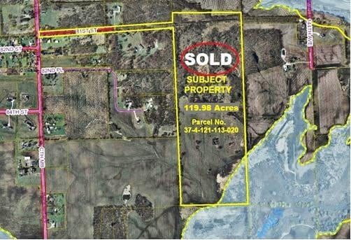
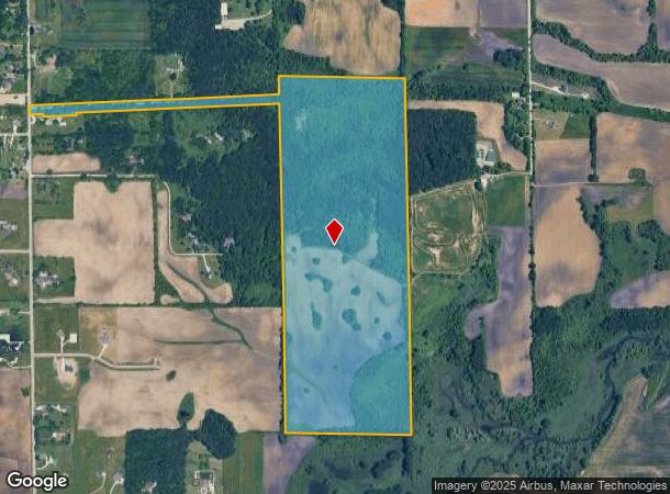
75Th St
Kenosha, WI
247-B PT NW 1/4 & SW 1/4 OF SW 1/4 OF SEC 11 & NE 1/4 & NW 1/4 OF SE 1/4 SEC 10 & NW 1/4 OF NW 1/4 SEC 14 T 1 R 21 COM AT SW
37-4-121-113-0200
Kenosha
Agriculturalland
Wisconsin
AE
200
55059C0186D
112.84 AC
2024
Kenosha East
2024
Chicago
002700
DEMOGRAPHICS near 75Th St
1 Mile
3 Mile
5 Mile
2024 Total Population
499
7,635
22,031
2029 Population
511
7,709
22,103
Pop Growth 2024-2029
+ 2.40%
+ 0.97%
+ 0.33%
Average Age
40
39
40
2024 Total Households
188
2,856
8,461
HH Growth 2024-2029
+ 2.66%
+ 0.98%
+ 0.33%
Median Household Inc
$124,218
$98,472
$94,585
Avg Household Size
2.60
2.60
2.60
2024 Avg HH Vehicles
2.00
2.00
2.00
Median Home Value
$453,749
$346,895
$306,860
Median Year Built
2005
1997
1998
Nearby Places
Map Layers
Map Styles
 Street
 Aerial
- Restaurants
- Banks
- Shops
- Fitness
- Groceries
PUBLIC TRANSPORTATION
AIRPORT
General Mitchell International
DRIVE
WALK
Distance
General Mitchell International
41 min
31.8 mi
Freight Ports
Port Milwaukee
DRIVE
WALK
Distance
Port Milwaukee
45 min
35.7 mi
SALE & LEASE HISTORY
LISTING DATE
SALE/LEASE

Sep 15, 2017
For Sale
Nearby Properties
Address
Land Use
TOTAL SIZE
Lot Size
Zoning
Address
Land Use
TOTAL SIZE
Lot Size
Zoning
1,083,094 SF
230.85 AC
Address
Land Use
TOTAL SIZE
Lot Size
Zoning
159,194 SF
136.60 AC
Address
Land Use
TOTAL SIZE
Lot Size
Zoning
51,119 SF
63.71 AC
Address
Land Use
TOTAL SIZE
Lot Size
Zoning
108,727 SF
67.52 AC
Address
Land Use
TOTAL SIZE
Lot Size
Zoning
12,876 SF
30.13 AC
Address
Land Use
TOTAL SIZE
Lot Size
Zoning
38,201 SF
16 AC
Address
Land Use
TOTAL SIZE
Lot Size
Zoning
16.01 AC
Address
Land Use
TOTAL SIZE
Lot Size
Zoning
27.77 AC
Address
Land Use
TOTAL SIZE
Lot Size
Zoning
418,036 SF
25.33 AC
Address
Land Use
TOTAL SIZE
Lot Size
Zoning
447,200 SF
23.50 AC
Address
Land Use
TOTAL SIZE
Lot Size
Zoning
396,508 SF
21.72 AC
Address
Land Use
TOTAL SIZE
Lot Size
Zoning
13.10 AC
Address
Land Use
TOTAL SIZE
Lot Size
Zoning
31,809 SF
11.36 AC
BASE
Address
Land Use
TOTAL SIZE
Lot Size
Zoning
21.62 AC
Address
Land Use
TOTAL SIZE
Lot Size
Zoning
314,505 SF
19.30 AC
Address
Land Use
TOTAL SIZE
Lot Size
Zoning
55,140 SF
21 AC
FW
Address
Land Use
TOTAL SIZE
Lot Size
Zoning
247,185 SF
18.21 AC
B2
Address
Land Use
TOTAL SIZE
Lot Size
Zoning
69,568 SF
37.52 AC
Address
Land Use
TOTAL SIZE
Lot Size
Zoning
157,656 SF
10.92 AC
Address
Land Use
TOTAL SIZE
Lot Size
Zoning
11.13 AC
Address
Land Use
TOTAL SIZE
Lot Size
Zoning
20,950 SF
11.11 AC
Address
Land Use
TOTAL SIZE
Lot Size
Zoning
30,507 SF
20.89 AC
IP
Address
Land Use
TOTAL SIZE
Lot Size
Zoning
35,645 SF
20.89 AC
IP
Address
Land Use
TOTAL SIZE
Lot Size
Zoning
4.07 AC
B2
Address
Land Use
TOTAL SIZE
Lot Size
Zoning
56,300 SF
9.03 AC
Address
Land Use
TOTAL SIZE
Lot Size
Zoning
99,846 SF
6.36 AC
B2
Address
Land Use
TOTAL SIZE
Lot Size
Zoning
61,288 SF
4.27 AC
Address
Land Use
TOTAL SIZE
Lot Size
Zoning
25,911 SF
20.89 AC
IP
Address
Land Use
TOTAL SIZE
Lot Size
Zoning
30,897 SF
9.34 AC
Address
Land Use
TOTAL SIZE
Lot Size
Zoning
12.60 AC
The World's #1 Commercial Real Estate Marketplace
Connect with us
© 2026 CoStar Group
The information above has been obtained from sources believed reliable. While we do not doubt its accuracy we have not verified it and make no guarantee, warranty or representation about it. It is your responsibility to independently confirm its accuracy and completeness. Any projections, opinions, assumptions, or estimates used are for example only and do not represent the current or future performance of the property. The value of this transaction to you depends on tax and other factors which should be evaluated by your tax, financial, and legal advisors. You and your advisors should conduct a careful, independent investigation of the property to determine to your satisfaction the suitability of the property for your needs.