Property Record
76 Mamalahoa Hwy, Holualoa, HI 96725
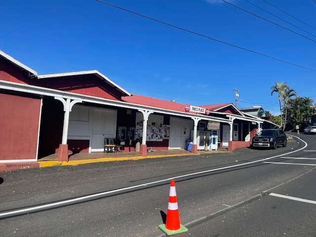
This Property Is For Sale
NEARBY LISTINGS FOR SALE OR LEASE
Property Detail
76 Mamalahoa Hwy
3-7-6-008-019-0002
Holualoa 1 & 2 Partition Lots-Makai Sec.
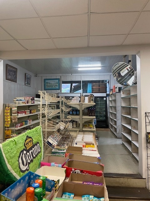
Commercialnec
UNIT B OLD HOLUALOA POST OFFICE CONDO MAP 4249 TOG/EXCL ESMT TO USE APPURTENANT LAND AREA 1782 SF UND 50% INT IN COMMON ELEMENTS
X
Hawaii
1551660952F
Hawaii
2024
0.04 AC
2025
Kona/West Big Island
021502
Hawaii
3,542 SF
Hilo, HI
DEMOGRAPHICS near 76 Mamalahoa Hwy
1 Mile
3 Mile
5 Mile
2024 Total Population
1,918
22,301
35,020
2029 Population
1,957
24,361
38,321
Pop Growth 2024-2029
+ 2.03%
+ 9.24%
+ 9.43%
Average Age
46
45
44
2024 Total Households
675
8,728
13,089
HH Growth 2024-2029
+ 1.78%
+ 9.54%
+ 9.86%
Median Household Inc
$93,160
$81,296
$80,490
Avg Household Size
2.70
2.40
2.50
2024 Avg HH Vehicles
2.00
2.00
2.00
Median Home Value
$848,122
$699,149
$708,962
Median Year Built
1985
1987
1987
Nearby Places
- Restaurants
- Banks
- Shops
- Fitness
- Groceries
PUBLIC TRANSPORTATION
AIRPORT
Ellison Onizuka Kona International at Keahole
DRIVE
WALK
Distance
Ellison Onizuka Kona International at Keahole
28 min
13.1 mi
Nearby Properties
Address
Land Use
TOTAL SIZE
Lot Size
Zoning
Address
Land Use
TOTAL SIZE
Lot Size
Zoning
101,191 SF
40.34 AC
RM-4
Address
Land Use
TOTAL SIZE
Lot Size
Zoning
167,450 SF
1.81 AC
V-.75
Address
Land Use
TOTAL SIZE
Lot Size
Zoning
53,072 SF
5.21 AC
RM-1
Address
Land Use
TOTAL SIZE
Lot Size
Zoning
18,432 SF
1.44 AC
V-.75
Address
Land Use
TOTAL SIZE
Lot Size
Zoning
10.04 AC
V-1.25
Address
Land Use
TOTAL SIZE
Lot Size
Zoning
6,042 SF
5.50 AC
RM-4
Address
Land Use
TOTAL SIZE
Lot Size
Zoning
89,870 SF
3.98 AC
A-5a
Address
Land Use
TOTAL SIZE
Lot Size
Zoning
45,547 SF
3.01 AC
CV-10
Address
Land Use
TOTAL SIZE
Lot Size
Zoning
29,128 SF
2.99 AC
V-.75
Address
Land Use
TOTAL SIZE
Lot Size
Zoning
5.33 AC
RS-15
Address
Land Use
TOTAL SIZE
Lot Size
Zoning
6.87 AC
RM-2
Address
Land Use
TOTAL SIZE
Lot Size
Zoning
288.28 AC
A-5a
Address
Land Use
TOTAL SIZE
Lot Size
Zoning
28,248 SF
1.49 AC
CV-7.5
Address
Land Use
TOTAL SIZE
Lot Size
Zoning
18.99 AC
CV-10
Address
Land Use
TOTAL SIZE
Lot Size
Zoning
47,685 SF
3.90 AC
RM-3
Address
Land Use
TOTAL SIZE
Lot Size
Zoning
6,825 SF
5.08 AC
A-5a
Address
Land Use
TOTAL SIZE
Lot Size
Zoning
12,342 SF
5.08 AC
A-5a
Address
Land Use
TOTAL SIZE
Lot Size
Zoning
25,060 SF
3.80 AC
CV-10
Address
Land Use
TOTAL SIZE
Lot Size
Zoning
7,308 SF
5 AC
A-5a
Address
Land Use
TOTAL SIZE
Lot Size
Zoning
3.08 AC
RS-15
Address
Land Use
TOTAL SIZE
Lot Size
Zoning
6,042 SF
4.95 AC
RM-4
Address
Land Use
TOTAL SIZE
Lot Size
Zoning
2,632 SF
2.49 AC
V-2.25
Address
Land Use
TOTAL SIZE
Lot Size
Zoning
24,676 SF
2.54 AC
CV-10
Address
Land Use
TOTAL SIZE
Lot Size
Zoning
4.20 AC
RS-15
Address
Land Use
TOTAL SIZE
Lot Size
Zoning
10,528 SF
9.30 AC
A-5a
Address
Land Use
TOTAL SIZE
Lot Size
Zoning
7,717 SF
6 AC
A-5a
Address
Land Use
TOTAL SIZE
Lot Size
Zoning
23,230 SF
1.15 AC
V-.75
The World's #1 Commercial Real Estate Marketplace
Connect with us
© 2025 CoStar Group
The information above has been obtained from sources believed reliable. While we do not doubt its accuracy we have not verified it and make no guarantee, warranty or representation about it. It is your responsibility to independently confirm its accuracy and completeness. Any projections, opinions, assumptions, or estimates used are for example only and do not represent the current or future performance of the property. The value of this transaction to you depends on tax and other factors which should be evaluated by your tax, financial, and legal advisors. You and your advisors should conduct a careful, independent investigation of the property to determine to your satisfaction the suitability of the property for your needs.