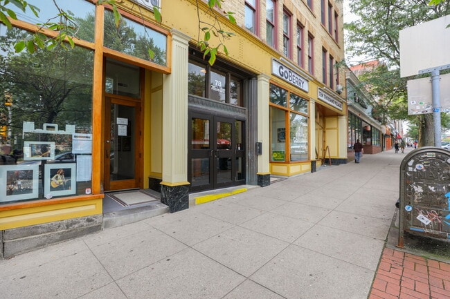
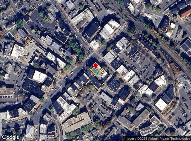
Property Record
76 Main St, Northampton, MA 01060
NEARBY LISTINGS FOR SALE OR LEASE
Property Detail
76 Main St
Amherst Town-Northampton, MA
42 Pleasant
NHAM-000032C-000017-000001
Hampshire
Officebuilding
Massachusetts
2025
1
2025
0.10 AC
821903
Hampshire County
24,658 SF
Hartford
DEMOGRAPHICS near 76 Main St
1 mile
3 mile
5 mile
2024 Total Population
11,010
24,259
45,550
2029 Population
9,016
19,440
36,219
Pop Growth 2024-2029
(18.11%)
(19.86%)
(20.49%)
Average Age
38
42
44
2024 Total Households
4,583
10,603
20,213
HH Growth 2024-2029
(21.78%)
(21.93%)
(21.86%)
Median Household Inc
$69,465
$73,009
$72,918
Avg Household Size
1.90
2.00
2.10
2024 Avg HH Vehicles
1.00
2.00
2.00
Median Home Value
$414,595
$391,433
$369,001
Median Year Built
1947
1950
1956
Nearby Places
Map Layers
Map Styles
 Street
 Aerial
Transit
 Traffic
 Biking
Places
Listings with unknown addresses are not visible on the map
- Restaurants
- Banks
- Shops
- Fitness
- Groceries
PUBLIC TRANSPORTATION
COMMUTER RAIL
Drive
Walk
Distance
2 min
5 min
0.3 mi
AIRPORT
Bradley International
Drive
Walk
Distance
Bradley International
50 min
29.7 mi
SALE & LEASE HISTORY
LISTING DATE
SALE/LEASE

Sep 25, 2016
For Lease
Jun 21, 2023
For Lease
Jul 29, 2021
For Lease
Nearby Properties
Address
Land Use
TOTAL SIZE
Lot Size
Zoning
Address
Land Use
TOTAL SIZE
Lot Size
Zoning
18.04 AC
URB
Address
Land Use
TOTAL SIZE
Lot Size
Zoning
5.65 AC
URC
Address
Land Use
TOTAL SIZE
Lot Size
Zoning
5.84 AC
URC
Address
Land Use
TOTAL SIZE
Lot Size
Zoning
17.40 AC
SC
Address
Land Use
TOTAL SIZE
Lot Size
Zoning
150,256 SF
13.58 AC
Address
Land Use
TOTAL SIZE
Lot Size
Zoning
61,650 SF
12.37 AC
B
Address
Land Use
TOTAL SIZE
Lot Size
Zoning
26.50 AC
URB
Address
Land Use
TOTAL SIZE
Lot Size
Zoning
29.13 AC
RR
Address
Land Use
TOTAL SIZE
Lot Size
Zoning
12.23 AC
HB
Address
Land Use
TOTAL SIZE
Lot Size
Zoning
30.42 AC
URB
Address
Land Use
TOTAL SIZE
Lot Size
Zoning
7.58 AC
HB
Address
Land Use
TOTAL SIZE
Lot Size
Zoning
10.37 AC
HB
Address
Land Use
TOTAL SIZE
Lot Size
Zoning
243,012 SF
24.96 AC
URB
Address
Land Use
TOTAL SIZE
Lot Size
Zoning
0.12 AC
URC
Address
Land Use
TOTAL SIZE
Lot Size
Zoning
55,964 SF
0.36 AC
URC
Address
Land Use
TOTAL SIZE
Lot Size
Zoning
2.69 AC
URC
Address
Land Use
TOTAL SIZE
Lot Size
Zoning
21.77 AC
GI
Address
Land Use
TOTAL SIZE
Lot Size
Zoning
1.77 AC
URC
Address
Land Use
TOTAL SIZE
Lot Size
Zoning
88,144 SF
0.35 AC
CB
Address
Land Use
TOTAL SIZE
Lot Size
Zoning
1.47 AC
URC
Address
Land Use
TOTAL SIZE
Lot Size
Zoning
85,816 SF
6.80 AC
URB
Address
Land Use
TOTAL SIZE
Lot Size
Zoning
98,482 SF
1.03 AC
CB
Address
Land Use
TOTAL SIZE
Lot Size
Zoning
2.51 AC
URC
Address
Land Use
TOTAL SIZE
Lot Size
Zoning
4.19 AC
HB
Address
Land Use
TOTAL SIZE
Lot Size
Zoning
13,608 SF
11 AC
RR
Address
Land Use
TOTAL SIZE
Lot Size
Zoning
80,161 SF
2.08 AC
URC
Address
Land Use
TOTAL SIZE
Lot Size
Zoning
45,480 SF
3.48 AC
GB
Address
Land Use
TOTAL SIZE
Lot Size
Zoning
2.51 AC
URC
Address
Land Use
TOTAL SIZE
Lot Size
Zoning
42,070 SF
4.38 AC
URA
Address
Land Use
TOTAL SIZE
Lot Size
Zoning
162,055 SF
2.92 AC
CB
The World's #1 Commercial Real Estate Marketplace
Connect with us
© 2026 CoStar Group
The information above has been obtained from sources believed reliable. While we do not doubt its accuracy we have not verified it and make no guarantee, warranty or representation about it. It is your responsibility to independently confirm its accuracy and completeness. Any projections, opinions, assumptions, or estimates used are for example only and do not represent the current or future performance of the property. The value of this transaction to you depends on tax and other factors which should be evaluated by your tax, financial, and legal advisors. You and your advisors should conduct a careful, independent investigation of the property to determine to your satisfaction the suitability of the property for your needs.