Property Record
76 Address Unassigned, , MN
Property Detail
76 Address Unassigned
Minneapolis-St. Paul-Bloomington, MN-WI
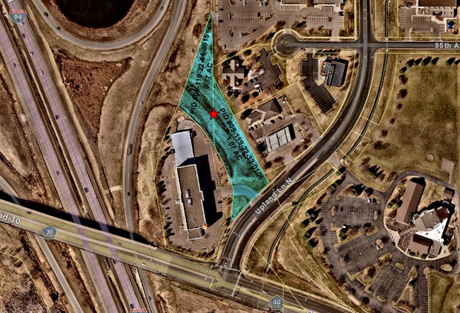
UNPLATTED 09 118 22 THAT PART OF THE SOUTHWEST QUARTER OF THE SOUTHWEST QUARTER OF SECTION 9, TOWNSHIP 119 NORTH, RANGE 22 WEST, HENNEPIN COUNTY, MINNESOTA, LYING T IRREGULAR
08-119-22-44-0015
HENNEPIN
Commercialacreage
Minnesota
B and X Area of moderate flood hazard, usually the area between the limits of the 100-year and 500-year floods.
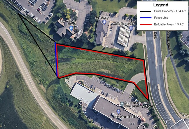
0.77 AC
0
Northwest
2024
Minneapolis/St Paul
026720
NEARBY LISTINGS FOR SALE OR LEASE
DEMOGRAPHICS near 76 Address Unassigned
1 mile
3 mile
5 mile
2024 Total Population
5,979
43,321
97,715
2029 Population
6,166
43,987
98,957
Pop Growth 2024-2029
+ 3.13%
+ 1.54%
+ 1.27%
Average Age
42
41
40
2024 Total Households
2,346
16,214
36,400
HH Growth 2024-2029
+ 3.03%
+ 1.38%
+ 1.13%
Median Household Inc
$113,376
$135,043
$132,124
Avg Household Size
2.40
2.60
2.60
2024 Avg HH Vehicles
2.00
2.00
2.00
Median Home Value
$414,738
$434,008
$439,153
Median Year Built
1996
1994
1994
Nearby Places
Map Layers
Map Styles
 Street
 Aerial
Transit
 Traffic
 Biking
Places
Listings with unknown addresses are not visible on the map
- Restaurants
- Banks
- Shops
- Fitness
- Groceries
PUBLIC TRANSPORTATION
AIRPORT
Minneapolis-St Paul International/Wold-Chamberlain
Drive
Walk
Distance
Minneapolis-St Paul International/Wold-Chamberlain
44 min
31.9 mi
Freight Ports
Port Milwaukee
Drive
Walk
Distance
Port Milwaukee
396 min
357.1 mi
SALE & LEASE HISTORY
LISTING DATE
SALE/LEASE

Feb 03, 2021
For Lease
Feb 03, 2021
For Sale
Nearby Properties
Address
Land Use
TOTAL SIZE
Lot Size
Zoning
Address
Land Use
TOTAL SIZE
Lot Size
Zoning
4.33 AC
Address
Land Use
TOTAL SIZE
Lot Size
Zoning
68.12 AC
Address
Land Use
TOTAL SIZE
Lot Size
Zoning
42.21 AC
Address
Land Use
TOTAL SIZE
Lot Size
Zoning
297,060 SF
19.17 AC
Address
Land Use
TOTAL SIZE
Lot Size
Zoning
25.06 AC
Address
Land Use
TOTAL SIZE
Lot Size
Zoning
7.53 AC
Address
Land Use
TOTAL SIZE
Lot Size
Zoning
8.11 AC
Address
Land Use
TOTAL SIZE
Lot Size
Zoning
Address
Land Use
TOTAL SIZE
Lot Size
Zoning
Address
Land Use
TOTAL SIZE
Lot Size
Zoning
Address
Land Use
TOTAL SIZE
Lot Size
Zoning
58,119 SF
18.55 AC
Address
Land Use
TOTAL SIZE
Lot Size
Zoning
228,208 SF
24.92 AC
Address
Land Use
TOTAL SIZE
Lot Size
Zoning
90,700 SF
17.07 AC
Address
Land Use
TOTAL SIZE
Lot Size
Zoning
17.75 AC
Address
Land Use
TOTAL SIZE
Lot Size
Zoning
10.44 AC
Address
Land Use
TOTAL SIZE
Lot Size
Zoning
132,200 SF
28.23 AC
Address
Land Use
TOTAL SIZE
Lot Size
Zoning
17.09 AC
Address
Land Use
TOTAL SIZE
Lot Size
Zoning
Address
Land Use
TOTAL SIZE
Lot Size
Zoning
Address
Land Use
TOTAL SIZE
Lot Size
Zoning
20.09 AC
Address
Land Use
TOTAL SIZE
Lot Size
Zoning
Address
Land Use
TOTAL SIZE
Lot Size
Zoning
218,144 SF
3.71 AC
Address
Land Use
TOTAL SIZE
Lot Size
Zoning
32,169 SF
9.58 AC
Address
Land Use
TOTAL SIZE
Lot Size
Zoning
11.61 AC
Address
Land Use
TOTAL SIZE
Lot Size
Zoning
10.26 AC
Address
Land Use
TOTAL SIZE
Lot Size
Zoning
219,980 SF
18.09 AC
Address
Land Use
TOTAL SIZE
Lot Size
Zoning
168,961 SF
15.61 AC
Address
Land Use
TOTAL SIZE
Lot Size
Zoning
175,096 SF
18.91 AC
Address
Land Use
TOTAL SIZE
Lot Size
Zoning
178,023 SF
14.24 AC
Address
Land Use
TOTAL SIZE
Lot Size
Zoning
144,927 SF
28.23 AC
The World's #1 Commercial Real Estate Marketplace
Connect with us
© 2026 CoStar Group
The information above has been obtained from sources believed reliable. While we do not doubt its accuracy we have not verified it and make no guarantee, warranty or representation about it. It is your responsibility to independently confirm its accuracy and completeness. Any projections, opinions, assumptions, or estimates used are for example only and do not represent the current or future performance of the property. The value of this transaction to you depends on tax and other factors which should be evaluated by your tax, financial, and legal advisors. You and your advisors should conduct a careful, independent investigation of the property to determine to your satisfaction the suitability of the property for your needs.