Property Record
76 E Cedar Fork Rd, Richmond, VA 23223


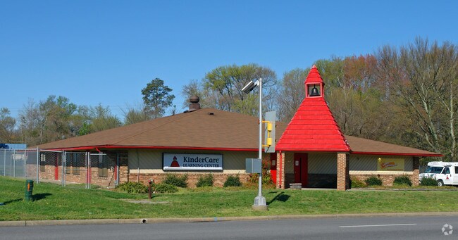
Property Detail
76 E Cedar Fork Rd
813-725-3853
0147140000A 0002; PARRISH SUBDIVISION SC 1 LT 2 1 ACRE 8 B2 95
Daycare
HENRICO
B-2
Virginia
B and X Area of moderate flood hazard, usually the area between the limits of the 100-year and 500-year floods.
1-2
2026
1 AC
2026
Laburnum/Rte 360
201104
Richmond VA
5,043 SF
Richmond, VA
NEARBY LISTINGS FOR SALE OR LEASE
DEMOGRAPHICS near 76 E Cedar Fork Rd
1 mile
3 mile
5 mile
2025 Total Population
10,488
60,922
164,539
2030 Population
10,604
62,168
169,587
Pop Growth 2025-2030
+ 1.11%
+ 2.05%
+ 3.07%
Average Age
40
40
38
2025 Total Households
4,265
25,036
71,664
HH Growth 2025-2030
+ 1.24%
+ 2.13%
+ 3.30%
Median Household Inc
$58,041
$56,800
$62,325
Avg Household Size
2.40
2.40
2.20
2025 Avg HH Vehicles
2.00
2.00
2.00
Median Home Value
$253,535
$249,947
$275,895
Median Year Built
1984
1976
1973
Nearby Places
Map Layers
Map Styles
 Street
 Aerial
Layers
 Traffic
 Biking
Places
Listings with unknown addresses are not visible on the map
- Restaurants
- Banks
- Shops
- Fitness
- Groceries
PUBLIC TRANSPORTATION
COMMUTER RAIL
Drive
Walk
Distance
8 min
4.7 mi
AIRPORT
Richmond International
Drive
Walk
Distance
Richmond International
12 min
5.8 mi
Freight Ports
Virginia Port Authority - Richmond
Drive
Walk
Distance
Virginia Port Authority - Richmond
20 min
11.2 mi
Nearby Properties
Address
Land Use
TOTAL SIZE
Lot Size
Zoning
Address
Land Use
TOTAL SIZE
Lot Size
Zoning
272,410 SF
56.39 AC
MIXED
Address
Land Use
TOTAL SIZE
Lot Size
Zoning
281,456 SF
84.22 AC
R-5
Address
Land Use
TOTAL SIZE
Lot Size
Zoning
331,455 SF
12.75 AC
UMUC
Address
Land Use
TOTAL SIZE
Lot Size
Zoning
84,124 SF
61.99 AC
B-3C
Address
Land Use
TOTAL SIZE
Lot Size
Zoning
57,128 SF
89.49 AC
R-5
Address
Land Use
TOTAL SIZE
Lot Size
Zoning
273,822 SF
22.74 AC
R-5
Address
Land Use
TOTAL SIZE
Lot Size
Zoning
141,540 SF
31.21 AC
M-1
Address
Land Use
TOTAL SIZE
Lot Size
Zoning
522,399 SF
58.07 AC
M-1
Address
Land Use
TOTAL SIZE
Lot Size
Zoning
186,390 SF
13.50 AC
R-5
Address
Land Use
TOTAL SIZE
Lot Size
Zoning
173,637 SF
15.48 AC
R-5
Address
Land Use
TOTAL SIZE
Lot Size
Zoning
69,297 SF
49.66 AC
A-1
Address
Land Use
TOTAL SIZE
Lot Size
Zoning
444,069 SF
23.82 AC
M-1
Address
Land Use
TOTAL SIZE
Lot Size
Zoning
322,000 SF
15.94 AC
M-1
Address
Land Use
TOTAL SIZE
Lot Size
Zoning
235,336 SF
18.67 AC
MIXED
Address
Land Use
TOTAL SIZE
Lot Size
Zoning
152,064 SF
34.67 AC
R-53 MULTI
Address
Land Use
TOTAL SIZE
Lot Size
Zoning
182,280 SF
33.19 AC
MULTIPLE Z
Address
Land Use
TOTAL SIZE
Lot Size
Zoning
115,152 SF
2.37 AC
R-6 SINGLE
Address
Land Use
TOTAL SIZE
Lot Size
Zoning
44,891 SF
8.88 AC
R-THC
Address
Land Use
TOTAL SIZE
Lot Size
Zoning
53,530 SF
4.50 AC
M-1C
Address
Land Use
TOTAL SIZE
Lot Size
Zoning
15,680 SF
39.75 AC
R-3
Address
Land Use
TOTAL SIZE
Lot Size
Zoning
91,642 SF
45.95 AC
A-1
Address
Land Use
TOTAL SIZE
Lot Size
Zoning
125,514 SF
13 AC
M-1C
Address
Land Use
TOTAL SIZE
Lot Size
Zoning
99,967 SF
7.89 AC
R-6 SINGLE
Address
Land Use
TOTAL SIZE
Lot Size
Zoning
179,359 SF
11.85 AC
M-1
Address
Land Use
TOTAL SIZE
Lot Size
Zoning
190,138 SF
16.99 AC
MIXED
Address
Land Use
TOTAL SIZE
Lot Size
Zoning
111,729 SF
6.58 AC
MIXED
Address
Land Use
TOTAL SIZE
Lot Size
Zoning
8,440 SF
8.27 AC
R-6
Address
Land Use
TOTAL SIZE
Lot Size
Zoning
143,332 SF
6.12 AC
M-1C
Address
Land Use
TOTAL SIZE
Lot Size
Zoning
77,332 SF
3.63 AC
R-02 RESID
Address
Land Use
TOTAL SIZE
Lot Size
Zoning
106,184 SF
20.01 AC
R-48 MULTI
The World's #1 Commercial Real Estate Marketplace
Connect with us
© 2026 CoStar Group
The information above has been obtained from sources believed reliable. While we do not doubt its accuracy we have not verified it and make no guarantee, warranty or representation about it. It is your responsibility to independently confirm its accuracy and completeness. Any projections, opinions, assumptions, or estimates used are for example only and do not represent the current or future performance of the property. The value of this transaction to you depends on tax and other factors which should be evaluated by your tax, financial, and legal advisors. You and your advisors should conduct a careful, independent investigation of the property to determine to your satisfaction the suitability of the property for your needs.