Property Record
76 State Highway 248, Reeds Spring, MO 65737

NEARBY LISTINGS FOR SALE OR LEASE
Property Detail
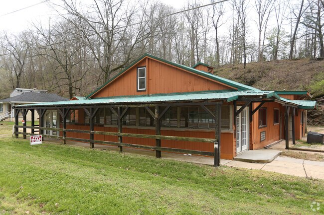
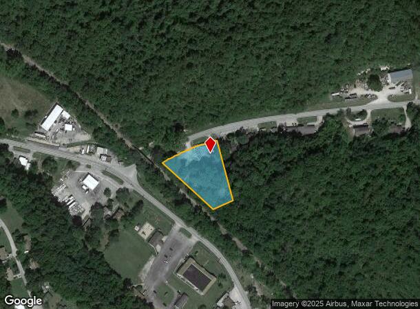
76 State Highway 248
08-7.0-26-001-007-004.002
Plummers
Warehouse
PLUMMERS LOT 1
A
Stone
29209C0119D
Missouri
2024
1
2025
1.88 AC
090606
Branson
1,248 SF
Other Market Areas
DEMOGRAPHICS near 76 State Highway 248
1 Mile
3 Mile
5 Mile
2024 Total Population
593
2,636
4,390
2029 Population
632
2,816
4,683
Pop Growth 2024-2029
+ 6.58%
+ 6.83%
+ 6.67%
Average Age
41
42
43
2024 Total Households
229
1,031
1,711
HH Growth 2024-2029
+ 5.68%
+ 6.01%
+ 5.90%
Median Household Inc
$33,888
$41,562
$46,838
Avg Household Size
2.50
2.50
2.40
2024 Avg HH Vehicles
2.00
2.00
2.00
Median Home Value
$127,272
$159,799
$181,098
Median Year Built
1986
1989
1991
Nearby Places
Map Layers
Map Styles
 Street
 Aerial
- Restaurants
- Banks
- Shops
- Fitness
- Groceries
SALE & LEASE HISTORY
LISTING DATE
SALE/LEASE

May 07, 2018
For Sale
Nearby Properties
Address
Land Use
TOTAL SIZE
Lot Size
Zoning
Address
Land Use
TOTAL SIZE
Lot Size
Zoning
108,452 SF
47.84 AC
A-1
Address
Land Use
TOTAL SIZE
Lot Size
Zoning
74,763 SF
28.27 AC
NA
Address
Land Use
TOTAL SIZE
Lot Size
Zoning
15,000 SF
2.32 AC
NA
Address
Land Use
TOTAL SIZE
Lot Size
Zoning
93,998 SF
39 AC
NA
Address
Land Use
TOTAL SIZE
Lot Size
Zoning
8,100 SF
1.13 AC
Address
Land Use
TOTAL SIZE
Lot Size
Zoning
9,064 SF
1.40 AC
RR-1
Address
Land Use
TOTAL SIZE
Lot Size
Zoning
8,964 SF
1.76 AC
NA
Address
Land Use
TOTAL SIZE
Lot Size
Zoning
15,039 SF
2 AC
NA
Address
Land Use
TOTAL SIZE
Lot Size
Zoning
12,338 SF
7.81 AC
C-2
Address
Land Use
TOTAL SIZE
Lot Size
Zoning
6,634 SF
24.06 AC
NA
Address
Land Use
TOTAL SIZE
Lot Size
Zoning
43,104 SF
5.86 AC
C-2
Address
Land Use
TOTAL SIZE
Lot Size
Zoning
22,500 SF
12.15 AC
NA
Address
Land Use
TOTAL SIZE
Lot Size
Zoning
3,321 SF
2.60 AC
R-1
Address
Land Use
TOTAL SIZE
Lot Size
Zoning
11,633 SF
13.80 AC
C-2
Address
Land Use
TOTAL SIZE
Lot Size
Zoning
3,192 SF
3.50 AC
C-2
Address
Land Use
TOTAL SIZE
Lot Size
Zoning
1,600 SF
6.60 AC
A-1
Address
Land Use
TOTAL SIZE
Lot Size
Zoning
16,320 SF
3.50 AC
NA
Address
Land Use
TOTAL SIZE
Lot Size
Zoning
18,200 SF
2.04 AC
NA
Address
Land Use
TOTAL SIZE
Lot Size
Zoning
29,468 SF
15.36 AC
NA
Address
Land Use
TOTAL SIZE
Lot Size
Zoning
3,600 SF
0.26 AC
NA
Address
Land Use
TOTAL SIZE
Lot Size
Zoning
19,880 SF
3.25 AC
C-2
Address
Land Use
TOTAL SIZE
Lot Size
Zoning
18,180 SF
1.36 AC
NA
Address
Land Use
TOTAL SIZE
Lot Size
Zoning
11,520 SF
1.60 AC
NA
Address
Land Use
TOTAL SIZE
Lot Size
Zoning
2,394 SF
0.69 AC
NA
Address
Land Use
TOTAL SIZE
Lot Size
Zoning
1,812 SF
1.37 AC
RR-1
Address
Land Use
TOTAL SIZE
Lot Size
Zoning
6,827 SF
1.50 AC
C-2
Address
Land Use
TOTAL SIZE
Lot Size
Zoning
3,989 SF
1.10 AC
NA
Address
Land Use
TOTAL SIZE
Lot Size
Zoning
15,340 SF
2.90 AC
C-2
Address
Land Use
TOTAL SIZE
Lot Size
Zoning
9,968 SF
1.50 AC
C-2
The World's #1 Commercial Real Estate Marketplace
Connect with us
© 2026 CoStar Group
The information above has been obtained from sources believed reliable. While we do not doubt its accuracy we have not verified it and make no guarantee, warranty or representation about it. It is your responsibility to independently confirm its accuracy and completeness. Any projections, opinions, assumptions, or estimates used are for example only and do not represent the current or future performance of the property. The value of this transaction to you depends on tax and other factors which should be evaluated by your tax, financial, and legal advisors. You and your advisors should conduct a careful, independent investigation of the property to determine to your satisfaction the suitability of the property for your needs.