No Photo
Property Record
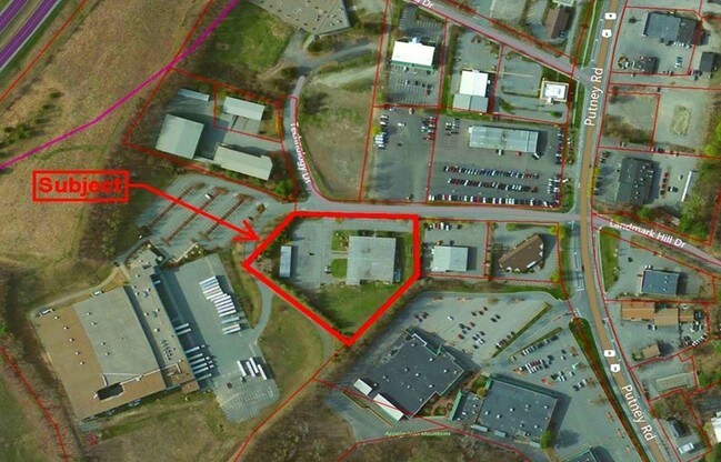
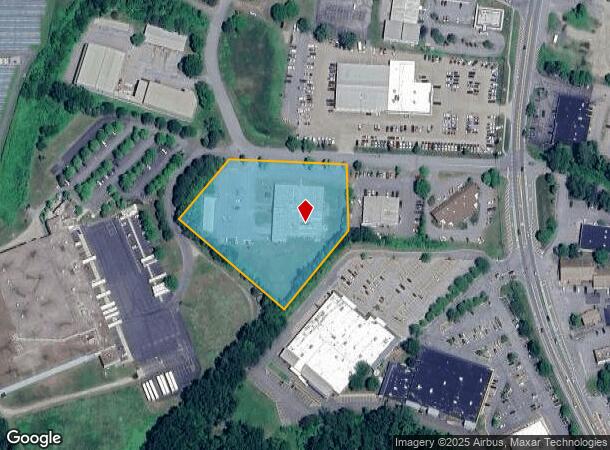
76 Technology Dr, Brattleboro, VT 05301
NEARBY LISTINGS FOR SALE OR LEASE
-
-
View all Brattleboro listings for lease on LoopNet.com
Property Detail
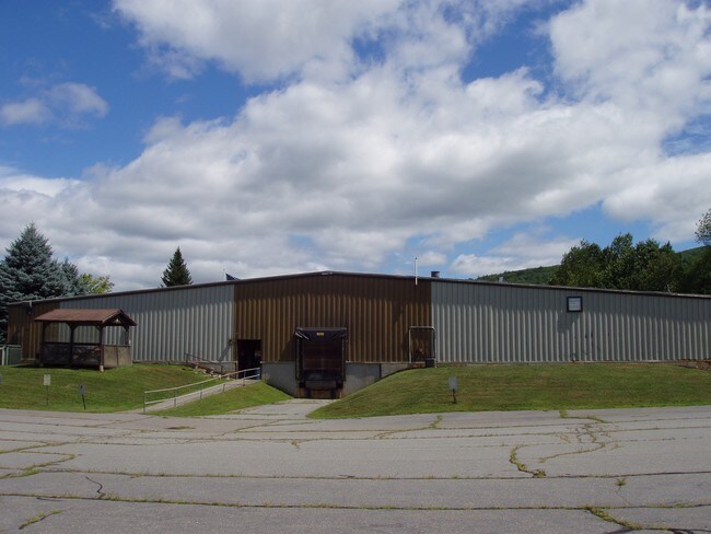
76 Technology Dr
Industrialgeneral
INDUSTRIAL BUILDING/LAND
X
Windham
50025C0389E
Vermont
2024
3.09 AC
2024
Other Market Areas
968600
081-025-15411
20,400 SF
DEMOGRAPHICS near 76 Technology Dr
1 Mile
3 Mile
5 Mile
2024 Total Population
667
12,007
16,693
2029 Population
666
12,037
16,803
Pop Growth 2024-2029
(0.15%)
+ 0.25%
+ 0.66%
Average Age
46
45
45
2024 Total Households
294
5,829
7,822
HH Growth 2024-2029
0.00%
+ 0.36%
+ 0.61%
Median Household Inc
$57,058
$46,545
$54,397
Avg Household Size
2.00
1.90
2.00
2024 Avg HH Vehicles
2.00
1.00
2.00
Median Home Value
$279,268
$228,324
$235,167
Median Year Built
1963
1969
1972
Nearby Places
Map Layers
Map Styles
 Street
 Aerial
- Restaurants
- Banks
- Shops
- Fitness
- Groceries
PUBLIC TRANSPORTATION
COMMUTER RAIL
Brattleboro Amtrak Station (Vermonter - Amtrak)
DRIVE
WALK
Distance
Brattleboro Amtrak Station (Vermonter - Amtrak)
6 min
2.1 mi
Freight Ports
Albany, NY Port
DRIVE
WALK
Distance
Albany, NY Port
136 min
84.2 mi
SALE & LEASE HISTORY
LISTING DATE
SALE/LEASE

Sep 24, 2016
For Sale
Dec 06, 2019
For Lease
Nearby Properties
Address
Land Use
TOTAL SIZE
Lot Size
Zoning
Address
Land Use
TOTAL SIZE
Lot Size
Zoning
211,712 SF
45.69 AC
IP / I
Address
Land Use
TOTAL SIZE
Lot Size
Zoning
Address
Land Use
TOTAL SIZE
Lot Size
Zoning
53,655 SF
11.95 AC
IP
Address
Land Use
TOTAL SIZE
Lot Size
Zoning
63.75 AC
I / IN
Address
Land Use
TOTAL SIZE
Lot Size
Zoning
Address
Land Use
TOTAL SIZE
Lot Size
Zoning
Address
Land Use
TOTAL SIZE
Lot Size
Zoning
367 AC
R / RU
Address
Land Use
TOTAL SIZE
Lot Size
Zoning
25.40 AC
Address
Land Use
TOTAL SIZE
Lot Size
Zoning
25,246 SF
1.11 AC
Address
Land Use
TOTAL SIZE
Lot Size
Zoning
15.56 AC
C / CO
Address
Land Use
TOTAL SIZE
Lot Size
Zoning
14,325 SF
IP / I
Address
Land Use
TOTAL SIZE
Lot Size
Zoning
21,865 SF
0.96 AC
Address
Land Use
TOTAL SIZE
Lot Size
Zoning
11.64 AC
CI / I
Address
Land Use
TOTAL SIZE
Lot Size
Zoning
135,935 SF
26.51 AC
N5 / N
Address
Land Use
TOTAL SIZE
Lot Size
Zoning
9.94 AC
C / CO
Address
Land Use
TOTAL SIZE
Lot Size
Zoning
11.44 AC
C / CO
Address
Land Use
TOTAL SIZE
Lot Size
Zoning
Address
Land Use
TOTAL SIZE
Lot Size
Zoning
11,388 SF
0.79 AC
UC
Address
Land Use
TOTAL SIZE
Lot Size
Zoning
5 AC
C / CO
Address
Land Use
TOTAL SIZE
Lot Size
Zoning
163,367 SF
39.52 AC
I / IN
Address
Land Use
TOTAL SIZE
Lot Size
Zoning
12,376 SF
1.51 AC
UC
Address
Land Use
TOTAL SIZE
Lot Size
Zoning
43.10 AC
RR / R
Address
Land Use
TOTAL SIZE
Lot Size
Zoning
33,579 SF
4 AC
UC
Address
Land Use
TOTAL SIZE
Lot Size
Zoning
12.89 AC
NR
Address
Land Use
TOTAL SIZE
Lot Size
Zoning
1,276 SF
32.94 AC
RR
Address
Land Use
TOTAL SIZE
Lot Size
Zoning
0.87 AC
UC
Address
Land Use
TOTAL SIZE
Lot Size
Zoning
Address
Land Use
TOTAL SIZE
Lot Size
Zoning
15,471 SF
4.75 AC
C / CO
Address
Land Use
TOTAL SIZE
Lot Size
Zoning
11,436 SF
1.92 AC
C
Address
Land Use
TOTAL SIZE
Lot Size
Zoning
3.93 AC
C
The World's #1 Commercial Real Estate Marketplace
Connect with us
© 2025 CoStar Group
The information above has been obtained from sources believed reliable. While we do not doubt its accuracy we have not verified it and make no guarantee, warranty or representation about it. It is your responsibility to independently confirm its accuracy and completeness. Any projections, opinions, assumptions, or estimates used are for example only and do not represent the current or future performance of the property. The value of this transaction to you depends on tax and other factors which should be evaluated by your tax, financial, and legal advisors. You and your advisors should conduct a careful, independent investigation of the property to determine to your satisfaction the suitability of the property for your needs.