Property Record
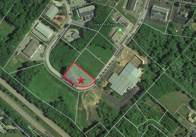
76 Upton Rd, Colchester, CT 06415
Property Detail
76 Upton Rd
COLC-000009-000000-000008-000015
NEW LONDON
Industrialgeneral
Connecticut
AC
8-13
B and X Area of moderate flood hazard, usually the area between the limits of the 100-year and 500-year floods.
1.30 AC
2025
NW New London/Colchester
2025
Hartford
714101
Norwich-New London-Willimantic, CT
20,115 SF
NEARBY LISTINGS FOR SALE OR LEASE
DEMOGRAPHICS near 76 Upton Rd
1 mile
3 mile
5 mile
2025 Total Population
2,160
11,011
20,869
2030 Population
2,172
11,145
21,229
Pop Growth 2025-2030
+ 0.56%
+ 1.22%
+ 1.73%
Average Age
44
43
43
2025 Total Households
865
4,405
8,220
HH Growth 2025-2030
+ 0.46%
+ 1.14%
+ 1.72%
Median Household Inc
$96,819
$109,354
$117,034
Avg Household Size
2.30
2.40
2.50
2025 Avg HH Vehicles
2.00
2.00
2.00
Median Home Value
$323,091
$361,073
$369,054
Median Year Built
1980
1982
1981
Nearby Places
Map Layers
Map Styles
 Street
 Aerial
Transit
 Traffic
 Biking
Places
Listings with unknown addresses are not visible on the map
- Restaurants
- Banks
- Shops
- Fitness
- Groceries
SALE & LEASE HISTORY
LISTING DATE
SALE/LEASE

Jun 07, 2019
For Sale
Nearby Properties
Address
Land Use
TOTAL SIZE
Lot Size
Zoning
Address
Land Use
TOTAL SIZE
Lot Size
Zoning
24.47 AC
SU
Address
Land Use
TOTAL SIZE
Lot Size
Zoning
40 AC
RU
Address
Land Use
TOTAL SIZE
Lot Size
Zoning
67,922 SF
14.60 AC
FD
Address
Land Use
TOTAL SIZE
Lot Size
Zoning
3,220 SF
49.91 AC
SU
Address
Land Use
TOTAL SIZE
Lot Size
Zoning
12.30 AC
TC
Address
Land Use
TOTAL SIZE
Lot Size
Zoning
1,685 SF
12.99 AC
SU
Address
Land Use
TOTAL SIZE
Lot Size
Zoning
26.44 AC
RU
Address
Land Use
TOTAL SIZE
Lot Size
Zoning
26,160 SF
8.64 AC
TC
Address
Land Use
TOTAL SIZE
Lot Size
Zoning
18,970 SF
20.41 AC
FD
Address
Land Use
TOTAL SIZE
Lot Size
Zoning
52,975 SF
16.28 AC
TC
Address
Land Use
TOTAL SIZE
Lot Size
Zoning
6.68 AC
TC
Address
Land Use
TOTAL SIZE
Lot Size
Zoning
207,049 SF
14.09 AC
TC
Address
Land Use
TOTAL SIZE
Lot Size
Zoning
4.15 AC
TC
Address
Land Use
TOTAL SIZE
Lot Size
Zoning
8.90 AC
SU
Address
Land Use
TOTAL SIZE
Lot Size
Zoning
1,314 SF
21.92 AC
SU
Address
Land Use
TOTAL SIZE
Lot Size
Zoning
10 AC
TC
Address
Land Use
TOTAL SIZE
Lot Size
Zoning
70,215 SF
10.28 AC
AC
Address
Land Use
TOTAL SIZE
Lot Size
Zoning
14.03 AC
SU
Address
Land Use
TOTAL SIZE
Lot Size
Zoning
3 AC
TC
Address
Land Use
TOTAL SIZE
Lot Size
Zoning
5.80 AC
TC
Address
Land Use
TOTAL SIZE
Lot Size
Zoning
21,526 SF
0.73 AC
TC
Address
Land Use
TOTAL SIZE
Lot Size
Zoning
2.60 AC
TC
Address
Land Use
TOTAL SIZE
Lot Size
Zoning
3.10 AC
TC
Address
Land Use
TOTAL SIZE
Lot Size
Zoning
26,881 SF
1.55 AC
TC
Address
Land Use
TOTAL SIZE
Lot Size
Zoning
17,450 SF
3 AC
AC
Address
Land Use
TOTAL SIZE
Lot Size
Zoning
6.80 AC
SU
Address
Land Use
TOTAL SIZE
Lot Size
Zoning
19,535 SF
2.83 AC
SU
Address
Land Use
TOTAL SIZE
Lot Size
Zoning
3,500 SF
0.59 AC
TC
Address
Land Use
TOTAL SIZE
Lot Size
Zoning
3.10 AC
SU
Address
Land Use
TOTAL SIZE
Lot Size
Zoning
5.72 AC
SU
The World's #1 Commercial Real Estate Marketplace
Connect with us
© 2026 CoStar Group
The information above has been obtained from sources believed reliable. While we do not doubt its accuracy we have not verified it and make no guarantee, warranty or representation about it. It is your responsibility to independently confirm its accuracy and completeness. Any projections, opinions, assumptions, or estimates used are for example only and do not represent the current or future performance of the property. The value of this transaction to you depends on tax and other factors which should be evaluated by your tax, financial, and legal advisors. You and your advisors should conduct a careful, independent investigation of the property to determine to your satisfaction the suitability of the property for your needs.