Property Record
76 W Jimmie Leeds Rd, Galloway, NJ 08205


Current Lease Availabilities
NEARBY LISTINGS FOR SALE OR LEASE
Property Detail
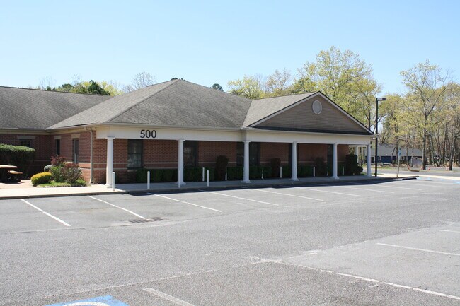
76 W Jimmie Leeds Rd
Atlantic City-Hammonton, NJ
Incl
11-00783-0000-00001
2,3,4,5,6,7,8,76 W PARK CENTRE
Medicalbuilding
Atlantic
ARE
New Jersey
34001C0310F
1
2024
4.26 AC
2025
Atlantic City/Hammonton
010403
Philadelphia
DEMOGRAPHICS near 76 W Jimmie Leeds Rd
1 Mile
3 Mile
5 Mile
2024 Total Population
6,691
21,746
55,583
2029 Population
6,578
21,322
54,438
Pop Growth 2024-2029
(1.69%)
(1.95%)
(2.06%)
Average Age
34
38
41
2024 Total Households
1,351
6,685
19,602
HH Growth 2024-2029
(3.40%)
(2.93%)
(2.91%)
Median Household Inc
$84,025
$76,063
$70,400
Avg Household Size
3.10
2.70
2.60
2024 Avg HH Vehicles
2.00
2.00
2.00
Median Home Value
$216,606
$226,419
$225,023
Median Year Built
1994
1986
1984
Nearby Places
Map Layers
Map Styles
 Street
 Aerial
- Restaurants
- Banks
- Shops
- Fitness
- Groceries
PUBLIC TRANSPORTATION
COMMUTER RAIL
Absecon (Atlantic City Line - NJ Transit Commuter Rail (NJ Transit))
DRIVE
WALK
Distance
Absecon (Atlantic City Line - NJ Transit Commuter Rail (NJ Transit))
7 min
4.9 mi
Egg Harbor City (Atlantic City Line - NJ Transit Commuter Rail (NJ Transit))
DRIVE
WALK
Distance
Egg Harbor City (Atlantic City Line - NJ Transit Commuter Rail (NJ Transit))
11 min
6.9 mi
AIRPORT
Atlantic City International
DRIVE
WALK
Distance
Atlantic City International
30 min
7.5 mi
Freight Ports
Broadway Terminal - Pier 5
DRIVE
WALK
Distance
Broadway Terminal - Pier 5
62 min
46.6 mi
Nearby Properties
Address
Land Use
TOTAL SIZE
Lot Size
Zoning
Address
Land Use
TOTAL SIZE
Lot Size
Zoning
67,752 SF
2,381.05 AC
Address
Land Use
TOTAL SIZE
Lot Size
Zoning
1.57 AC
GI
Address
Land Use
TOTAL SIZE
Lot Size
Zoning
Address
Land Use
TOTAL SIZE
Lot Size
Zoning
16.75 AC
Address
Land Use
TOTAL SIZE
Lot Size
Zoning
2,824 SF
GI
Address
Land Use
TOTAL SIZE
Lot Size
Zoning
27 AC
GI
Address
Land Use
TOTAL SIZE
Lot Size
Zoning
14.32 AC
PO
Address
Land Use
TOTAL SIZE
Lot Size
Zoning
1.74 AC
GI
Address
Land Use
TOTAL SIZE
Lot Size
Zoning
3.66 AC
GI
Address
Land Use
TOTAL SIZE
Lot Size
Zoning
1.89 AC
GI
Address
Land Use
TOTAL SIZE
Lot Size
Zoning
109 AC
NR
Address
Land Use
TOTAL SIZE
Lot Size
Zoning
68.94 AC
NR
Address
Land Use
TOTAL SIZE
Lot Size
Zoning
Address
Land Use
TOTAL SIZE
Lot Size
Zoning
9.96 AC
GI
Address
Land Use
TOTAL SIZE
Lot Size
Zoning
4.50 AC
R-1
Address
Land Use
TOTAL SIZE
Lot Size
Zoning
9.53 AC
PO
Address
Land Use
TOTAL SIZE
Lot Size
Zoning
16.39 AC
R-1
Address
Land Use
TOTAL SIZE
Lot Size
Zoning
14.57 AC
RC
Address
Land Use
TOTAL SIZE
Lot Size
Zoning
65,250 SF
8 AC
CVC
Address
Land Use
TOTAL SIZE
Lot Size
Zoning
3,281 SF
23.91 AC
NR
Address
Land Use
TOTAL SIZE
Lot Size
Zoning
8.67 AC
PO
Address
Land Use
TOTAL SIZE
Lot Size
Zoning
Address
Land Use
TOTAL SIZE
Lot Size
Zoning
Address
Land Use
TOTAL SIZE
Lot Size
Zoning
17.60 AC
R-5
Address
Land Use
TOTAL SIZE
Lot Size
Zoning
Address
Land Use
TOTAL SIZE
Lot Size
Zoning
3.42 AC
CVC
Address
Land Use
TOTAL SIZE
Lot Size
Zoning
831.11 AC
FED
Address
Land Use
TOTAL SIZE
Lot Size
Zoning
Address
Land Use
TOTAL SIZE
Lot Size
Zoning
4.56 AC
PRO
Address
Land Use
TOTAL SIZE
Lot Size
Zoning
2.16 AC
CH
The World's #1 Commercial Real Estate Marketplace
Connect with us
© 2025 CoStar Group
The information above has been obtained from sources believed reliable. While we do not doubt its accuracy we have not verified it and make no guarantee, warranty or representation about it. It is your responsibility to independently confirm its accuracy and completeness. Any projections, opinions, assumptions, or estimates used are for example only and do not represent the current or future performance of the property. The value of this transaction to you depends on tax and other factors which should be evaluated by your tax, financial, and legal advisors. You and your advisors should conduct a careful, independent investigation of the property to determine to your satisfaction the suitability of the property for your needs.