Property Record
760 Bantam Rd, Bantam, CT 06750
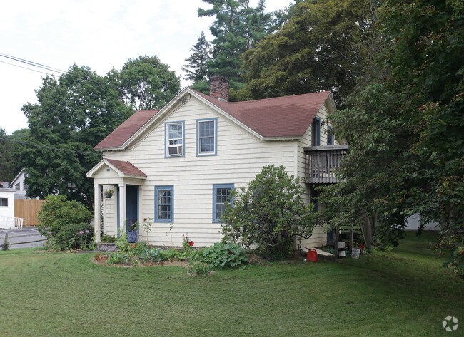

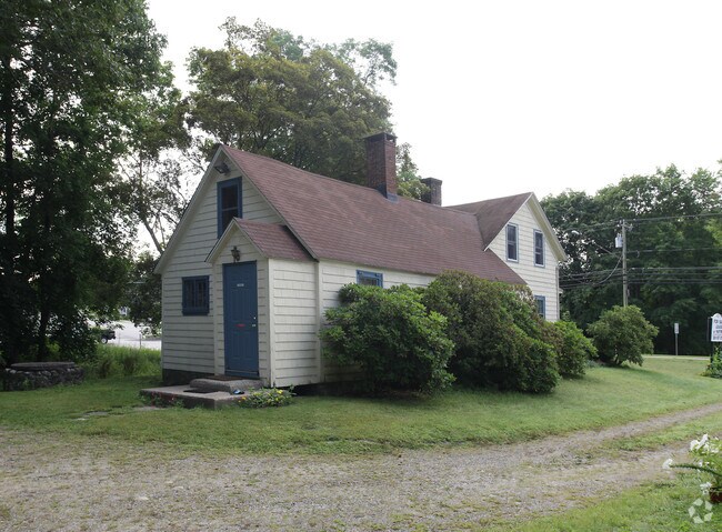
Property Detail
760 Bantam Rd
LITC-000167-000072-000132
Nw Hills
Commercialbuilding
Connecticut
BORO 4
132
2024
2.47 AC
2025
NW Litchfield County
300100
Hartford
1,532 SF
Torrington, CT
NEARBY LISTINGS FOR SALE OR LEASE
DEMOGRAPHICS near 760 Bantam Rd
1 mile
3 mile
5 mile
2024 Total Population
855
4,975
10,072
2029 Population
832
5,034
10,260
Pop Growth 2024-2029
(2.69%)
+ 1.19%
+ 1.87%
Average Age
48
48
47
2024 Total Households
425
2,223
4,268
HH Growth 2024-2029
(2.59%)
+ 1.17%
+ 1.85%
Median Household Inc
$58,999
$98,097
$106,555
Avg Household Size
2.00
2.10
2.20
2024 Avg HH Vehicles
2.00
2.00
2.00
Median Home Value
$304,615
$374,087
$420,270
Median Year Built
1959
1961
1965
Nearby Places
Map Layers
Map Styles
 Street
 Aerial
Transit
 Traffic
 Biking
Places
Listings with unknown addresses are not visible on the map
- Restaurants
- Banks
- Shops
- Fitness
- Groceries
Nearby Properties
Address
Land Use
TOTAL SIZE
Lot Size
Zoning
Address
Land Use
TOTAL SIZE
Lot Size
Zoning
117.77 AC
RR
Address
Land Use
TOTAL SIZE
Lot Size
Zoning
28.27 AC
RR
Address
Land Use
TOTAL SIZE
Lot Size
Zoning
33 AC
RR
Address
Land Use
TOTAL SIZE
Lot Size
Zoning
36,531 SF
3.35 AC
HR20
Address
Land Use
TOTAL SIZE
Lot Size
Zoning
74,534 SF
6.01 AC
C202
Address
Land Use
TOTAL SIZE
Lot Size
Zoning
3,751 SF
59.98 AC
L-8
Address
Land Use
TOTAL SIZE
Lot Size
Zoning
10.92 AC
C202
Address
Land Use
TOTAL SIZE
Lot Size
Zoning
1,123 AC
L-36
Address
Land Use
TOTAL SIZE
Lot Size
Zoning
8.03 AC
C202
Address
Land Use
TOTAL SIZE
Lot Size
Zoning
15,423 SF
0.31 AC
HTC
Address
Land Use
TOTAL SIZE
Lot Size
Zoning
38,604 SF
8.95 AC
BORO 8
Address
Land Use
TOTAL SIZE
Lot Size
Zoning
469.36 AC
RR
Address
Land Use
TOTAL SIZE
Lot Size
Zoning
18.80 AC
L-6
Address
Land Use
TOTAL SIZE
Lot Size
Zoning
2.92 AC
HR30
Address
Land Use
TOTAL SIZE
Lot Size
Zoning
0.98 AC
HR30
Address
Land Use
TOTAL SIZE
Lot Size
Zoning
2.83 AC
HR30
Address
Land Use
TOTAL SIZE
Lot Size
Zoning
6,912 SF
0.36 AC
HR30
Address
Land Use
TOTAL SIZE
Lot Size
Zoning
34,687 SF
3.51 AC
C202
Address
Land Use
TOTAL SIZE
Lot Size
Zoning
26,531 SF
10.56 AC
BORO 8
Address
Land Use
TOTAL SIZE
Lot Size
Zoning
74,142 SF
21.80 AC
L-74
Address
Land Use
TOTAL SIZE
Lot Size
Zoning
1.80 AC
HR30
Address
Land Use
TOTAL SIZE
Lot Size
Zoning
35.70 AC
RR
Address
Land Use
TOTAL SIZE
Lot Size
Zoning
31,917 SF
10.50 AC
C202
Address
Land Use
TOTAL SIZE
Lot Size
Zoning
36,668 SF
2.58 AC
HR20
Address
Land Use
TOTAL SIZE
Lot Size
Zoning
15,876 SF
2.69 AC
BORO 8
Address
Land Use
TOTAL SIZE
Lot Size
Zoning
8.54 AC
RR
Address
Land Use
TOTAL SIZE
Lot Size
Zoning
6 AC
BORO 4
Address
Land Use
TOTAL SIZE
Lot Size
Zoning
26 AC
RR
Address
Land Use
TOTAL SIZE
Lot Size
Zoning
6.50 AC
HR30
Address
Land Use
TOTAL SIZE
Lot Size
Zoning
2.64 AC
HR30
The World's #1 Commercial Real Estate Marketplace
Connect with us
© 2026 CoStar Group
The information above has been obtained from sources believed reliable. While we do not doubt its accuracy we have not verified it and make no guarantee, warranty or representation about it. It is your responsibility to independently confirm its accuracy and completeness. Any projections, opinions, assumptions, or estimates used are for example only and do not represent the current or future performance of the property. The value of this transaction to you depends on tax and other factors which should be evaluated by your tax, financial, and legal advisors. You and your advisors should conduct a careful, independent investigation of the property to determine to your satisfaction the suitability of the property for your needs.