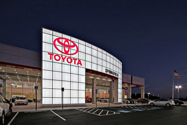
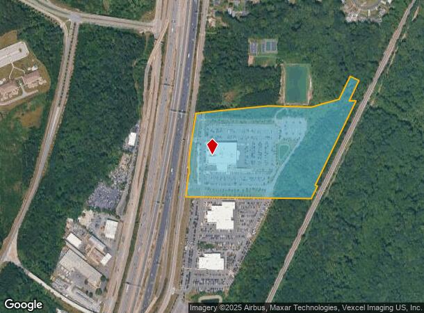
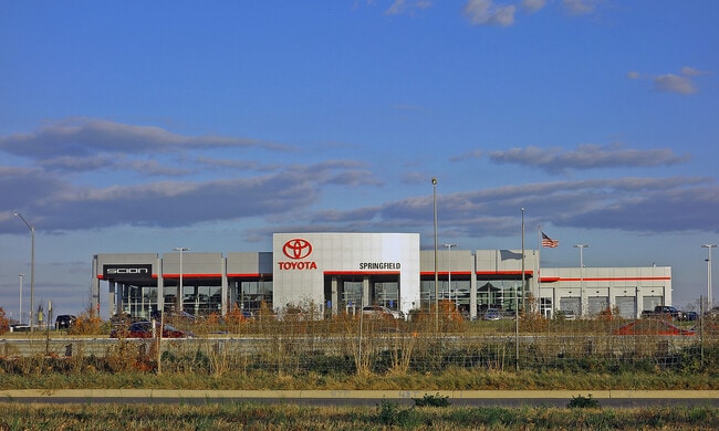
Property Record
7601 Loisdale Rd, Springfield, VA 22150
NEARBY LISTINGS FOR SALE OR LEASE
Property Detail
7601 Loisdale Rd
Washington-Arlington-Alexandria, DC-VA-MD-WV
Jennings Business Park Llc
0904-01-0006A2
JENNINGS BUSINESS PARK LLC PCL 6A2
Vehiclerentalsvehiclesales
Fairfax
X
Virginia
5100540050D
6a
2024
23.14 AC
2025
Springfield/Burke
421002
Washington, DC
86,019 SF
DEMOGRAPHICS near 7601 Loisdale Rd
1 Mile
3 Mile
5 Mile
2024 Total Population
7,518
89,767
282,162
2029 Population
7,378
88,260
277,255
Pop Growth 2024-2029
(1.86%)
(1.68%)
(1.74%)
Average Age
38
41
39
2024 Total Households
2,576
31,627
99,009
HH Growth 2024-2029
(2.06%)
(1.80%)
(1.89%)
Median Household Inc
$131,383
$133,565
$123,852
Avg Household Size
2.80
2.70
2.80
2024 Avg HH Vehicles
2.00
2.00
2.00
Median Home Value
$595,386
$604,626
$588,533
Median Year Built
1988
1983
1980
Nearby Places
Map Layers
Map Styles
 Street
 Aerial
- Restaurants
- Banks
- Shops
- Fitness
- Groceries
PUBLIC TRANSPORTATION
COMMUTER RAIL
Backlick Road (Manassas Line - Virginia Railway Express)
DRIVE
WALK
Distance
Backlick Road (Manassas Line - Virginia Railway Express)
9 min
3.7 mi
Franconia-Springfield (Fredericksburg Line - Virginia Railway Express)
DRIVE
WALK
Distance
Franconia-Springfield (Fredericksburg Line - Virginia Railway Express)
10 min
4.0 mi
AIRPORT
Ronald Reagan Washington Ntl
DRIVE
WALK
Distance
Ronald Reagan Washington Ntl
22 min
12.4 mi
Washington Dulles International
DRIVE
WALK
Distance
Washington Dulles International
46 min
29.0 mi
Freight Ports
Port of Baltimore
DRIVE
WALK
Distance
Port of Baltimore
81 min
53.6 mi
SALE & LEASE HISTORY
LISTING DATE
SALE/LEASE

Aug 31, 2023
For Sale
Nearby Properties
Address
Land Use
TOTAL SIZE
Lot Size
Zoning
Address
Land Use
TOTAL SIZE
Lot Size
Zoning
717,618 SF
16.81 AC
340
Address
Land Use
TOTAL SIZE
Lot Size
Zoning
824,193 SF
16.06 AC
400
Address
Land Use
TOTAL SIZE
Lot Size
Zoning
631,189 SF
9.48 AC
497
Address
Land Use
TOTAL SIZE
Lot Size
Zoning
2,239,442 SF
58.08 AC
130
Address
Land Use
TOTAL SIZE
Lot Size
Zoning
480,165 SF
21.23 AC
304
Address
Land Use
TOTAL SIZE
Lot Size
Zoning
73,835 SF
27.26 AC
540
Address
Land Use
TOTAL SIZE
Lot Size
Zoning
1,286,047 SF
69.60 AC
540
Address
Land Use
TOTAL SIZE
Lot Size
Zoning
338,106 SF
26.50 AC
304
Address
Land Use
TOTAL SIZE
Lot Size
Zoning
226,270 SF
21.98 AC
400
Address
Land Use
TOTAL SIZE
Lot Size
Zoning
187,773 SF
23.18 AC
304
Address
Land Use
TOTAL SIZE
Lot Size
Zoning
452,682 SF
20.74 AC
220
Address
Land Use
TOTAL SIZE
Lot Size
Zoning
394,657 SF
10.47 AC
340
Address
Land Use
TOTAL SIZE
Lot Size
Zoning
357,064 SF
19.14 AC
540
Address
Land Use
TOTAL SIZE
Lot Size
Zoning
1,000 SF
23.41 AC
550
Address
Land Use
TOTAL SIZE
Lot Size
Zoning
327,600 SF
12.31 AC
304
Address
Land Use
TOTAL SIZE
Lot Size
Zoning
726,779 SF
57.50 AC
130
Address
Land Use
TOTAL SIZE
Lot Size
Zoning
633,133 SF
39.97 AC
150
Address
Land Use
TOTAL SIZE
Lot Size
Zoning
374,125 SF
2.84 AC
400
Address
Land Use
TOTAL SIZE
Lot Size
Zoning
114,205 SF
14.06 AC
497
Address
Land Use
TOTAL SIZE
Lot Size
Zoning
164,037 SF
21.72 AC
550
Address
Land Use
TOTAL SIZE
Lot Size
Zoning
171,711 SF
16.08 AC
480
Address
Land Use
TOTAL SIZE
Lot Size
Zoning
270,191 SF
1.83 AC
440
Address
Land Use
TOTAL SIZE
Lot Size
Zoning
188,000 SF
4.54 AC
400
Address
Land Use
TOTAL SIZE
Lot Size
Zoning
106,170 SF
8.39 AC
460
Address
Land Use
TOTAL SIZE
Lot Size
Zoning
94,712 SF
8.44 AC
304
Address
Land Use
TOTAL SIZE
Lot Size
Zoning
256,400 SF
16.85 AC
560
Address
Land Use
TOTAL SIZE
Lot Size
Zoning
160,788 SF
6.36 AC
304
Address
Land Use
TOTAL SIZE
Lot Size
Zoning
245,038 SF
9.28 AC
540
Address
Land Use
TOTAL SIZE
Lot Size
Zoning
176,211 SF
8.04 AC
220
The World's #1 Commercial Real Estate Marketplace
Connect with us
© 2025 CoStar Group
The information above has been obtained from sources believed reliable. While we do not doubt its accuracy we have not verified it and make no guarantee, warranty or representation about it. It is your responsibility to independently confirm its accuracy and completeness. Any projections, opinions, assumptions, or estimates used are for example only and do not represent the current or future performance of the property. The value of this transaction to you depends on tax and other factors which should be evaluated by your tax, financial, and legal advisors. You and your advisors should conduct a careful, independent investigation of the property to determine to your satisfaction the suitability of the property for your needs.