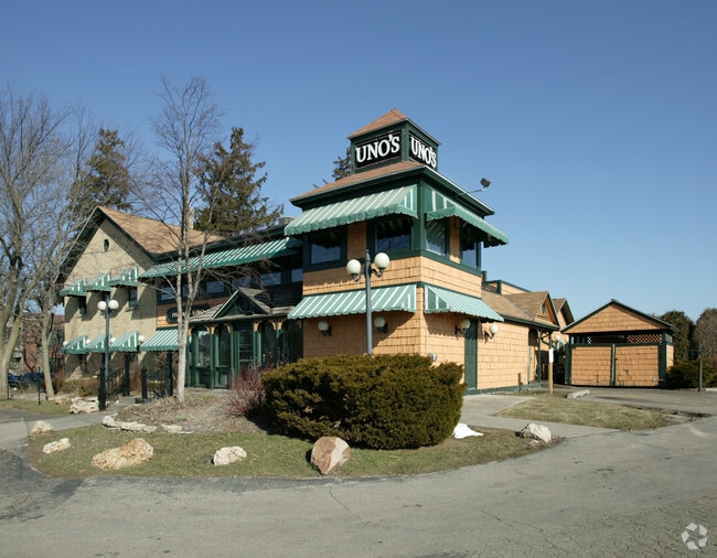
Property Record
7603 Mineral Point Rd, Madison, WI 53717

NEARBY LISTINGS FOR SALE OR LEASE
Property Detail
7603 Mineral Point Rd
Madison, WI
Highpoint Commercial
0708-262-0302-1
HIGHPOINT COMMERCIAL, LOT 2.
Commercialnec
Dane
X
Wisconsin
55025C0395G
2
2024
1.07 AC
2024
Southwest Madison
000410
Milwaukee/Madison
2,300 SF
DEMOGRAPHICS near 7603 Mineral Point Rd
1 Mile
3 Mile
5 Mile
2024 Total Population
12,644
84,838
164,634
2029 Population
13,294
88,410
171,007
Pop Growth 2024-2029
+ 5.14%
+ 4.21%
+ 3.87%
Average Age
39
40
39
2024 Total Households
6,553
39,174
73,094
HH Growth 2024-2029
+ 5.10%
+ 4.34%
+ 3.98%
Median Household Inc
$70,345
$87,218
$89,682
Avg Household Size
1.90
2.10
2.20
2024 Avg HH Vehicles
1.00
2.00
2.00
Median Home Value
$383,541
$376,350
$389,607
Median Year Built
1990
1989
1986
Nearby Places
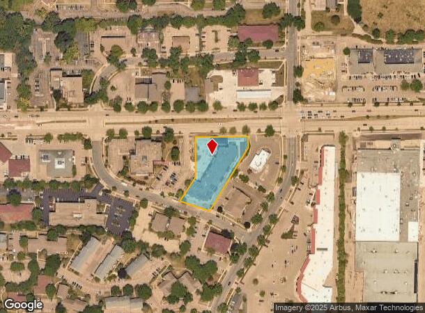
Map Layers
Map Styles
 Street
 Aerial
- Restaurants
- Banks
- Shops
- Fitness
- Groceries
PUBLIC TRANSPORTATION
AIRPORT
Dane County Regional/Truax Field
DRIVE
WALK
Distance
Dane County Regional/Truax Field
27 min
16.7 mi
Freight Ports
Port Milwaukee
DRIVE
WALK
Distance
Port Milwaukee
109 min
90.5 mi
SALE & LEASE HISTORY
LISTING DATE
SALE/LEASE

Sep 24, 2016
For Sale
Jul 03, 2018
For Lease
Jul 03, 2018
For Sale
Apr 23, 2018
For Lease
Nearby Properties
Address
Land Use
TOTAL SIZE
Lot Size
Zoning
Address
Land Use
TOTAL SIZE
Lot Size
Zoning
82,796 SF
9.26 AC
SE
Address
Land Use
TOTAL SIZE
Lot Size
Zoning
69,336 SF
26.90 AC
SE
Address
Land Use
TOTAL SIZE
Lot Size
Zoning
354,461 SF
37.40 AC
RMX
Address
Land Use
TOTAL SIZE
Lot Size
Zoning
15.61 AC
Address
Land Use
TOTAL SIZE
Lot Size
Zoning
700,496 SF
23.94 AC
SR-V2
Address
Land Use
TOTAL SIZE
Lot Size
Zoning
56,000 SF
23.87 AC
SE
Address
Land Use
TOTAL SIZE
Lot Size
Zoning
37,909 SF
10.27 AC
SEC
Address
Land Use
TOTAL SIZE
Lot Size
Zoning
203,672 SF
7.34 AC
PD
Address
Land Use
TOTAL SIZE
Lot Size
Zoning
349,680 SF
6.28 AC
TR-U2
Address
Land Use
TOTAL SIZE
Lot Size
Zoning
420,780 SF
10.14 AC
PD
Address
Land Use
TOTAL SIZE
Lot Size
Zoning
1.44 AC
TE
Address
Land Use
TOTAL SIZE
Lot Size
Zoning
169,563 SF
19.82 AC
SEC
Address
Land Use
TOTAL SIZE
Lot Size
Zoning
51,205 SF
9.32 AC
SE
Address
Land Use
TOTAL SIZE
Lot Size
Zoning
27,201 SF
7.65 AC
TR-U2
Address
Land Use
TOTAL SIZE
Lot Size
Zoning
467,400 SF
6.17 AC
TR-U2
Address
Land Use
TOTAL SIZE
Lot Size
Zoning
5.95 AC
Address
Land Use
TOTAL SIZE
Lot Size
Zoning
27,201 SF
10.08 AC
TR-U2
Address
Land Use
TOTAL SIZE
Lot Size
Zoning
11.09 AC
Address
Land Use
TOTAL SIZE
Lot Size
Zoning
161,767 SF
4.58 AC
CC-T
Address
Land Use
TOTAL SIZE
Lot Size
Zoning
2.91 AC
SE
Address
Land Use
TOTAL SIZE
Lot Size
Zoning
290,535 SF
11.25 AC
PD
Address
Land Use
TOTAL SIZE
Lot Size
Zoning
4.05 AC
CC-T
Address
Land Use
TOTAL SIZE
Lot Size
Zoning
326,724 SF
4.23 AC
PD
Address
Land Use
TOTAL SIZE
Lot Size
Zoning
311,672 SF
4.59 AC
PD
Address
Land Use
TOTAL SIZE
Lot Size
Zoning
254,922 SF
11.97 AC
PD
Address
Land Use
TOTAL SIZE
Lot Size
Zoning
324,920 SF
8.47 AC
PD
Address
Land Use
TOTAL SIZE
Lot Size
Zoning
159,686 SF
7.39 AC
SEC
Address
Land Use
TOTAL SIZE
Lot Size
Zoning
Address
Land Use
TOTAL SIZE
Lot Size
Zoning
4.37 AC
Address
Land Use
TOTAL SIZE
Lot Size
Zoning
The World's #1 Commercial Real Estate Marketplace
Connect with us
© 2025 CoStar Group
The information above has been obtained from sources believed reliable. While we do not doubt its accuracy we have not verified it and make no guarantee, warranty or representation about it. It is your responsibility to independently confirm its accuracy and completeness. Any projections, opinions, assumptions, or estimates used are for example only and do not represent the current or future performance of the property. The value of this transaction to you depends on tax and other factors which should be evaluated by your tax, financial, and legal advisors. You and your advisors should conduct a careful, independent investigation of the property to determine to your satisfaction the suitability of the property for your needs.