Property Record
7602 Dick Price Rd, Mansfield, TX 76063

Property Detail
7602 Dick Price Rd
Dallas-Fort Worth-Arlington, TX
BAKER, JOSEPH SURVEY ABSTRACT 214 TRACT 2J01
05836018
TARRANT
Residentialacreage
Texas
B and X Area of moderate flood hazard, usually the area between the limits of the 100-year and 500-year floods.
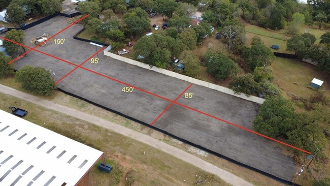
0.67 AC
2023
Southeast Ft Worth
2025
Dallas/Ft Worth
111318
NEARBY LISTINGS FOR SALE OR LEASE
DEMOGRAPHICS near 7602 Dick Price Rd
1 mile
3 mile
5 mile
2025 Total Population
1,643
33,062
135,214
2030 Population
1,759
35,176
142,593
Pop Growth 2025-2030
+ 7.06%
+ 6.39%
+ 5.46%
Average Age
41
39
39
2025 Total Households
556
11,369
47,195
HH Growth 2025-2030
+ 7.19%
+ 6.54%
+ 5.62%
Median Household Inc
$104,775
$106,810
$99,283
Avg Household Size
2.90
2.90
2.80
2025 Avg HH Vehicles
2.00
2.00
2.00
Median Home Value
$394,879
$427,905
$361,258
Median Year Built
2001
2001
1994
Nearby Places
Map Layers
Map Styles
 Street
 Aerial
Transit
 Traffic
 Biking
Places
Listings with unknown addresses are not visible on the map
- Restaurants
- Banks
- Shops
- Fitness
- Groceries
PUBLIC TRANSPORTATION
AIRPORT
Dallas-Fort Worth International
Drive
Walk
Distance
Dallas-Fort Worth International
46 min
32.0 mi
Dallas Love Field
Drive
Walk
Distance
Dallas Love Field
55 min
39.3 mi
Freight Ports
Port of Shreveport
Drive
Walk
Distance
Port of Shreveport
246 min
225.0 mi
SALE & LEASE HISTORY
LISTING DATE
SALE/LEASE

Oct 24, 2025
For Lease
Nearby Properties
Address
Land Use
TOTAL SIZE
Lot Size
Zoning
Address
Land Use
TOTAL SIZE
Lot Size
Zoning
160,000 SF
26.90 AC
Address
Land Use
TOTAL SIZE
Lot Size
Zoning
256,088 SF
10.27 AC
Address
Land Use
TOTAL SIZE
Lot Size
Zoning
170,082 SF
36.49 AC
Address
Land Use
TOTAL SIZE
Lot Size
Zoning
214,444 SF
17.45 AC
Address
Land Use
TOTAL SIZE
Lot Size
Zoning
231,551 SF
25.69 AC
Address
Land Use
TOTAL SIZE
Lot Size
Zoning
169,347 SF
13.92 AC
Address
Land Use
TOTAL SIZE
Lot Size
Zoning
229,168 SF
6.13 AC
Address
Land Use
TOTAL SIZE
Lot Size
Zoning
79,070 SF
11.98 AC
Address
Land Use
TOTAL SIZE
Lot Size
Zoning
268,603 SF
12.45 AC
Address
Land Use
TOTAL SIZE
Lot Size
Zoning
238,119 SF
7.52 AC
Address
Land Use
TOTAL SIZE
Lot Size
Zoning
81,540 SF
11.89 AC
Address
Land Use
TOTAL SIZE
Lot Size
Zoning
80,907 SF
29 AC
Address
Land Use
TOTAL SIZE
Lot Size
Zoning
44,669 SF
9.05 AC
Address
Land Use
TOTAL SIZE
Lot Size
Zoning
77,884 SF
30.70 AC
Address
Land Use
TOTAL SIZE
Lot Size
Zoning
127,690 SF
37.21 AC
Address
Land Use
TOTAL SIZE
Lot Size
Zoning
22.84 AC
Address
Land Use
TOTAL SIZE
Lot Size
Zoning
156,103 SF
4.42 AC
Address
Land Use
TOTAL SIZE
Lot Size
Zoning
41,960 SF
13.70 AC
Address
Land Use
TOTAL SIZE
Lot Size
Zoning
143,210 SF
9.78 AC
Address
Land Use
TOTAL SIZE
Lot Size
Zoning
143,104 SF
7.75 AC
Address
Land Use
TOTAL SIZE
Lot Size
Zoning
76,715 SF
7.98 AC
Address
Land Use
TOTAL SIZE
Lot Size
Zoning
1,008 SF
20.48 AC
Address
Land Use
TOTAL SIZE
Lot Size
Zoning
108,708 SF
16.64 AC
Address
Land Use
TOTAL SIZE
Lot Size
Zoning
112,110 SF
14.64 AC
Address
Land Use
TOTAL SIZE
Lot Size
Zoning
38,400 SF
43.84 AC
Address
Land Use
TOTAL SIZE
Lot Size
Zoning
2,088 SF
19.19 AC
Address
Land Use
TOTAL SIZE
Lot Size
Zoning
50,000 SF
17.96 AC
Address
Land Use
TOTAL SIZE
Lot Size
Zoning
107,055 SF
9.92 AC
Address
Land Use
TOTAL SIZE
Lot Size
Zoning
191,419 SF
19.10 AC
Address
Land Use
TOTAL SIZE
Lot Size
Zoning
73,145 SF
9.97 AC
The World's #1 Commercial Real Estate Marketplace
Connect with us
© 2026 CoStar Group
The information above has been obtained from sources believed reliable. While we do not doubt its accuracy we have not verified it and make no guarantee, warranty or representation about it. It is your responsibility to independently confirm its accuracy and completeness. Any projections, opinions, assumptions, or estimates used are for example only and do not represent the current or future performance of the property. The value of this transaction to you depends on tax and other factors which should be evaluated by your tax, financial, and legal advisors. You and your advisors should conduct a careful, independent investigation of the property to determine to your satisfaction the suitability of the property for your needs.