Property Record
7607 Nc Highway 68 N, Oak Ridge, NC 27310
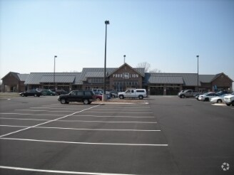


Property Detail
7607 Nc Highway 68 N
0163665
KINGS CROSSING SHOP CNTR/HWY 68 N LO:1 PL:175-25
Commercialnec
Guilford
CD-HB
North Carolina
B and X Area of moderate flood hazard, usually the area between the limits of the 100-year and 500-year floods.
1
2024
23.39 AC
2025
NW Guilford County
015902
Greensboro/Winston-Salem
50,853 SF
Greensboro-High Point, NC
NEARBY LISTINGS FOR SALE OR LEASE
DEMOGRAPHICS near 7607 Nc Highway 68 N
1 mile
3 mile
5 mile
2025 Total Population
1,831
10,945
26,700
2030 Population
1,918
11,403
27,837
Pop Growth 2025-2030
+ 4.75%
+ 4.18%
+ 4.26%
Average Age
40
41
41
2025 Total Households
633
3,857
9,632
HH Growth 2025-2030
+ 4.90%
+ 4.30%
+ 4.39%
Median Household Inc
$157,467
$135,611
$118,709
Avg Household Size
2.90
2.80
2.80
2025 Avg HH Vehicles
3.00
3.00
3.00
Median Home Value
$493,157
$475,790
$455,251
Median Year Built
2000
1998
1996
Nearby Places
Map Layers
Map Styles
 Street
 Aerial
Layers
 Traffic
 Biking
Places
Listings with unknown addresses are not visible on the map
- Restaurants
- Banks
- Shops
- Fitness
- Groceries
PUBLIC TRANSPORTATION
AIRPORT
Piedmont Triad International
Drive
Walk
Distance
Piedmont Triad International
24 min
13.6 mi
Freight Ports
Virginia Port Authority - Richmond
Drive
Walk
Distance
Virginia Port Authority - Richmond
249 min
190.4 mi
Nearby Properties
Address
Land Use
TOTAL SIZE
Lot Size
Zoning
Address
Land Use
TOTAL SIZE
Lot Size
Zoning
169,401 SF
30.89 AC
PI
Address
Land Use
TOTAL SIZE
Lot Size
Zoning
516,172 SF
58.24 AC
LI
Address
Land Use
TOTAL SIZE
Lot Size
Zoning
100,320 SF
13.16 AC
SC
Address
Land Use
TOTAL SIZE
Lot Size
Zoning
516,221 SF
106.85 AC
AG
Address
Land Use
TOTAL SIZE
Lot Size
Zoning
121,825 SF
36.43 AC
GO-M
Address
Land Use
TOTAL SIZE
Lot Size
Zoning
25,755 SF
509.95 AC
AG
Address
Land Use
TOTAL SIZE
Lot Size
Zoning
0.77 AC
CU-SC
Address
Land Use
TOTAL SIZE
Lot Size
Zoning
55,958 SF
5.82 AC
PI
Address
Land Use
TOTAL SIZE
Lot Size
Zoning
21,768 SF
3.06 AC
CU-SC
Address
Land Use
TOTAL SIZE
Lot Size
Zoning
20,418 SF
31.84 AC
PI
Address
Land Use
TOTAL SIZE
Lot Size
Zoning
16,445 SF
2.69 AC
CU-GO-M
Address
Land Use
TOTAL SIZE
Lot Size
Zoning
26,410 SF
5.06 AC
GB
Address
Land Use
TOTAL SIZE
Lot Size
Zoning
8,336 SF
4.01 AC
CU-LB
Address
Land Use
TOTAL SIZE
Lot Size
Zoning
5,761 SF
39.01 AC
PI
Address
Land Use
TOTAL SIZE
Lot Size
Zoning
10,820 SF
1.95 AC
CU-GB
Address
Land Use
TOTAL SIZE
Lot Size
Zoning
4,692 SF
1.17 AC
CU-SC
Address
Land Use
TOTAL SIZE
Lot Size
Zoning
3,715 SF
1.34 AC
CU-GO-M
Address
Land Use
TOTAL SIZE
Lot Size
Zoning
66.19 AC
PI
Address
Land Use
TOTAL SIZE
Lot Size
Zoning
8,774 SF
2.07 AC
HB
Address
Land Use
TOTAL SIZE
Lot Size
Zoning
4,237 SF
10.82 AC
GO-M
Address
Land Use
TOTAL SIZE
Lot Size
Zoning
3,594 SF
1.15 AC
SC
Address
Land Use
TOTAL SIZE
Lot Size
Zoning
13,872 SF
1.96 AC
GO-M
Address
Land Use
TOTAL SIZE
Lot Size
Zoning
16,640 SF
4.20 AC
HB
Address
Land Use
TOTAL SIZE
Lot Size
Zoning
9,287 SF
1.66 AC
CU-SC
Address
Land Use
TOTAL SIZE
Lot Size
Zoning
4,398 SF
76.58 AC
AG
Address
Land Use
TOTAL SIZE
Lot Size
Zoning
7,403 SF
3.36 AC
GO-M
Address
Land Use
TOTAL SIZE
Lot Size
Zoning
14,350 SF
1.45 AC
LB
Address
Land Use
TOTAL SIZE
Lot Size
Zoning
12,496 SF
7.65 AC
RS-30
Address
Land Use
TOTAL SIZE
Lot Size
Zoning
11,763 SF
5.65 AC
RS-30
The World's #1 Commercial Real Estate Marketplace
Connect with us
© 2026 CoStar Group
The information above has been obtained from sources believed reliable. While we do not doubt its accuracy we have not verified it and make no guarantee, warranty or representation about it. It is your responsibility to independently confirm its accuracy and completeness. Any projections, opinions, assumptions, or estimates used are for example only and do not represent the current or future performance of the property. The value of this transaction to you depends on tax and other factors which should be evaluated by your tax, financial, and legal advisors. You and your advisors should conduct a careful, independent investigation of the property to determine to your satisfaction the suitability of the property for your needs.