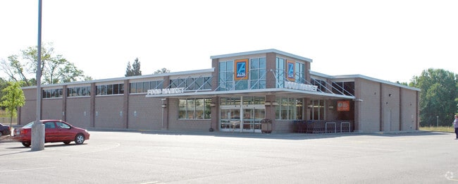
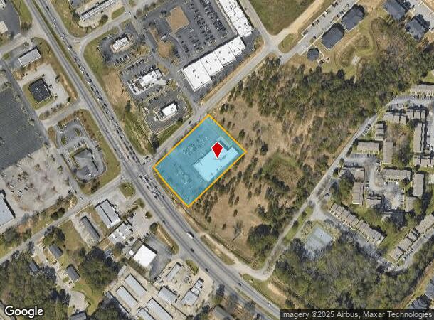
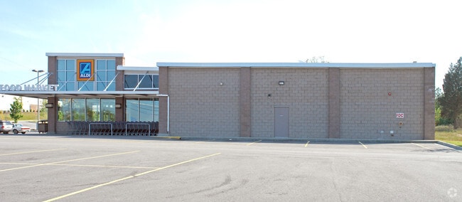
Property Record
7610 Garners Ferry Rd, Columbia, SC 29209
NEARBY LISTINGS FOR SALE OR LEASE
Property Detail
7610 Garners Ferry Rd
16315-02-06
Garners Ferry
Commercialnec
240.5X346.1X239.9X369.8 #SU #PR RB844-1073/1074
X
Richland
45079C0379L
South Carolina
2025
1.99 AC
2024
Southeast Columbia
011608
Columbia
16,302 SF
Columbia, SC
DEMOGRAPHICS near 7610 Garners Ferry Rd
1 Mile
3 Mile
5 Mile
2024 Total Population
8,409
41,080
87,845
2029 Population
8,583
41,448
89,524
Pop Growth 2024-2029
+ 2.07%
+ 0.90%
+ 1.91%
Average Age
35
36
36
2024 Total Households
3,815
14,667
35,299
HH Growth 2024-2029
+ 2.07%
+ 1.04%
+ 2.14%
Median Household Inc
$51,614
$56,302
$57,046
Avg Household Size
2.20
2.20
2.20
2024 Avg HH Vehicles
2.00
2.00
2.00
Median Home Value
$150,594
$183,485
$224,072
Median Year Built
1997
1983
1978
Nearby Places
Map Layers
Map Styles
 Street
 Aerial
- Restaurants
- Banks
- Shops
- Fitness
- Groceries
PUBLIC TRANSPORTATION
COMMUTER RAIL
DRIVE
WALK
Distance
15 min
7.4 mi
AIRPORT
Columbia Metro
DRIVE
WALK
Distance
Columbia Metro
28 min
16.7 mi
Nearby Properties
Address
Land Use
TOTAL SIZE
Lot Size
Zoning
Address
Land Use
TOTAL SIZE
Lot Size
Zoning
460,078 SF
42.80 AC
M-1
Address
Land Use
TOTAL SIZE
Lot Size
Zoning
316,116 SF
21.73 AC
RG-2
Address
Land Use
TOTAL SIZE
Lot Size
Zoning
241,878 SF
14.03 AC
C-3
Address
Land Use
TOTAL SIZE
Lot Size
Zoning
3,000 SF
52.49 AC
O-I
Address
Land Use
TOTAL SIZE
Lot Size
Zoning
95.26 AC
C-1
Address
Land Use
TOTAL SIZE
Lot Size
Zoning
216,180 SF
15.66 AC
C-1
Address
Land Use
TOTAL SIZE
Lot Size
Zoning
230,053 SF
18.35 AC
C-3
Address
Land Use
TOTAL SIZE
Lot Size
Zoning
32,640 SF
23.73 AC
RSF-2
Address
Land Use
TOTAL SIZE
Lot Size
Zoning
294,105 SF
19 AC
RG-2
Address
Land Use
TOTAL SIZE
Lot Size
Zoning
212,787 SF
26.93 AC
C-3
Address
Land Use
TOTAL SIZE
Lot Size
Zoning
281,304 SF
22.86 AC
RG-2
Address
Land Use
TOTAL SIZE
Lot Size
Zoning
285,760 SF
16.12 AC
RG-2
Address
Land Use
TOTAL SIZE
Lot Size
Zoning
62,250 SF
8.15 AC
GC
Address
Land Use
TOTAL SIZE
Lot Size
Zoning
199,263 SF
18.29 AC
C-3
Address
Land Use
TOTAL SIZE
Lot Size
Zoning
160,954 SF
24.03 AC
C-3
Address
Land Use
TOTAL SIZE
Lot Size
Zoning
247,744 SF
15.32 AC
RM-HD
Address
Land Use
TOTAL SIZE
Lot Size
Zoning
59,864 SF
24.97 AC
M-1
Address
Land Use
TOTAL SIZE
Lot Size
Zoning
129,820 SF
11.12 AC
HI
Address
Land Use
TOTAL SIZE
Lot Size
Zoning
125,486 SF
9.97 AC
C-3
Address
Land Use
TOTAL SIZE
Lot Size
Zoning
68,216 SF
1.84 AC
C-3
Address
Land Use
TOTAL SIZE
Lot Size
Zoning
89,639 SF
14.68 AC
C-3
Address
Land Use
TOTAL SIZE
Lot Size
Zoning
97,324 SF
9.29 AC
C-3
Address
Land Use
TOTAL SIZE
Lot Size
Zoning
297,892 SF
10.99 AC
M-2
Address
Land Use
TOTAL SIZE
Lot Size
Zoning
183,098 SF
13.04 AC
RG-2
Address
Land Use
TOTAL SIZE
Lot Size
Zoning
107,824 SF
7.93 AC
R-3
Address
Land Use
TOTAL SIZE
Lot Size
Zoning
68,012 SF
13.18 AC
M-1
Address
Land Use
TOTAL SIZE
Lot Size
Zoning
140,100 SF
7.12 AC
M-2
Address
Land Use
TOTAL SIZE
Lot Size
Zoning
51,000 SF
6.25 AC
C-3
Address
Land Use
TOTAL SIZE
Lot Size
Zoning
57,465 SF
5.63 AC
C-3
Address
Land Use
TOTAL SIZE
Lot Size
Zoning
180,828 SF
17.24 AC
RSF-3
The World's #1 Commercial Real Estate Marketplace
Connect with us
© 2025 CoStar Group
The information above has been obtained from sources believed reliable. While we do not doubt its accuracy we have not verified it and make no guarantee, warranty or representation about it. It is your responsibility to independently confirm its accuracy and completeness. Any projections, opinions, assumptions, or estimates used are for example only and do not represent the current or future performance of the property. The value of this transaction to you depends on tax and other factors which should be evaluated by your tax, financial, and legal advisors. You and your advisors should conduct a careful, independent investigation of the property to determine to your satisfaction the suitability of the property for your needs.