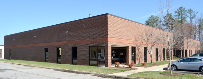
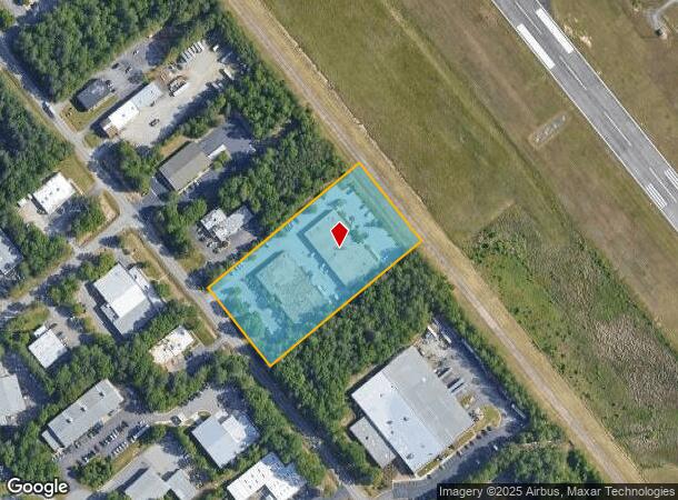
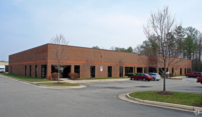
Property Record
7610 Whitepine Rd, North Chesterfield, VA 23237
NEARBY LISTINGS FOR SALE OR LEASE
Property Detail
7610 Whitepine Rd
766-67-15-41-100-000
Chfld Airport Industrial Park
Industrialgeneral
CHFLD AIRPORT INDUSTRIAL PARK
X
Chesterfield
5101290075E
Virginia
2025
3.66 AC
2025
Rt 288 Corridor
100820
Richmond VA
21,100 SF
Richmond, VA
DEMOGRAPHICS near 7610 Whitepine Rd
1 Mile
3 Mile
5 Mile
2024 Total Population
129
32,368
108,809
2029 Population
141
35,378
119,047
Pop Growth 2024-2029
+ 9.30%
+ 9.30%
+ 9.41%
Average Age
43
39
40
2024 Total Households
46
11,427
40,138
HH Growth 2024-2029
+ 8.70%
+ 9.43%
+ 9.57%
Median Household Inc
$79,167
$81,330
$72,331
Avg Household Size
2.60
2.70
2.60
2024 Avg HH Vehicles
3.00
2.00
2.00
Median Home Value
$276,666
$258,020
$264,048
Median Year Built
1979
1987
1987
Nearby Places
Map Layers
Map Styles
 Street
 Aerial
- Restaurants
- Banks
- Shops
- Fitness
- Groceries
PUBLIC TRANSPORTATION
AIRPORT
Richmond International
DRIVE
WALK
Distance
Richmond International
32 min
18.8 mi
Nearby Properties
Address
Land Use
TOTAL SIZE
Lot Size
Zoning
Address
Land Use
TOTAL SIZE
Lot Size
Zoning
387,548 SF
16.18 AC
C3 - COMMU
Address
Land Use
TOTAL SIZE
Lot Size
Zoning
5.61 AC
A - AGRICU
Address
Land Use
TOTAL SIZE
Lot Size
Zoning
278,193 SF
74.49 AC
A - AGRICU
Address
Land Use
TOTAL SIZE
Lot Size
Zoning
95,419 SF
21.13 AC
RMF - RES,
Address
Land Use
TOTAL SIZE
Lot Size
Zoning
12.42 AC
RTH - RES,
Address
Land Use
TOTAL SIZE
Lot Size
Zoning
613,315 SF
12.94 AC
I1 - LT IN
Address
Land Use
TOTAL SIZE
Lot Size
Zoning
16,052 SF
552.02 AC
I1 - LT IN
Address
Land Use
TOTAL SIZE
Lot Size
Zoning
99,934 SF
27.15 AC
A - AGRICU
Address
Land Use
TOTAL SIZE
Lot Size
Zoning
8,432 SF
65.59 AC
A - AGRICU
Address
Land Use
TOTAL SIZE
Lot Size
Zoning
100 SF
10.98 AC
R7 - SINGL
Address
Land Use
TOTAL SIZE
Lot Size
Zoning
65,261 SF
64.31 AC
A - AGRICU
Address
Land Use
TOTAL SIZE
Lot Size
Zoning
119,527 SF
14.89 AC
C5 - GEN B
Address
Land Use
TOTAL SIZE
Lot Size
Zoning
40,729 SF
22.64 AC
A - AGRICU
Address
Land Use
TOTAL SIZE
Lot Size
Zoning
22,151 SF
48.28 AC
A - AGRICU
Address
Land Use
TOTAL SIZE
Lot Size
Zoning
138,787 SF
21.46 AC
A - AGRICU
Address
Land Use
TOTAL SIZE
Lot Size
Zoning
100 SF
10.21 AC
R7 - SINGL
Address
Land Use
TOTAL SIZE
Lot Size
Zoning
53,100 SF
37.74 AC
O2 - CORP
Address
Land Use
TOTAL SIZE
Lot Size
Zoning
91,100 SF
18.74 AC
A - AGRICU
Address
Land Use
TOTAL SIZE
Lot Size
Zoning
99,471 SF
19.26 AC
A - AGRICU
Address
Land Use
TOTAL SIZE
Lot Size
Zoning
20,312 SF
12.76 AC
A - AGRICU
Address
Land Use
TOTAL SIZE
Lot Size
Zoning
78,948 SF
0.63 AC
A - AGRICU
Address
Land Use
TOTAL SIZE
Lot Size
Zoning
92,000 SF
5.41 AC
C5 - GEN B
Address
Land Use
TOTAL SIZE
Lot Size
Zoning
68,933 SF
19.84 AC
A - AGRICU
Address
Land Use
TOTAL SIZE
Lot Size
Zoning
7,072 SF
13.53 AC
A - AGRICU
Address
Land Use
TOTAL SIZE
Lot Size
Zoning
91,010 SF
18.36 AC
I1 - LT IN
Address
Land Use
TOTAL SIZE
Lot Size
Zoning
61,000 SF
2.09 AC
O2 - CORP
Address
Land Use
TOTAL SIZE
Lot Size
Zoning
336 SF
191.77 AC
A - AGRICU
Address
Land Use
TOTAL SIZE
Lot Size
Zoning
108,000 SF
9.15 AC
I1 - LT IN
Address
Land Use
TOTAL SIZE
Lot Size
Zoning
127,140 SF
22.84 AC
A - AGRICU
Address
Land Use
TOTAL SIZE
Lot Size
Zoning
28,150 SF
6.54 AC
A - AGRICU
The World's #1 Commercial Real Estate Marketplace
Connect with us
© 2026 CoStar Group
The information above has been obtained from sources believed reliable. While we do not doubt its accuracy we have not verified it and make no guarantee, warranty or representation about it. It is your responsibility to independently confirm its accuracy and completeness. Any projections, opinions, assumptions, or estimates used are for example only and do not represent the current or future performance of the property. The value of this transaction to you depends on tax and other factors which should be evaluated by your tax, financial, and legal advisors. You and your advisors should conduct a careful, independent investigation of the property to determine to your satisfaction the suitability of the property for your needs.