Property Record
7612 E Route 20, Westfield, NY 14787

Save to a Folder
{{folder.Name}}
{{folder.ListingIds.length}} Properties
{{folder.ListingIds.length}} Property
Create a New Folder
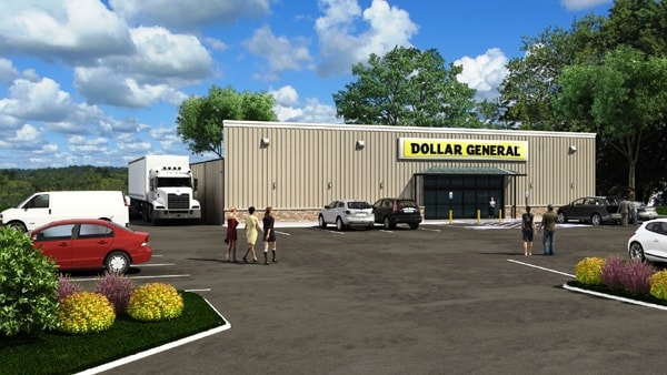
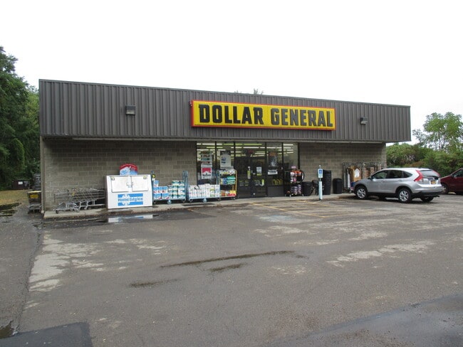
Property Detail
7612 E Route 20
Jamestown-Dunkirk, NY
OLD APN: 067289 3-1-9.2
067289-193-000-0001-039-002
Chautauqua
Storebuilding
New York
C
39.002
2025
1 AC
2025
New York West Area
036500
Other Market Areas
8,125 SF
NEARBY LISTINGS FOR SALE OR LEASE
-
-
View all Westfield listings for sale on LoopNet.com
DEMOGRAPHICS near 7612 E Route 20
1 mile
3 mile
5 mile
2025 Total Population
438
3,945
5,163
2030 Population
427
3,880
5,106
Pop Growth 2025-2030
(2.51%)
(1.65%)
(1.10%)
Average Age
46
46
46
2025 Total Households
194
1,733
2,243
HH Growth 2025-2030
(3.09%)
(1.90%)
(1.38%)
Median Household Inc
$46,551
$47,590
$49,285
Avg Household Size
2.20
2.20
2.20
2025 Avg HH Vehicles
1.00
1.00
2.00
Median Home Value
$99,295
$111,149
$120,772
Median Year Built
1954
1955
1957
Nearby Places
Map Layers
Map Styles
 Street
 Aerial
Layers
 Traffic
 Biking
Places
Listings with unknown addresses are not visible on the map
- Restaurants
- Banks
- Shops
- Fitness
- Groceries
SALE & LEASE HISTORY
LISTING DATE
SALE/LEASE

Jan 19, 2022
For Sale
Nearby Properties
Address
Land Use
TOTAL SIZE
Lot Size
Zoning
Address
Land Use
TOTAL SIZE
Lot Size
Zoning
52,346 SF
4.10 AC
R-3
Address
Land Use
TOTAL SIZE
Lot Size
Zoning
368,750 SF
25 AC
R-3
Address
Land Use
TOTAL SIZE
Lot Size
Zoning
59,994 SF
5.60 AC
R-3
Address
Land Use
TOTAL SIZE
Lot Size
Zoning
95,585 SF
7.10 AC
I-1
Address
Land Use
TOTAL SIZE
Lot Size
Zoning
52,130 SF
1.20 AC
SI-1
Address
Land Use
TOTAL SIZE
Lot Size
Zoning
52,500 SF
2.80 AC
I-1
Address
Land Use
TOTAL SIZE
Lot Size
Zoning
83,120 SF
8.20 AC
I-1
Address
Land Use
TOTAL SIZE
Lot Size
Zoning
19,097 SF
3.60 AC
R-A
Address
Land Use
TOTAL SIZE
Lot Size
Zoning
1.40 AC
AR-1
Address
Land Use
TOTAL SIZE
Lot Size
Zoning
1.30 AC
SI-1
Address
Land Use
TOTAL SIZE
Lot Size
Zoning
80,000 SF
7.80 AC
I-1
Address
Land Use
TOTAL SIZE
Lot Size
Zoning
10,200 SF
0.59 AC
B-1A
Address
Land Use
TOTAL SIZE
Lot Size
Zoning
8,584 SF
0.62 AC
B-1A
Address
Land Use
TOTAL SIZE
Lot Size
Zoning
73 AC
R-A
Address
Land Use
TOTAL SIZE
Lot Size
Zoning
Address
Land Use
TOTAL SIZE
Lot Size
Zoning
6,432 SF
0.76 AC
B-1A
Address
Land Use
TOTAL SIZE
Lot Size
Zoning
7,888 SF
1.20 AC
R3
Address
Land Use
TOTAL SIZE
Lot Size
Zoning
5,347 SF
0.41 AC
R-2
Address
Land Use
TOTAL SIZE
Lot Size
Zoning
13,096 SF
1 AC
B-1A
Address
Land Use
TOTAL SIZE
Lot Size
Zoning
19,968 SF
1.35 AC
R-2
Address
Land Use
TOTAL SIZE
Lot Size
Zoning
0.71 AC
I-1
Address
Land Use
TOTAL SIZE
Lot Size
Zoning
Address
Land Use
TOTAL SIZE
Lot Size
Zoning
21,360 SF
1.14 AC
B-1A
Address
Land Use
TOTAL SIZE
Lot Size
Zoning
2,082 SF
33.10 AC
R-L
Address
Land Use
TOTAL SIZE
Lot Size
Zoning
8,163 SF
1.90 AC
R-3
Address
Land Use
TOTAL SIZE
Lot Size
Zoning
2,933 SF
0.85 AC
B-1A
Address
Land Use
TOTAL SIZE
Lot Size
Zoning
26,584 SF
2.60 AC
R-3
Address
Land Use
TOTAL SIZE
Lot Size
Zoning
13,680 SF
0.50 AC
B-1
Address
Land Use
TOTAL SIZE
Lot Size
Zoning
8,086 SF
1 AC
C
Address
Land Use
TOTAL SIZE
Lot Size
Zoning
8,983 SF
0.77 AC
R-2
The World's #1 Commercial Real Estate Marketplace
Connect with us
© 2026 CoStar Group
The information above has been obtained from sources believed reliable. While we do not doubt its accuracy we have not verified it and make no guarantee, warranty or representation about it. It is your responsibility to independently confirm its accuracy and completeness. Any projections, opinions, assumptions, or estimates used are for example only and do not represent the current or future performance of the property. The value of this transaction to you depends on tax and other factors which should be evaluated by your tax, financial, and legal advisors. You and your advisors should conduct a careful, independent investigation of the property to determine to your satisfaction the suitability of the property for your needs.