Property Record
7615 Mabelvale Cut Off Rd, Mabelvale, AR 72103
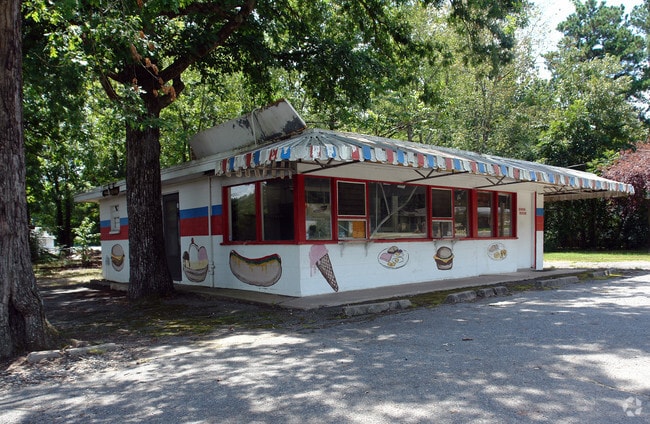
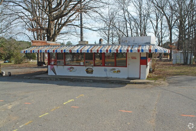
This Property Is For Sale
NEARBY LISTINGS FOR SALE OR LEASE
Property Detail
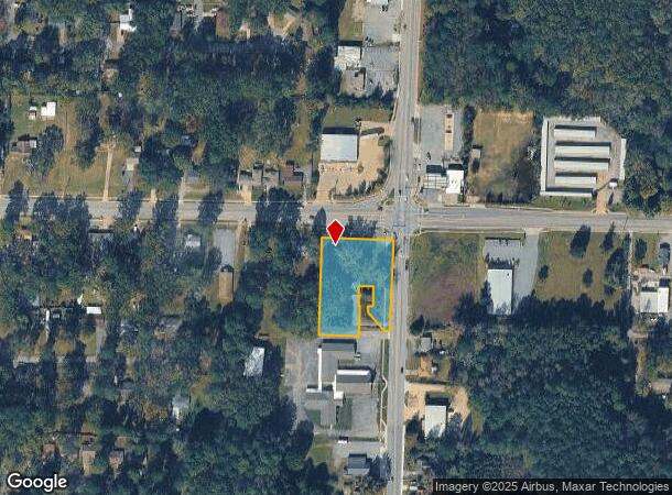
7615 Mabelvale Cut Off Rd
45L-061-00-010-01
Mabelvale
Restaurantbuilding
PT N330 OF E225 NE NE COM NE COR NE NE TH S2*3731W330 TO SE COR N330 NE NE TH N88*2351W39.7 TO W R/W CHICOT RD FOR POB TH CONT N88*2351W215.3 N2*3731E288.38 TO S R/W MABELVALE CUTOFF TH S85*5719E81.92 S88*2019E114.48 S43*2027E19.96
X
Pulaski
05119C0463G
Arkansas
2025
1.20 AC
2025
Outlying Pulaski County
004105
Little Rock/N Little Rock
980 SF
Little Rock-North Little Rock-Conway, AR
DEMOGRAPHICS near 7615 Mabelvale Cut Off Rd
1 Mile
3 Mile
5 Mile
2024 Total Population
9,513
35,379
77,430
2029 Population
9,486
35,587
78,490
Pop Growth 2024-2029
(0.28%)
+ 0.59%
+ 1.37%
Average Age
34
35
36
2024 Total Households
3,380
13,158
30,044
HH Growth 2024-2029
(0.30%)
+ 0.52%
+ 1.42%
Median Household Inc
$48,184
$42,580
$44,976
Avg Household Size
2.70
2.60
2.50
2024 Avg HH Vehicles
2.00
2.00
2.00
Median Home Value
$120,864
$105,908
$126,298
Median Year Built
1975
1974
1979
Nearby Places
Map Layers
Map Styles
 Street
 Aerial
- Restaurants
- Banks
- Shops
- Fitness
- Groceries
PUBLIC TRANSPORTATION
AIRPORT
Bill and Hillary Clinton Ntl/Adams Field
DRIVE
WALK
Distance
Bill and Hillary Clinton Ntl/Adams Field
16 min
11.5 mi
Freight Ports
Port of Shreveport
DRIVE
WALK
Distance
Port of Shreveport
242 min
225.9 mi
Nearby Properties
Address
Land Use
TOTAL SIZE
Lot Size
Zoning
Address
Land Use
TOTAL SIZE
Lot Size
Zoning
189,729 SF
57.75 AC
Address
Land Use
TOTAL SIZE
Lot Size
Zoning
10 SF
29.02 AC
Address
Land Use
TOTAL SIZE
Lot Size
Zoning
177,413 SF
35.78 AC
Address
Land Use
TOTAL SIZE
Lot Size
Zoning
185,805 SF
8.29 AC
Address
Land Use
TOTAL SIZE
Lot Size
Zoning
317,302 SF
44.38 AC
Address
Land Use
TOTAL SIZE
Lot Size
Zoning
79,751 SF
28.57 AC
Address
Land Use
TOTAL SIZE
Lot Size
Zoning
239,345 SF
19.70 AC
Address
Land Use
TOTAL SIZE
Lot Size
Zoning
365,104 SF
29.75 AC
Address
Land Use
TOTAL SIZE
Lot Size
Zoning
104,359 SF
14.63 AC
Address
Land Use
TOTAL SIZE
Lot Size
Zoning
34,925 SF
12.59 AC
Address
Land Use
TOTAL SIZE
Lot Size
Zoning
41,652 SF
10.86 AC
Address
Land Use
TOTAL SIZE
Lot Size
Zoning
7,937 SF
5.50 AC
Address
Land Use
TOTAL SIZE
Lot Size
Zoning
201,499 SF
21.70 AC
Address
Land Use
TOTAL SIZE
Lot Size
Zoning
131,278 SF
6.37 AC
Address
Land Use
TOTAL SIZE
Lot Size
Zoning
139,410 SF
8.35 AC
Address
Land Use
TOTAL SIZE
Lot Size
Zoning
24,520 SF
10.92 AC
Address
Land Use
TOTAL SIZE
Lot Size
Zoning
45,600 SF
6.45 AC
Address
Land Use
TOTAL SIZE
Lot Size
Zoning
30,356 SF
5.42 AC
Address
Land Use
TOTAL SIZE
Lot Size
Zoning
64,182 SF
17.80 AC
Address
Land Use
TOTAL SIZE
Lot Size
Zoning
33,216 SF
12.59 AC
Address
Land Use
TOTAL SIZE
Lot Size
Zoning
11,762 SF
9.05 AC
Address
Land Use
TOTAL SIZE
Lot Size
Zoning
309,271 SF
41.75 AC
Address
Land Use
TOTAL SIZE
Lot Size
Zoning
85,458 SF
9.86 AC
Address
Land Use
TOTAL SIZE
Lot Size
Zoning
7,482 SF
6.58 AC
Address
Land Use
TOTAL SIZE
Lot Size
Zoning
81,021 SF
10.28 AC
Address
Land Use
TOTAL SIZE
Lot Size
Zoning
19,440 SF
23.16 AC
Address
Land Use
TOTAL SIZE
Lot Size
Zoning
62,326 SF
5.84 AC
Address
Land Use
TOTAL SIZE
Lot Size
Zoning
16,200 SF
6.90 AC
Address
Land Use
TOTAL SIZE
Lot Size
Zoning
6,282 SF
61.51 AC
Address
Land Use
TOTAL SIZE
Lot Size
Zoning
16,032 SF
11.71 AC
The World's #1 Commercial Real Estate Marketplace
Connect with us
© 2025 CoStar Group
The information above has been obtained from sources believed reliable. While we do not doubt its accuracy we have not verified it and make no guarantee, warranty or representation about it. It is your responsibility to independently confirm its accuracy and completeness. Any projections, opinions, assumptions, or estimates used are for example only and do not represent the current or future performance of the property. The value of this transaction to you depends on tax and other factors which should be evaluated by your tax, financial, and legal advisors. You and your advisors should conduct a careful, independent investigation of the property to determine to your satisfaction the suitability of the property for your needs.