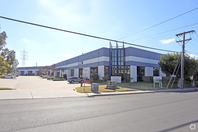
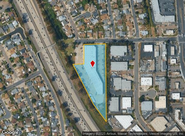
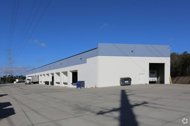
Property Record
7615 Othello Ave, San Diego, CA 92111
Current Lease Availabilities
NEARBY LISTINGS FOR SALE OR LEASE
Property Detail
7615 Othello Ave
356-350-49
Parcel Map No 10772
Warehouse
PAR 1 ST CLSD& TR PM10772
X
San Diego
06073C1608G
California
2024
3.97 AC
2025
Kearny Mesa
008511
San Diego
58,582 SF
San Diego-Carlsbad, CA
DEMOGRAPHICS near 7615 Othello Ave
1 Mile
3 Mile
5 Mile
2024 Total Population
15,878
131,235
356,670
2029 Population
15,758
130,905
356,828
Pop Growth 2024-2029
(0.76%)
(0.25%)
+ 0.04%
Average Age
39
38
39
2024 Total Households
6,262
51,088
155,523
HH Growth 2024-2029
(0.91%)
(0.25%)
+ 0.01%
Median Household Inc
$74,619
$94,673
$93,805
Avg Household Size
2.40
2.50
2.20
2024 Avg HH Vehicles
2.00
2.00
2.00
Median Home Value
$727,323
$749,851
$789,932
Median Year Built
1970
1974
1975
Nearby Places
Map Layers
Map Styles
 Street
 Aerial
- Restaurants
- Banks
- Shops
- Fitness
- Groceries
PUBLIC TRANSPORTATION
COMMUTER RAIL
Old Town Transit Center (Coaster - San Diego North County Transit District (Coaster/Sprinter/Breeze))
DRIVE
WALK
Distance
Old Town Transit Center (Coaster - San Diego North County Transit District (Coaster/Sprinter/Breeze))
13 min
7.1 mi
San Diego (Santa Fe Depot) (Coaster - San Diego North County Transit District (Coaster/Sprinter/Breeze))
DRIVE
WALK
Distance
San Diego (Santa Fe Depot) (Coaster - San Diego North County Transit District (Coaster/Sprinter/Breeze))
14 min
8.5 mi
AIRPORT
San Diego International
DRIVE
WALK
Distance
San Diego International
15 min
7.8 mi
Freight Ports
Port of San Diego
DRIVE
WALK
Distance
Port of San Diego
17 min
10.0 mi
Nearby Properties
Address
Land Use
TOTAL SIZE
Lot Size
Zoning
Address
Land Use
TOTAL SIZE
Lot Size
Zoning
19.04 AC
IL-2-1
Address
Land Use
TOTAL SIZE
Lot Size
Zoning
189,644 SF
20.49 AC
CO-1-2
Address
Land Use
TOTAL SIZE
Lot Size
Zoning
17.88 AC
CO-1-2
Address
Land Use
TOTAL SIZE
Lot Size
Zoning
46.03 AC
IH-2-1
Address
Land Use
TOTAL SIZE
Lot Size
Zoning
5.93 AC
CC-1-3
Address
Land Use
TOTAL SIZE
Lot Size
Zoning
5.09 AC
CC-3-8
Address
Land Use
TOTAL SIZE
Lot Size
Zoning
18.10 AC
RM-2-5
Address
Land Use
TOTAL SIZE
Lot Size
Zoning
7.48 AC
RM-3-9
Address
Land Use
TOTAL SIZE
Lot Size
Zoning
13.45 AC
IL-2-1
Address
Land Use
TOTAL SIZE
Lot Size
Zoning
13.04 AC
RM-2-5
Address
Land Use
TOTAL SIZE
Lot Size
Zoning
5.39 AC
CO-1-2
Address
Land Use
TOTAL SIZE
Lot Size
Zoning
7.50 AC
IL-2-1
Address
Land Use
TOTAL SIZE
Lot Size
Zoning
94,500 SF
9.96 AC
IL-3-1
Address
Land Use
TOTAL SIZE
Lot Size
Zoning
11.78 AC
CC-1-3
Address
Land Use
TOTAL SIZE
Lot Size
Zoning
5.87 AC
IL-2-1
Address
Land Use
TOTAL SIZE
Lot Size
Zoning
3.36 AC
RM-4-10
Address
Land Use
TOTAL SIZE
Lot Size
Zoning
14,940 SF
3.24 AC
CO-1-2
Address
Land Use
TOTAL SIZE
Lot Size
Zoning
19.67 AC
RM-2-5
Address
Land Use
TOTAL SIZE
Lot Size
Zoning
2.63 AC
CC-3-8
Address
Land Use
TOTAL SIZE
Lot Size
Zoning
3.46 AC
CC-3-8
Address
Land Use
TOTAL SIZE
Lot Size
Zoning
2.46 AC
CC-3-5
Address
Land Use
TOTAL SIZE
Lot Size
Zoning
15.40 AC
MVPD-MV-M
Address
Land Use
TOTAL SIZE
Lot Size
Zoning
10.20 AC
CC-3-5
Address
Land Use
TOTAL SIZE
Lot Size
Zoning
14.66 AC
IL-2-1
Address
Land Use
TOTAL SIZE
Lot Size
Zoning
14.66 AC
IL-2-1
Address
Land Use
TOTAL SIZE
Lot Size
Zoning
6.24 AC
IP-2-1
Address
Land Use
TOTAL SIZE
Lot Size
Zoning
5.11 AC
RM-3-9
Address
Land Use
TOTAL SIZE
Lot Size
Zoning
4.15 AC
MVPD-MV-CO
Address
Land Use
TOTAL SIZE
Lot Size
Zoning
17.07 AC
IL-2-1
Address
Land Use
TOTAL SIZE
Lot Size
Zoning
7.31 AC
RM-2-5
The World's #1 Commercial Real Estate Marketplace
Connect with us
© 2025 CoStar Group
The information above has been obtained from sources believed reliable. While we do not doubt its accuracy we have not verified it and make no guarantee, warranty or representation about it. It is your responsibility to independently confirm its accuracy and completeness. Any projections, opinions, assumptions, or estimates used are for example only and do not represent the current or future performance of the property. The value of this transaction to you depends on tax and other factors which should be evaluated by your tax, financial, and legal advisors. You and your advisors should conduct a careful, independent investigation of the property to determine to your satisfaction the suitability of the property for your needs.