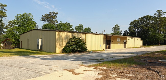
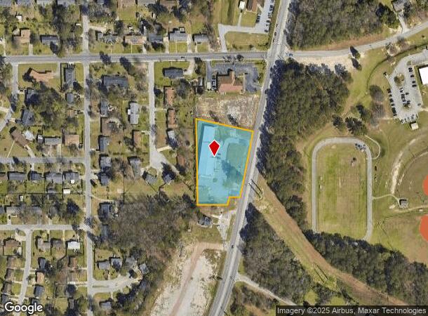
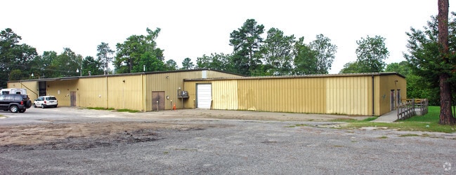
Property Record
7615 Wilson Blvd, Columbia, SC 29203

NEARBY LISTINGS FOR SALE OR LEASE
Property Detail
7615 Wilson Blvd
14304-05-15
435X35X38X35X37X190X ETC #SU #PR
Commercialnec
Richland
X
South Carolina
45079C0253L
1.85 AC
2024
North Columbia
2023
Columbia
010702
Columbia, SC
14,250 SF
DEMOGRAPHICS near 7615 Wilson Blvd
1 Mile
3 Mile
5 Mile
2024 Total Population
3,126
34,836
108,628
2029 Population
3,160
35,462
110,800
Pop Growth 2024-2029
+ 1.09%
+ 1.80%
+ 2.00%
Average Age
45
40
39
2024 Total Households
1,292
14,984
46,549
HH Growth 2024-2029
+ 1.16%
+ 1.87%
+ 2.08%
Median Household Inc
$33,543
$37,332
$43,860
Avg Household Size
2.30
2.20
2.20
2024 Avg HH Vehicles
2.00
2.00
2.00
Median Home Value
$133,582
$132,729
$171,552
Median Year Built
1970
1972
1973
Nearby Places
Map Layers
Map Styles
 Street
 Aerial
- Restaurants
- Banks
- Shops
- Fitness
- Groceries
PUBLIC TRANSPORTATION
COMMUTER RAIL
DRIVE
WALK
Distance
16 min
7.7 mi
AIRPORT
Columbia Metro
DRIVE
WALK
Distance
Columbia Metro
32 min
18.1 mi
SALE & LEASE HISTORY
LISTING DATE
SALE/LEASE

Sep 24, 2016
For Sale
Nearby Properties
Address
Land Use
TOTAL SIZE
Lot Size
Zoning
Address
Land Use
TOTAL SIZE
Lot Size
Zoning
144,849 SF
26.14 AC
OI
Address
Land Use
TOTAL SIZE
Lot Size
Zoning
456,536 SF
42.16 AC
M-1
Address
Land Use
TOTAL SIZE
Lot Size
Zoning
354,813 SF
20.66 AC
RM-HD
Address
Land Use
TOTAL SIZE
Lot Size
Zoning
172,390 SF
19.87 AC
GC
Address
Land Use
TOTAL SIZE
Lot Size
Zoning
234,990 SF
16.50 AC
RM-HD
Address
Land Use
TOTAL SIZE
Lot Size
Zoning
313,244 SF
12.75 AC
RM-HD
Address
Land Use
TOTAL SIZE
Lot Size
Zoning
260,572 SF
15 AC
GC
Address
Land Use
TOTAL SIZE
Lot Size
Zoning
200,609 SF
17.97 AC
GC
Address
Land Use
TOTAL SIZE
Lot Size
Zoning
239,450 SF
16.85 AC
GC
Address
Land Use
TOTAL SIZE
Lot Size
Zoning
183,237 SF
13.65 AC
GC
Address
Land Use
TOTAL SIZE
Lot Size
Zoning
147,062 SF
13.20 AC
GC
Address
Land Use
TOTAL SIZE
Lot Size
Zoning
242,894 SF
14.97 AC
RM-HD
Address
Land Use
TOTAL SIZE
Lot Size
Zoning
2,456 SF
5 AC
C-1
Address
Land Use
TOTAL SIZE
Lot Size
Zoning
23,379 SF
3.76 AC
M-1
Address
Land Use
TOTAL SIZE
Lot Size
Zoning
138,552 SF
12.02 AC
RM-HD
Address
Land Use
TOTAL SIZE
Lot Size
Zoning
223,692 SF
12 AC
GC
Address
Land Use
TOTAL SIZE
Lot Size
Zoning
156,185 SF
12.68 AC
GC
Address
Land Use
TOTAL SIZE
Lot Size
Zoning
46,032 SF
11.11 AC
RM-HD
Address
Land Use
TOTAL SIZE
Lot Size
Zoning
51,353 SF
7.01 AC
GC
Address
Land Use
TOTAL SIZE
Lot Size
Zoning
111,327 SF
7.96 AC
RM-HD
Address
Land Use
TOTAL SIZE
Lot Size
Zoning
72,938 SF
3.22 AC
M-1
Address
Land Use
TOTAL SIZE
Lot Size
Zoning
132,097 SF
10.63 AC
GC
Address
Land Use
TOTAL SIZE
Lot Size
Zoning
133,348 SF
18 AC
M-1
Address
Land Use
TOTAL SIZE
Lot Size
Zoning
80,000 SF
4.77 AC
M-1
Address
Land Use
TOTAL SIZE
Lot Size
Zoning
1,199.74 AC
OI
Address
Land Use
TOTAL SIZE
Lot Size
Zoning
124,272 SF
7.06 AC
RM-HD
Address
Land Use
TOTAL SIZE
Lot Size
Zoning
84,909 SF
8.26 AC
GC
Address
Land Use
TOTAL SIZE
Lot Size
Zoning
63,842 SF
3.52 AC
C-3
Address
Land Use
TOTAL SIZE
Lot Size
Zoning
183,184 SF
10.63 AC
GC
Address
Land Use
TOTAL SIZE
Lot Size
Zoning
123,647 SF
16.05 AC
GC
The World's #1 Commercial Real Estate Marketplace
Connect with us
© 2026 CoStar Group
The information above has been obtained from sources believed reliable. While we do not doubt its accuracy we have not verified it and make no guarantee, warranty or representation about it. It is your responsibility to independently confirm its accuracy and completeness. Any projections, opinions, assumptions, or estimates used are for example only and do not represent the current or future performance of the property. The value of this transaction to you depends on tax and other factors which should be evaluated by your tax, financial, and legal advisors. You and your advisors should conduct a careful, independent investigation of the property to determine to your satisfaction the suitability of the property for your needs.