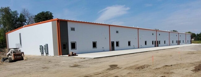
Property Record
7616 180Th St E, Prior Lake, MN 55372


Current Lease Availabilities
Property Detail
7616 180Th St E
4-908-010-1
SECTION 08 TOWNSHIP 114 RANGE 021 W 566' OF S1/2 SE1/4
Manufacturinglight
Scott
UER
Minnesota
B and X Area of moderate flood hazard, usually the area between the limits of the 100-year and 500-year floods.
17 AC
2025
Southwest
2025
Minneapolis/St Paul
081002
Minneapolis-St. Paul-Bloomington, MN-WI
2,132 SF
NEARBY LISTINGS FOR SALE OR LEASE
-
-
View all Prior Lake listings for lease on LoopNet.com
DEMOGRAPHICS near 7616 180Th St E
1 mile
3 mile
5 mile
2025 Total Population
488
13,643
82,887
2030 Population
504
14,020
85,044
Pop Growth 2025-2030
+ 3.28%
+ 2.76%
+ 2.60%
Average Age
42
40
40
2025 Total Households
159
4,810
29,987
HH Growth 2025-2030
+ 3.14%
+ 2.81%
+ 2.71%
Median Household Inc
$155,000
$126,464
$113,526
Avg Household Size
3.00
2.80
2.70
2025 Avg HH Vehicles
2.00
2.00
2.00
Median Home Value
$677,500
$515,609
$456,420
Median Year Built
1992
1997
1994
Nearby Places
Map Layers
Map Styles
 Street
 Aerial
Layers
 Traffic
 Biking
Places
Listings with unknown addresses are not visible on the map
- Restaurants
- Banks
- Shops
- Fitness
- Groceries
PUBLIC TRANSPORTATION
AIRPORT
Minneapolis-St Paul International/Wold-Chamberlain
Drive
Walk
Distance
Minneapolis-St Paul International/Wold-Chamberlain
31 min
22.2 mi
Freight Ports
Port Milwaukee
Drive
Walk
Distance
Port Milwaukee
392 min
354.4 mi
Nearby Properties
Address
Land Use
TOTAL SIZE
Lot Size
Zoning
Address
Land Use
TOTAL SIZE
Lot Size
Zoning
454,738 SF
106.74 AC
Address
Land Use
TOTAL SIZE
Lot Size
Zoning
323,174 SF
54.99 AC
Address
Land Use
TOTAL SIZE
Lot Size
Zoning
225,368 SF
34.46 AC
Address
Land Use
TOTAL SIZE
Lot Size
Zoning
48,508 SF
3.58 AC
Address
Land Use
TOTAL SIZE
Lot Size
Zoning
97,096 SF
15.34 AC
Address
Land Use
TOTAL SIZE
Lot Size
Zoning
89,306 SF
25.06 AC
Address
Land Use
TOTAL SIZE
Lot Size
Zoning
83,558 SF
8.44 AC
Address
Land Use
TOTAL SIZE
Lot Size
Zoning
83,120 SF
0.90 AC
Address
Land Use
TOTAL SIZE
Lot Size
Zoning
78,438 SF
8.73 AC
Address
Land Use
TOTAL SIZE
Lot Size
Zoning
71,922 SF
12.20 AC
Address
Land Use
TOTAL SIZE
Lot Size
Zoning
58,650 SF
7.07 AC
Address
Land Use
TOTAL SIZE
Lot Size
Zoning
33,110 SF
2.70 AC
Address
Land Use
TOTAL SIZE
Lot Size
Zoning
36,604 SF
3.78 AC
Address
Land Use
TOTAL SIZE
Lot Size
Zoning
49,128 SF
3.47 AC
Address
Land Use
TOTAL SIZE
Lot Size
Zoning
17,447 SF
6.39 AC
Address
Land Use
TOTAL SIZE
Lot Size
Zoning
10,297 SF
258.56 AC
RR-2
Address
Land Use
TOTAL SIZE
Lot Size
Zoning
31,313 SF
2.53 AC
Address
Land Use
TOTAL SIZE
Lot Size
Zoning
12.40 AC
Address
Land Use
TOTAL SIZE
Lot Size
Zoning
39,819 SF
7.05 AC
Address
Land Use
TOTAL SIZE
Lot Size
Zoning
Address
Land Use
TOTAL SIZE
Lot Size
Zoning
59,808 SF
12.68 AC
I-1
Address
Land Use
TOTAL SIZE
Lot Size
Zoning
17,984 SF
2.04 AC
Address
Land Use
TOTAL SIZE
Lot Size
Zoning
33,640 SF
2.90 AC
Address
Land Use
TOTAL SIZE
Lot Size
Zoning
29,420 SF
2.13 AC
Address
Land Use
TOTAL SIZE
Lot Size
Zoning
41,100 SF
3.11 AC
Address
Land Use
TOTAL SIZE
Lot Size
Zoning
27,686 SF
19.04 AC
UER
Address
Land Use
TOTAL SIZE
Lot Size
Zoning
64,082 SF
15.54 AC
Address
Land Use
TOTAL SIZE
Lot Size
Zoning
25,520 SF
1.81 AC
Address
Land Use
TOTAL SIZE
Lot Size
Zoning
25,158 SF
7.97 AC
Address
Land Use
TOTAL SIZE
Lot Size
Zoning
20,050 SF
8.95 AC
The World's #1 Commercial Real Estate Marketplace
Connect with us
© 2026 CoStar Group
The information above has been obtained from sources believed reliable. While we do not doubt its accuracy we have not verified it and make no guarantee, warranty or representation about it. It is your responsibility to independently confirm its accuracy and completeness. Any projections, opinions, assumptions, or estimates used are for example only and do not represent the current or future performance of the property. The value of this transaction to you depends on tax and other factors which should be evaluated by your tax, financial, and legal advisors. You and your advisors should conduct a careful, independent investigation of the property to determine to your satisfaction the suitability of the property for your needs.