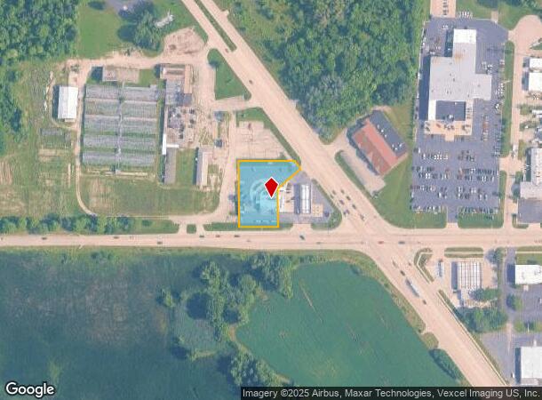
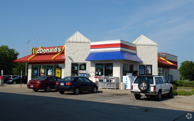
Property Record
7617 Rt 14, Crystal Lake, IL 60012

NEARBY LISTINGS FOR SALE OR LEASE
Property Detail
7617 Rt 14
14-31-177-016
DOC 2004R0012936 PT W HWY & N RD SE COR NW1/4 /EX PTOUT FOR RD PER CIR CT 12ED55/ MEMO: MIDWEST PETROLEUM DEVELOPMENT CO CRYSTAL LAKE INC
Commercialnec
McHenry
X
Illinois
17111C0326J
0.68 AC
2024
Far Northwest
2024
Chicago
870813
Chicago-Naperville-Elgin, IL-IN-WI
DEMOGRAPHICS near 7617 Rt 14
1 Mile
3 Mile
5 Mile
2024 Total Population
3,447
39,395
91,212
2029 Population
3,432
39,357
91,505
Pop Growth 2024-2029
(0.44%)
(0.10%)
+ 0.32%
Average Age
41
41
40
2024 Total Households
1,288
14,326
32,573
HH Growth 2024-2029
(0.39%)
(0.13%)
+ 0.36%
Median Household Inc
$98,105
$99,752
$99,157
Avg Household Size
2.60
2.70
2.70
2024 Avg HH Vehicles
2.00
2.00
2.00
Median Home Value
$262,056
$271,483
$268,710
Median Year Built
1968
1977
1991
Nearby Places
Map Layers
Map Styles
 Street
 Aerial
- Restaurants
- Banks
- Shops
- Fitness
- Groceries
PUBLIC TRANSPORTATION
COMMUTER RAIL
Crystal Lake Station (Union Pacific Northwest Line - Northeast Illinois Regional Commuter Railroad (Metra))
DRIVE
WALK
Distance
Crystal Lake Station (Union Pacific Northwest Line - Northeast Illinois Regional Commuter Railroad (Metra))
4 min
1.7 mi
Pingree Road Station (Union Pacific Northwest Line - Northeast Illinois Regional Commuter Railroad (Metra))
DRIVE
WALK
Distance
Pingree Road Station (Union Pacific Northwest Line - Northeast Illinois Regional Commuter Railroad (Metra))
9 min
4.2 mi
AIRPORT
Chicago O'Hare International
DRIVE
WALK
Distance
Chicago O'Hare International
54 min
36.3 mi
Nearby Properties
Address
Land Use
TOTAL SIZE
Lot Size
Zoning
Address
Land Use
TOTAL SIZE
Lot Size
Zoning
15.94 AC
Address
Land Use
TOTAL SIZE
Lot Size
Zoning
Address
Land Use
TOTAL SIZE
Lot Size
Zoning
64,269 SF
5.08 AC
Address
Land Use
TOTAL SIZE
Lot Size
Zoning
Address
Land Use
TOTAL SIZE
Lot Size
Zoning
173,572 SF
17.03 AC
Address
Land Use
TOTAL SIZE
Lot Size
Zoning
71,703 SF
0.50 AC
Address
Land Use
TOTAL SIZE
Lot Size
Zoning
362,936 SF
6.08 AC
Address
Land Use
TOTAL SIZE
Lot Size
Zoning
125,187 SF
10.59 AC
Address
Land Use
TOTAL SIZE
Lot Size
Zoning
86,400 SF
5.87 AC
Address
Land Use
TOTAL SIZE
Lot Size
Zoning
66,594 SF
5.22 AC
Address
Land Use
TOTAL SIZE
Lot Size
Zoning
51,909 SF
0.50 AC
Address
Land Use
TOTAL SIZE
Lot Size
Zoning
34,448 SF
2 AC
Address
Land Use
TOTAL SIZE
Lot Size
Zoning
Address
Land Use
TOTAL SIZE
Lot Size
Zoning
127,059 SF
16.84 AC
Address
Land Use
TOTAL SIZE
Lot Size
Zoning
122,668 SF
9.73 AC
Address
Land Use
TOTAL SIZE
Lot Size
Zoning
10.48 AC
Address
Land Use
TOTAL SIZE
Lot Size
Zoning
141,363 SF
9 AC
Address
Land Use
TOTAL SIZE
Lot Size
Zoning
Address
Land Use
TOTAL SIZE
Lot Size
Zoning
76,680 SF
0.70 AC
Address
Land Use
TOTAL SIZE
Lot Size
Zoning
89,660 SF
9.86 AC
Address
Land Use
TOTAL SIZE
Lot Size
Zoning
79,462 SF
0.80 AC
Address
Land Use
TOTAL SIZE
Lot Size
Zoning
56,537 SF
4.80 AC
Address
Land Use
TOTAL SIZE
Lot Size
Zoning
35,062 SF
13 AC
Address
Land Use
TOTAL SIZE
Lot Size
Zoning
118,400 SF
8 AC
Address
Land Use
TOTAL SIZE
Lot Size
Zoning
80,362 SF
6.13 AC
Address
Land Use
TOTAL SIZE
Lot Size
Zoning
25,932 SF
6.43 AC
Address
Land Use
TOTAL SIZE
Lot Size
Zoning
115,753 SF
7 AC
Address
Land Use
TOTAL SIZE
Lot Size
Zoning
197,155 SF
3.70 AC
Address
Land Use
TOTAL SIZE
Lot Size
Zoning
129,474 SF
4.24 AC
Address
Land Use
TOTAL SIZE
Lot Size
Zoning
30,180 SF
4.63 AC
The World's #1 Commercial Real Estate Marketplace
Connect with us
© 2025 CoStar Group
The information above has been obtained from sources believed reliable. While we do not doubt its accuracy we have not verified it and make no guarantee, warranty or representation about it. It is your responsibility to independently confirm its accuracy and completeness. Any projections, opinions, assumptions, or estimates used are for example only and do not represent the current or future performance of the property. The value of this transaction to you depends on tax and other factors which should be evaluated by your tax, financial, and legal advisors. You and your advisors should conduct a careful, independent investigation of the property to determine to your satisfaction the suitability of the property for your needs.