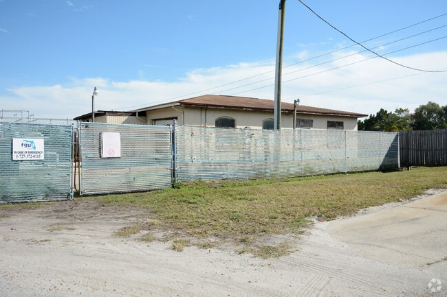
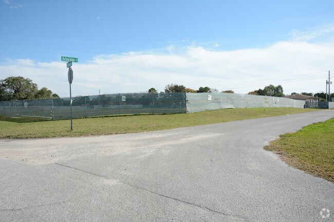
Property Record
7618 Arbordale Dr, Port Richey, FL 34668
NEARBY LISTINGS FOR SALE OR LEASE
-
-
View all Port Richey listings for sale on LoopNet.com
Property Detail
7618 Arbordale Dr
Tampa-St. Petersburg-Clearwater, FL
Palm Terrace Gardens Unrecorded
10-25-16-053A-00000-00B0
PALM TERRACE GARDENS UNIT 3 RECORDED IN OR 640 PGS 324 & 325 LOT 596 OR 8851 PG 2675
Countyproperty
Pasco
X
Florida
12101C0179G
596
0
1.73 AC
2025
Pasco County
031010
Tampa/St Petersburg
1,225 SF
DEMOGRAPHICS near 7618 Arbordale Dr
1 Mile
3 Mile
5 Mile
2024 Total Population
17,456
71,905
127,006
2029 Population
20,860
86,245
152,401
Pop Growth 2024-2029
+ 19.50%
+ 19.94%
+ 20.00%
Average Age
45
45
46
2024 Total Households
7,657
31,019
55,568
HH Growth 2024-2029
+ 19.60%
+ 19.97%
+ 20.01%
Median Household Inc
$40,265
$43,521
$45,741
Avg Household Size
2.30
2.30
2.20
2024 Avg HH Vehicles
1.00
2.00
2.00
Median Home Value
$109,098
$143,819
$163,218
Median Year Built
1976
1978
1980
Nearby Places
Map Layers
Map Styles
 Street
 Aerial
- Restaurants
- Banks
- Shops
- Fitness
- Groceries
PUBLIC TRANSPORTATION
AIRPORT
St Pete-Clearwater International
DRIVE
WALK
Distance
St Pete-Clearwater International
61 min
35.5 mi
Tampa International
DRIVE
WALK
Distance
Tampa International
56 min
39.6 mi
Freight Ports
Port of Tampa Bay
DRIVE
WALK
Distance
Port of Tampa Bay
69 min
42.6 mi
Nearby Properties
Address
Land Use
TOTAL SIZE
Lot Size
Zoning
Address
Land Use
TOTAL SIZE
Lot Size
Zoning
395,386 SF
35.63 AC
C2
Address
Land Use
TOTAL SIZE
Lot Size
Zoning
250,601 SF
38.64 AC
C2
Address
Land Use
TOTAL SIZE
Lot Size
Zoning
218,736 SF
39.17 AC
R1
Address
Land Use
TOTAL SIZE
Lot Size
Zoning
351,012 SF
23.51 AC
MF2
Address
Land Use
TOTAL SIZE
Lot Size
Zoning
220,843 SF
35.13 AC
C2
Address
Land Use
TOTAL SIZE
Lot Size
Zoning
124,316 SF
22.91 AC
MF1
Address
Land Use
TOTAL SIZE
Lot Size
Zoning
122,037 SF
13.83 AC
MF1
Address
Land Use
TOTAL SIZE
Lot Size
Zoning
121,284 SF
10.25 AC
MF1
Address
Land Use
TOTAL SIZE
Lot Size
Zoning
220,045 SF
22.67 AC
C2
Address
Land Use
TOTAL SIZE
Lot Size
Zoning
124,470 SF
5.09 AC
C2
Address
Land Use
TOTAL SIZE
Lot Size
Zoning
183,139 SF
19.66 AC
C2
Address
Land Use
TOTAL SIZE
Lot Size
Zoning
217,350 SF
11.20 AC
PUD
Address
Land Use
TOTAL SIZE
Lot Size
Zoning
189,166 SF
18.19 AC
C2
Address
Land Use
TOTAL SIZE
Lot Size
Zoning
106,741 SF
27.67 AC
MF1
Address
Land Use
TOTAL SIZE
Lot Size
Zoning
217,758 SF
34.95 AC
C2
Address
Land Use
TOTAL SIZE
Lot Size
Zoning
220,024 SF
25.72 AC
C1
Address
Land Use
TOTAL SIZE
Lot Size
Zoning
190,794 SF
10.88 AC
C2
Address
Land Use
TOTAL SIZE
Lot Size
Zoning
86,570 SF
8.06 AC
MF1
Address
Land Use
TOTAL SIZE
Lot Size
Zoning
111,060 SF
9.31 AC
C3
Address
Land Use
TOTAL SIZE
Lot Size
Zoning
137,157 SF
18.59 AC
C2
Address
Land Use
TOTAL SIZE
Lot Size
Zoning
84,225 SF
5.21 AC
C2
Address
Land Use
TOTAL SIZE
Lot Size
Zoning
85,003 SF
25 AC
R4
Address
Land Use
TOTAL SIZE
Lot Size
Zoning
91,670 SF
3.51 AC
C2
Address
Land Use
TOTAL SIZE
Lot Size
Zoning
81,839 SF
3.33 AC
C2
Address
Land Use
TOTAL SIZE
Lot Size
Zoning
117,549 SF
8.07 AC
C2
Address
Land Use
TOTAL SIZE
Lot Size
Zoning
90,113 SF
8.22 AC
C2
Address
Land Use
TOTAL SIZE
Lot Size
Zoning
83,363 SF
5.97 AC
C2
Address
Land Use
TOTAL SIZE
Lot Size
Zoning
78,580 SF
21.43 AC
PUD
Address
Land Use
TOTAL SIZE
Lot Size
Zoning
38,187 SF
6.48 AC
MPUD
Address
Land Use
TOTAL SIZE
Lot Size
Zoning
48,048 SF
15.56 AC
MF2
The World's #1 Commercial Real Estate Marketplace
Connect with us
© 2025 CoStar Group
The information above has been obtained from sources believed reliable. While we do not doubt its accuracy we have not verified it and make no guarantee, warranty or representation about it. It is your responsibility to independently confirm its accuracy and completeness. Any projections, opinions, assumptions, or estimates used are for example only and do not represent the current or future performance of the property. The value of this transaction to you depends on tax and other factors which should be evaluated by your tax, financial, and legal advisors. You and your advisors should conduct a careful, independent investigation of the property to determine to your satisfaction the suitability of the property for your needs.