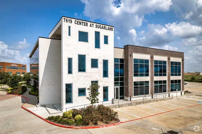
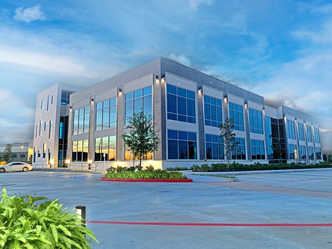
Property Record
7619 Branford Pl, Sugar Land, TX 77479

Current Lease Availabilities
NEARBY LISTINGS FOR SALE OR LEASE
Property Detail
7619 Branford Pl
Houston-The Woodlands-Sugar Land, TX
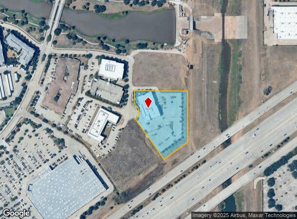
Telfair Lakefront District East Bus Park
8701-02-000-0020-907
TELFAIR LAKEFRONT DISTRICT EAST BUS PARK COMM RSVS PHASE 2, ACRES 3.123, RESTRICTED RESERVE B (COMMERCIAL), TELFAIR LAKEFRONT DISTRICT EAST BUS PARK COMM RSVS PHASE 1
Commercialnec
Fort Bend
X
Texas
48157C0260L
3.12 AC
2024
E Fort Bend Co/Sugar Land
2025
Houston
673902
DEMOGRAPHICS near 7619 Branford Pl
1 Mile
3 Mile
5 Mile
2024 Total Population
8,472
77,457
202,998
2029 Population
10,097
92,307
242,614
Pop Growth 2024-2029
+ 19.18%
+ 19.17%
+ 19.52%
Average Age
39
41
40
2024 Total Households
2,695
26,938
68,576
HH Growth 2024-2029
+ 19.85%
+ 19.86%
+ 20.14%
Median Household Inc
$153,371
$117,446
$107,198
Avg Household Size
3.10
2.80
2.90
2024 Avg HH Vehicles
2.00
2.00
2.00
Median Home Value
$470,786
$406,677
$358,299
Median Year Built
2003
1994
1996
Nearby Places
Map Layers
Map Styles
 Street
 Aerial
- Restaurants
- Banks
- Shops
- Fitness
- Groceries
PUBLIC TRANSPORTATION
AIRPORT
William P Hobby
DRIVE
WALK
Distance
William P Hobby
44 min
30.0 mi
Freight Ports
Port of Houston
DRIVE
WALK
Distance
Port of Houston
46 min
30.7 mi
Nearby Properties
Address
Land Use
TOTAL SIZE
Lot Size
Zoning
Address
Land Use
TOTAL SIZE
Lot Size
Zoning
189,381 SF
167.45 AC
Address
Land Use
TOTAL SIZE
Lot Size
Zoning
448,502 SF
35.66 AC
Address
Land Use
TOTAL SIZE
Lot Size
Zoning
171,425 SF
29.96 AC
Address
Land Use
TOTAL SIZE
Lot Size
Zoning
221,618 SF
6.50 AC
Address
Land Use
TOTAL SIZE
Lot Size
Zoning
198,085 SF
9.79 AC
Address
Land Use
TOTAL SIZE
Lot Size
Zoning
378,797 SF
10.97 AC
Address
Land Use
TOTAL SIZE
Lot Size
Zoning
Address
Land Use
TOTAL SIZE
Lot Size
Zoning
77,850 SF
8.53 AC
YQZ
Address
Land Use
TOTAL SIZE
Lot Size
Zoning
260,269 SF
8.53 AC
Address
Land Use
TOTAL SIZE
Lot Size
Zoning
Address
Land Use
TOTAL SIZE
Lot Size
Zoning
171,800 SF
11.92 AC
Address
Land Use
TOTAL SIZE
Lot Size
Zoning
129,813 SF
8.53 AC
Address
Land Use
TOTAL SIZE
Lot Size
Zoning
149,261 SF
12.15 AC
SJ
Address
Land Use
TOTAL SIZE
Lot Size
Zoning
203,739 SF
13.28 AC
Address
Land Use
TOTAL SIZE
Lot Size
Zoning
89,033 SF
12.46 AC
Address
Land Use
TOTAL SIZE
Lot Size
Zoning
254,210 SF
10.59 AC
JT
Address
Land Use
TOTAL SIZE
Lot Size
Zoning
102,715 SF
14.99 AC
Address
Land Use
TOTAL SIZE
Lot Size
Zoning
49,976 SF
0.79 AC
X
Address
Land Use
TOTAL SIZE
Lot Size
Zoning
310,144 SF
7.19 AC
Address
Land Use
TOTAL SIZE
Lot Size
Zoning
194,593 SF
2.29 AC
X
Address
Land Use
TOTAL SIZE
Lot Size
Zoning
190,152 SF
13.17 AC
I
Address
Land Use
TOTAL SIZE
Lot Size
Zoning
26.16 AC
Address
Land Use
TOTAL SIZE
Lot Size
Zoning
85,872 SF
12.65 AC
S
Address
Land Use
TOTAL SIZE
Lot Size
Zoning
172,513 SF
10.26 AC
Y
Address
Land Use
TOTAL SIZE
Lot Size
Zoning
699,266 SF
53.01 AC
Address
Land Use
TOTAL SIZE
Lot Size
Zoning
53,533 SF
10.98 AC
Address
Land Use
TOTAL SIZE
Lot Size
Zoning
412,620 SF
53.34 AC
Y
Address
Land Use
TOTAL SIZE
Lot Size
Zoning
153,036 SF
0.93 AC
Address
Land Use
TOTAL SIZE
Lot Size
Zoning
25,220 SF
30.79 AC
SYM
Address
Land Use
TOTAL SIZE
Lot Size
Zoning
279,112 SF
7.86 AC
Z
The World's #1 Commercial Real Estate Marketplace
Connect with us
© 2026 CoStar Group
The information above has been obtained from sources believed reliable. While we do not doubt its accuracy we have not verified it and make no guarantee, warranty or representation about it. It is your responsibility to independently confirm its accuracy and completeness. Any projections, opinions, assumptions, or estimates used are for example only and do not represent the current or future performance of the property. The value of this transaction to you depends on tax and other factors which should be evaluated by your tax, financial, and legal advisors. You and your advisors should conduct a careful, independent investigation of the property to determine to your satisfaction the suitability of the property for your needs.