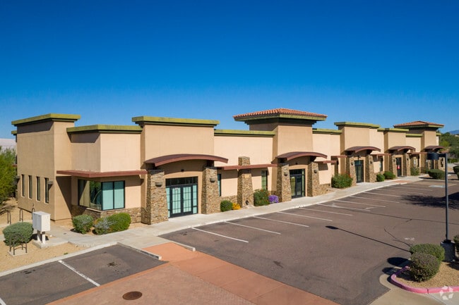
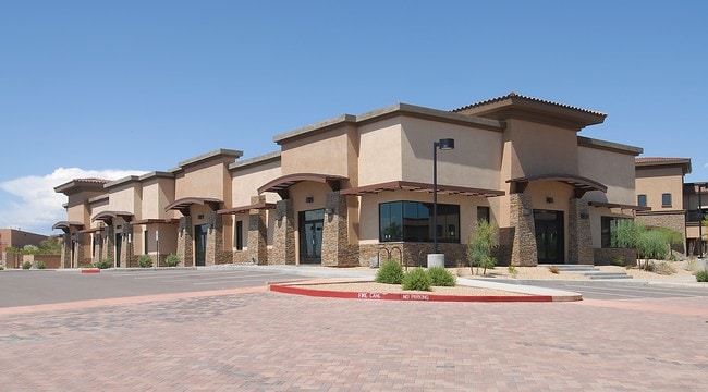
Property Record
7619 E Pinnacle Peak Rd, Scottsdale, AZ 85255

Current Lease Availabilities
Property Detail
7619 E Pinnacle Peak Rd
212-03-563
PEAKS CORPORATE PARK 2 CONDOMINIUM MCR 1002-18
Officecondo
Maricopa
C-T
Arizona
B and X Area of moderate flood hazard, usually the area between the limits of the 100-year and 500-year floods.
100
2025
0.06 AC
2025
N Scottsdale/Carefree
216841
Phoenix
12,680 SF
Phoenix-Mesa-Chandler, AZ
NEARBY LISTINGS FOR SALE OR LEASE
DEMOGRAPHICS near 7619 E Pinnacle Peak Rd
1 mile
3 mile
5 mile
2025 Total Population
7,307
30,207
105,744
2030 Population
7,663
32,280
112,296
Pop Growth 2025-2030
+ 4.87%
+ 6.86%
+ 6.20%
Average Age
47
48
45
2025 Total Households
3,036
13,622
46,261
HH Growth 2025-2030
+ 4.87%
+ 7.38%
+ 6.77%
Median Household Inc
$124,877
$134,582
$133,790
Avg Household Size
2.30
2.20
2.20
2025 Avg HH Vehicles
2.00
2.00
2.00
Median Home Value
$856,926
$1,001,941
$895,123
Median Year Built
1998
2001
2000
Nearby Places
Map Layers
Map Styles
 Street
 Aerial
Layers
 Traffic
 Biking
Places
Listings with unknown addresses are not visible on the map
- Restaurants
- Banks
- Shops
- Fitness
- Groceries
PUBLIC TRANSPORTATION
AIRPORT
Phoenix Sky Harbor International
Drive
Walk
Distance
Phoenix Sky Harbor International
38 min
26.4 mi
Phoenix-Mesa Gateway
Drive
Walk
Distance
Phoenix-Mesa Gateway
58 min
41.7 mi
Nearby Properties
Address
Land Use
TOTAL SIZE
Lot Size
Zoning
Address
Land Use
TOTAL SIZE
Lot Size
Zoning
20.98 AC
Address
Land Use
TOTAL SIZE
Lot Size
Zoning
14.58 AC
Address
Land Use
TOTAL SIZE
Lot Size
Zoning
1,479,005 SF
12.55 AC
PC
Address
Land Use
TOTAL SIZE
Lot Size
Zoning
Address
Land Use
TOTAL SIZE
Lot Size
Zoning
Address
Land Use
TOTAL SIZE
Lot Size
Zoning
229,856 SF
7.71 AC
C-T
Address
Land Use
TOTAL SIZE
Lot Size
Zoning
734,840 SF
33.12 AC
M-H
Address
Land Use
TOTAL SIZE
Lot Size
Zoning
90.73 AC
O-S
Address
Land Use
TOTAL SIZE
Lot Size
Zoning
255,313 SF
22.54 AC
PNC
Address
Land Use
TOTAL SIZE
Lot Size
Zoning
385,376 SF
13.65 AC
PAD
Address
Land Use
TOTAL SIZE
Lot Size
Zoning
702,652 SF
4.58 AC
Address
Land Use
TOTAL SIZE
Lot Size
Zoning
375,257 SF
12 AC
M-H
Address
Land Use
TOTAL SIZE
Lot Size
Zoning
41.63 AC
I-1
Address
Land Use
TOTAL SIZE
Lot Size
Zoning
731,843 SF
29.85 AC
M-H
Address
Land Use
TOTAL SIZE
Lot Size
Zoning
328,616 SF
10.56 AC
PAD
Address
Land Use
TOTAL SIZE
Lot Size
Zoning
397,568 SF
16.71 AC
PAD
Address
Land Use
TOTAL SIZE
Lot Size
Zoning
373,066 SF
13 AC
M-H
Address
Land Use
TOTAL SIZE
Lot Size
Zoning
58.66 AC
R-43AG
Address
Land Use
TOTAL SIZE
Lot Size
Zoning
161,955 SF
2.65 AC
Address
Land Use
TOTAL SIZE
Lot Size
Zoning
157,340 SF
4.40 AC
PC
Address
Land Use
TOTAL SIZE
Lot Size
Zoning
570.07 AC
R-43
Address
Land Use
TOTAL SIZE
Lot Size
Zoning
286,776 SF
5.86 AC
C-T
Address
Land Use
TOTAL SIZE
Lot Size
Zoning
48.10 AC
Address
Land Use
TOTAL SIZE
Lot Size
Zoning
201,308 SF
3.44 AC
PC
Address
Land Use
TOTAL SIZE
Lot Size
Zoning
66,317 SF
20.82 AC
R-190
Address
Land Use
TOTAL SIZE
Lot Size
Zoning
115,275 SF
12.16 AC
C-C
Address
Land Use
TOTAL SIZE
Lot Size
Zoning
100,378 SF
12.29 AC
C-C
Address
Land Use
TOTAL SIZE
Lot Size
Zoning
80,105 SF
12.35 AC
PAD
Address
Land Use
TOTAL SIZE
Lot Size
Zoning
311,819 SF
3.84 AC
R4
The World's #1 Commercial Real Estate Marketplace
Connect with us
© 2026 CoStar Group
The information above has been obtained from sources believed reliable. While we do not doubt its accuracy we have not verified it and make no guarantee, warranty or representation about it. It is your responsibility to independently confirm its accuracy and completeness. Any projections, opinions, assumptions, or estimates used are for example only and do not represent the current or future performance of the property. The value of this transaction to you depends on tax and other factors which should be evaluated by your tax, financial, and legal advisors. You and your advisors should conduct a careful, independent investigation of the property to determine to your satisfaction the suitability of the property for your needs.