Property Record
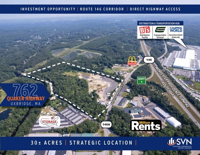
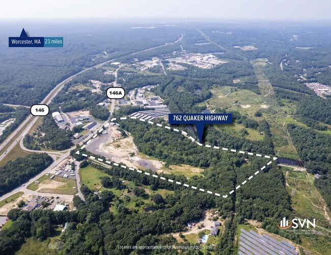
762 Quaker Hwy, Uxbridge, MA 01569
This Property Is For Sale
NEARBY LISTINGS FOR SALE OR LEASE
Property Detail
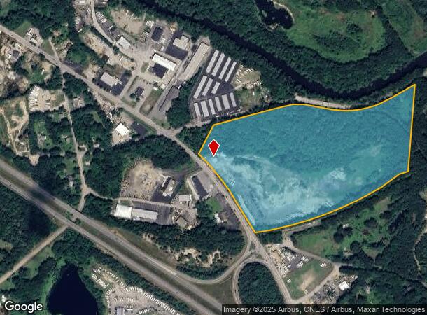
762 Quaker Hwy
Minequarry
Worcester
AE
Massachusetts
25021C0300E
30 AC
2025
Outlying Worcester
2025
Boston
749100
Worcester, MA-CT
1,753 SF
UXBR-000510-000126
DEMOGRAPHICS near 762 Quaker Hwy
1 Mile
3 Mile
5 Mile
2024 Total Population
796
12,987
51,541
2029 Population
802
13,001
51,282
Pop Growth 2024-2029
+ 0.75%
+ 0.11%
(0.50%)
Average Age
41
42
42
2024 Total Households
295
4,968
20,441
HH Growth 2024-2029
+ 0.68%
+ 0.04%
(0.61%)
Median Household Inc
$115,624
$109,772
$86,409
Avg Household Size
2.70
2.60
2.50
2024 Avg HH Vehicles
2.00
2.00
2.00
Median Home Value
$423,786
$405,198
$379,119
Median Year Built
1987
1981
1965
Nearby Places
- Restaurants
- Banks
- Shops
- Fitness
- Groceries
PUBLIC TRANSPORTATION
AIRPORT
Worcester Regional
DRIVE
WALK
Distance
Worcester Regional
36 min
25.9 mi
Rhode Island Tf Green International
DRIVE
WALK
Distance
Rhode Island Tf Green International
38 min
27.1 mi
Freight Ports
Port of Davisville, RI
DRIVE
WALK
Distance
Port of Davisville, RI
52 min
38.9 mi
Nearby Properties
Address
Land Use
TOTAL SIZE
Lot Size
Zoning
Address
Land Use
TOTAL SIZE
Lot Size
Zoning
602,336 SF
204.50 AC
B
Address
Land Use
TOTAL SIZE
Lot Size
Zoning
31.45 AC
M
Address
Land Use
TOTAL SIZE
Lot Size
Zoning
108.65 AC
RC
Address
Land Use
TOTAL SIZE
Lot Size
Zoning
48,071 SF
44.42 AC
I
Address
Land Use
TOTAL SIZE
Lot Size
Zoning
27,720 SF
4.36 AC
I
Address
Land Use
TOTAL SIZE
Lot Size
Zoning
65,809 SF
17.66 AC
BN
Address
Land Use
TOTAL SIZE
Lot Size
Zoning
28,468 SF
1.24 AC
I
Address
Land Use
TOTAL SIZE
Lot Size
Zoning
25,100 SF
7.40 AC
I
Address
Land Use
TOTAL SIZE
Lot Size
Zoning
42,837 SF
11.32 AC
RS
Address
Land Use
TOTAL SIZE
Lot Size
Zoning
18.32 AC
M
Address
Land Use
TOTAL SIZE
Lot Size
Zoning
52,041 SF
47.80 AC
VRD
Address
Land Use
TOTAL SIZE
Lot Size
Zoning
57,698 SF
8.36 AC
RS
Address
Land Use
TOTAL SIZE
Lot Size
Zoning
8,736 SF
35.28 AC
REA
Address
Land Use
TOTAL SIZE
Lot Size
Zoning
64,110 SF
6 AC
I
Address
Land Use
TOTAL SIZE
Lot Size
Zoning
9,464 SF
53.10 AC
AG
Address
Land Use
TOTAL SIZE
Lot Size
Zoning
85,632 SF
6.69 AC
M
Address
Land Use
TOTAL SIZE
Lot Size
Zoning
33,552 SF
7.87 AC
I
Address
Land Use
TOTAL SIZE
Lot Size
Zoning
53,875 SF
5.42 AC
C
Address
Land Use
TOTAL SIZE
Lot Size
Zoning
56.47 AC
RES
Address
Land Use
TOTAL SIZE
Lot Size
Zoning
2.51 AC
RA
Address
Land Use
TOTAL SIZE
Lot Size
Zoning
43,654 SF
5.29 AC
I
Address
Land Use
TOTAL SIZE
Lot Size
Zoning
72,634 SF
6.80 AC
M
Address
Land Use
TOTAL SIZE
Lot Size
Zoning
17,924 SF
5.62 AC
I
Address
Land Use
TOTAL SIZE
Lot Size
Zoning
2,706 SF
43.74 AC
RC
Address
Land Use
TOTAL SIZE
Lot Size
Zoning
54.64 AC
REA
Address
Land Use
TOTAL SIZE
Lot Size
Zoning
32,428 SF
5.99 AC
B
Address
Land Use
TOTAL SIZE
Lot Size
Zoning
27,673 SF
10.01 AC
B
Address
Land Use
TOTAL SIZE
Lot Size
Zoning
12,848 SF
2.62 AC
RS
Address
Land Use
TOTAL SIZE
Lot Size
Zoning
5,728 SF
11.73 AC
I
Address
Land Use
TOTAL SIZE
Lot Size
Zoning
21,993 SF
2.66 AC
B
The World's #1 Commercial Real Estate Marketplace
Connect with us
© 2025 CoStar Group
The information above has been obtained from sources believed reliable. While we do not doubt its accuracy we have not verified it and make no guarantee, warranty or representation about it. It is your responsibility to independently confirm its accuracy and completeness. Any projections, opinions, assumptions, or estimates used are for example only and do not represent the current or future performance of the property. The value of this transaction to you depends on tax and other factors which should be evaluated by your tax, financial, and legal advisors. You and your advisors should conduct a careful, independent investigation of the property to determine to your satisfaction the suitability of the property for your needs.