Property Record
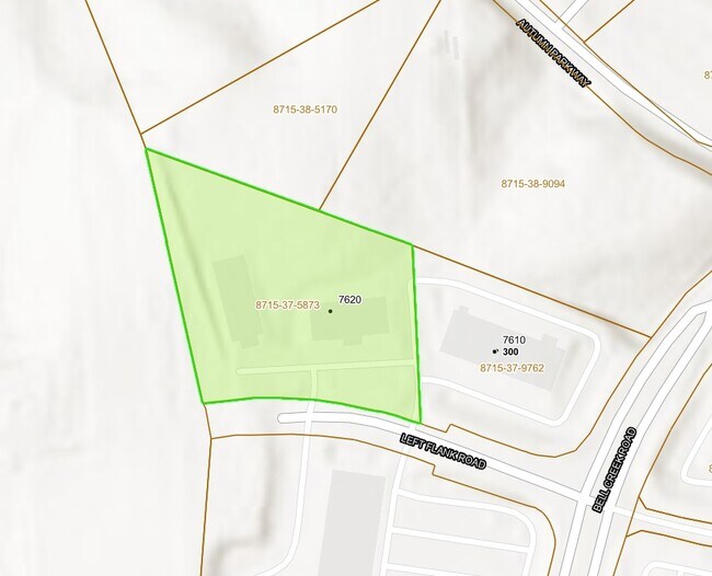
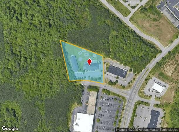
7620 Left Flank Rd, Mechanicsville, VA 23116
NEARBY LISTINGS FOR SALE OR LEASE
Property Detail
7620 Left Flank Rd
Richmond, VA
Bell Creek Park
8715-37-5873
BELL CREEK PARK LOT 1 BLK C
Commercialnec
Hanover
X
Virginia
51085C0340C
1
2025
2.88 AC
2025
I-95 Chamberlayne/NE
320902
Richmond VA
16,136 SF
DEMOGRAPHICS near 7620 Left Flank Rd
1 Mile
3 Mile
5 Mile
2024 Total Population
3,232
36,697
78,605
2029 Population
3,450
39,120
82,566
Pop Growth 2024-2029
+ 6.75%
+ 6.60%
+ 5.04%
Average Age
44
42
42
2024 Total Households
1,189
14,368
30,534
HH Growth 2024-2029
+ 6.98%
+ 6.72%
+ 4.99%
Median Household Inc
$104,187
$91,949
$89,556
Avg Household Size
2.60
2.50
2.50
2024 Avg HH Vehicles
2.00
2.00
2.00
Median Home Value
$334,823
$290,559
$290,295
Median Year Built
1999
1990
1988
Nearby Places
Map Layers
Map Styles
 Street
 Aerial
- Restaurants
- Banks
- Shops
- Fitness
- Groceries
PUBLIC TRANSPORTATION
COMMUTER RAIL
Richmond Staples Mill Road Amtrak Station (Carolinian - Amtrak, Northeast Regional - Amtrak, Palmetto - Amtrak, Silver Meteor - Amtrak)
DRIVE
WALK
Distance
Richmond Staples Mill Road Amtrak Station (Carolinian - Amtrak, Northeast Regional - Amtrak, Palmetto - Amtrak, Silver Meteor - Amtrak)
19 min
9.7 mi
AIRPORT
Richmond International
DRIVE
WALK
Distance
Richmond International
21 min
14.0 mi
Freight Ports
Virginia Port Authority - Richmond
DRIVE
WALK
Distance
Virginia Port Authority - Richmond
28 min
16.7 mi
Nearby Properties
Address
Land Use
TOTAL SIZE
Lot Size
Zoning
Address
Land Use
TOTAL SIZE
Lot Size
Zoning
436,148 SF
12.73 AC
B-1
Address
Land Use
TOTAL SIZE
Lot Size
Zoning
32,407 SF
1.18 AC
UMU
Address
Land Use
TOTAL SIZE
Lot Size
Zoning
1.37 AC
A-1
Address
Land Use
TOTAL SIZE
Lot Size
Zoning
23.50 AC
A-1
Address
Land Use
TOTAL SIZE
Lot Size
Zoning
14.41 AC
A-1
Address
Land Use
TOTAL SIZE
Lot Size
Zoning
2,630 SF
39.79 AC
M-2
Address
Land Use
TOTAL SIZE
Lot Size
Zoning
18.50 AC
RM
Address
Land Use
TOTAL SIZE
Lot Size
Zoning
16,413 SF
128.40 AC
A-1
Address
Land Use
TOTAL SIZE
Lot Size
Zoning
1,249,190 SF
139.90 AC
M-2
Address
Land Use
TOTAL SIZE
Lot Size
Zoning
23.49 AC
A-1
Address
Land Use
TOTAL SIZE
Lot Size
Zoning
29.95 AC
A-1
Address
Land Use
TOTAL SIZE
Lot Size
Zoning
2,145 SF
4.54 AC
B-1
Address
Land Use
TOTAL SIZE
Lot Size
Zoning
30 AC
A-1
Address
Land Use
TOTAL SIZE
Lot Size
Zoning
160,000 SF
25 AC
M-1
Address
Land Use
TOTAL SIZE
Lot Size
Zoning
Address
Land Use
TOTAL SIZE
Lot Size
Zoning
23.23 AC
M-1
Address
Land Use
TOTAL SIZE
Lot Size
Zoning
23.60 AC
R-1
Address
Land Use
TOTAL SIZE
Lot Size
Zoning
214,583 SF
32.67 AC
B-3
Address
Land Use
TOTAL SIZE
Lot Size
Zoning
133,200 SF
15.50 AC
R-5
Address
Land Use
TOTAL SIZE
Lot Size
Zoning
84,240 SF
18.48 AC
R-4
Address
Land Use
TOTAL SIZE
Lot Size
Zoning
93,484 SF
14.81 AC
M-1
Address
Land Use
TOTAL SIZE
Lot Size
Zoning
142,560 SF
17.90 AC
R-5
Address
Land Use
TOTAL SIZE
Lot Size
Zoning
107,488 SF
9.89 AC
R-5
Address
Land Use
TOTAL SIZE
Lot Size
Zoning
63,635 SF
4.24 AC
B-1
Address
Land Use
TOTAL SIZE
Lot Size
Zoning
138,484 SF
12.01 AC
R-5
Address
Land Use
TOTAL SIZE
Lot Size
Zoning
423,887 SF
63.71 AC
M-1
Address
Land Use
TOTAL SIZE
Lot Size
Zoning
129,887 SF
12.31 AC
B-2
Address
Land Use
TOTAL SIZE
Lot Size
Zoning
92,190 SF
8.61 AC
R-5
Address
Land Use
TOTAL SIZE
Lot Size
Zoning
93,692 SF
4.61 AC
B-1
Address
Land Use
TOTAL SIZE
Lot Size
Zoning
The World's #1 Commercial Real Estate Marketplace
Connect with us
© 2026 CoStar Group
The information above has been obtained from sources believed reliable. While we do not doubt its accuracy we have not verified it and make no guarantee, warranty or representation about it. It is your responsibility to independently confirm its accuracy and completeness. Any projections, opinions, assumptions, or estimates used are for example only and do not represent the current or future performance of the property. The value of this transaction to you depends on tax and other factors which should be evaluated by your tax, financial, and legal advisors. You and your advisors should conduct a careful, independent investigation of the property to determine to your satisfaction the suitability of the property for your needs.