Property Record
7620 Sw Oleson Rd, Portland, OR 97223
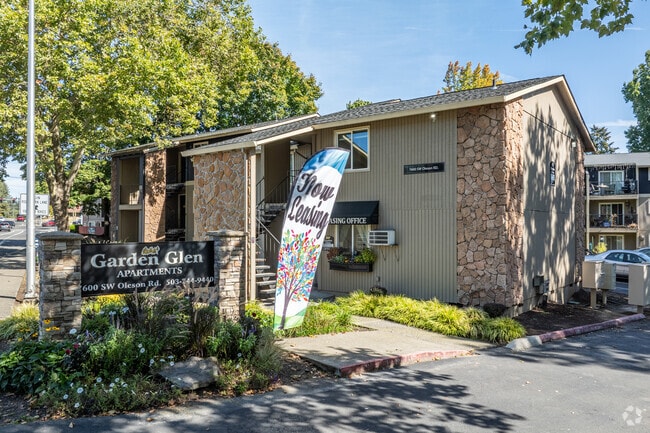
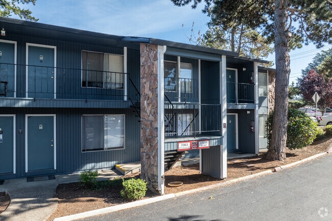
Property Detail
7620 Sw Oleson Rd
Portland-Vancouver-Hillsboro, OR-WA
NICHOLS ADDITION NO.2 TO GARDEN HOME, LOT PT 14, ACRES 0.92
R0220656
WASHINGTON
Apartment
Oregon
RM2
14
B and X Area of moderate flood hazard, usually the area between the limits of the 100-year and 500-year floods.
0.92 AC
2024
Raleigh Hills
2026
Portland
030900
NEARBY LISTINGS FOR SALE OR LEASE
DEMOGRAPHICS near 7620 Sw Oleson Rd
1 mile
3 mile
5 mile
2025 Total Population
12,747
125,594
342,403
2030 Population
12,797
125,590
344,214
Pop Growth 2025-2030
+ 0.39%
0.00%
+ 0.53%
Average Age
44
42
42
2025 Total Households
5,381
52,719
146,682
HH Growth 2025-2030
+ 0.39%
(0.01%)
+ 0.56%
Median Household Inc
$110,697
$100,028
$102,920
Avg Household Size
2.30
2.30
2.30
2025 Avg HH Vehicles
2.00
2.00
2.00
Median Home Value
$716,138
$686,730
$704,315
Median Year Built
1977
1975
1980
Nearby Places
Map Layers
Map Styles
 Street
 Aerial
Layers
 Traffic
 Biking
Places
Listings with unknown addresses are not visible on the map
- Restaurants
- Banks
- Shops
- Fitness
- Groceries
PUBLIC TRANSPORTATION
COMMUTER RAIL
Hall/Nimbus (Westside Express Service - Tri-County Metropolitan Transportation District of Oregon Rail (TriMet Rail))
Drive
Walk
Distance
Hall/Nimbus (Westside Express Service - Tri-County Metropolitan Transportation District of Oregon Rail (TriMet Rail))
5 min
2.1 mi
Tigard Transit Center (Westside Express Service - Tri-County Metropolitan Transportation District of Oregon Rail (TriMet Rail))
Drive
Walk
Distance
Tigard Transit Center (Westside Express Service - Tri-County Metropolitan Transportation District of Oregon Rail (TriMet Rail))
9 min
3.5 mi
AIRPORT
Portland International
Drive
Walk
Distance
Portland International
33 min
19.2 mi
Freight Ports
Port of Portland
Drive
Walk
Distance
Port of Portland
17 min
9.0 mi
Nearby Properties
Address
Land Use
TOTAL SIZE
Lot Size
Zoning
Address
Land Use
TOTAL SIZE
Lot Size
Zoning
828,566 SF
54.77 AC
CI2
Address
Land Use
TOTAL SIZE
Lot Size
Zoning
1 SF
16 AC
R-5
Address
Land Use
TOTAL SIZE
Lot Size
Zoning
175,880 SF
36.43 AC
OS
Address
Land Use
TOTAL SIZE
Lot Size
Zoning
14.77 AC
MUE
Address
Land Use
TOTAL SIZE
Lot Size
Zoning
79,646 SF
9.23 AC
R2R7
Address
Land Use
TOTAL SIZE
Lot Size
Zoning
155,201 SF
4.04 AC
R7
Address
Land Use
TOTAL SIZE
Lot Size
Zoning
256,070 SF
32.39 AC
R7
Address
Land Use
TOTAL SIZE
Lot Size
Zoning
43,537 SF
3.59 AC
MUC
Address
Land Use
TOTAL SIZE
Lot Size
Zoning
234,391 SF
0.13 AC
CS
Address
Land Use
TOTAL SIZE
Lot Size
Zoning
62,647 SF
9.65 AC
R7
Address
Land Use
TOTAL SIZE
Lot Size
Zoning
372,200 SF
34.75 AC
CS
Address
Land Use
TOTAL SIZE
Lot Size
Zoning
11,736 SF
2.85 AC
MUE-1
Address
Land Use
TOTAL SIZE
Lot Size
Zoning
285,650 SF
26.94 AC
INST
Address
Land Use
TOTAL SIZE
Lot Size
Zoning
5,724 SF
13.95 AC
NC/R-0
Address
Land Use
TOTAL SIZE
Lot Size
Zoning
423,095 SF
21.51 AC
R1
Address
Land Use
TOTAL SIZE
Lot Size
Zoning
159,473 SF
12.58 AC
RC-BC
Address
Land Use
TOTAL SIZE
Lot Size
Zoning
128,176 SF
25.06 AC
R7
Address
Land Use
TOTAL SIZE
Lot Size
Zoning
4,046 SF
4.08 AC
MUE-1
Address
Land Use
TOTAL SIZE
Lot Size
Zoning
301,940 SF
15.04 AC
MU-CBD
Address
Land Use
TOTAL SIZE
Lot Size
Zoning
87,200 SF
8.81 AC
R7
Address
Land Use
TOTAL SIZE
Lot Size
Zoning
517,403 SF
3.21 AC
MUE-1
Address
Land Use
TOTAL SIZE
Lot Size
Zoning
18.78 AC
R-15
Address
Land Use
TOTAL SIZE
Lot Size
Zoning
140,938 SF
7.02 AC
C-WS
Address
Land Use
TOTAL SIZE
Lot Size
Zoning
262,880 SF
0.95 AC
CX
Address
Land Use
TOTAL SIZE
Lot Size
Zoning
3.88 AC
CS
Address
Land Use
TOTAL SIZE
Lot Size
Zoning
Address
Land Use
TOTAL SIZE
Lot Size
Zoning
209,706 SF
4.89 AC
MUC
Address
Land Use
TOTAL SIZE
Lot Size
Zoning
0.09 AC
OI-WS
Address
Land Use
TOTAL SIZE
Lot Size
Zoning
517,596 SF
13.49 AC
MUC
Address
Land Use
TOTAL SIZE
Lot Size
Zoning
The World's #1 Commercial Real Estate Marketplace
Connect with us
© 2026 CoStar Group
The information above has been obtained from sources believed reliable. While we do not doubt its accuracy we have not verified it and make no guarantee, warranty or representation about it. It is your responsibility to independently confirm its accuracy and completeness. Any projections, opinions, assumptions, or estimates used are for example only and do not represent the current or future performance of the property. The value of this transaction to you depends on tax and other factors which should be evaluated by your tax, financial, and legal advisors. You and your advisors should conduct a careful, independent investigation of the property to determine to your satisfaction the suitability of the property for your needs.