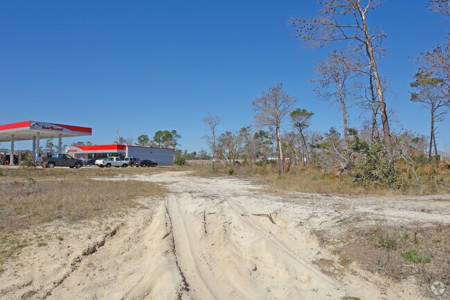
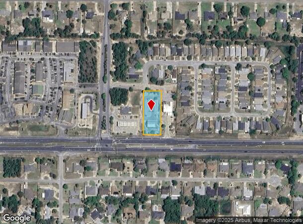
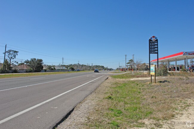
Property Record
7622 Navarre Pkwy, Navarre, FL 32566
NEARBY LISTINGS FOR SALE OR LEASE
Property Detail
7622 Navarre Pkwy
24-2S-27-0000-00503-0000
COM AT NE CORNER OF SECTION 24 TOWNSHP 2 SOUTH RANGE 27 WEST THN S08*5727E ALONG E SEC LN 2641.54 FT THN S80*2902W 548.55 FT THN S08*4908E 335.47 FT THN S80*1634W 372.27 FT TO POB & CONTINUE S80*1634W 120 FT THN S08*4908E 300 FT TO N R/W OF HWY 98 TH
Bartavern
Santa Rosa
X
Florida
12113C0569H
0.83 AC
2024
Navarre
2025
Pensacola
010821
Pensacola-Ferry Pass-Brent, FL
3,077 SF
DEMOGRAPHICS near 7622 Navarre Pkwy
1 Mile
3 Mile
5 Mile
2024 Total Population
5,163
31,995
52,611
2029 Population
5,893
37,064
61,068
Pop Growth 2024-2029
+ 14.14%
+ 15.84%
+ 16.07%
Average Age
38
40
40
2024 Total Households
2,058
12,202
19,890
HH Growth 2024-2029
+ 14.48%
+ 16.58%
+ 16.65%
Median Household Inc
$82,459
$95,772
$93,174
Avg Household Size
2.50
2.60
2.60
2024 Avg HH Vehicles
2.00
2.00
2.00
Median Home Value
$280,338
$321,470
$314,838
Median Year Built
2003
2002
2002
Nearby Places
Map Layers
Map Styles
 Street
 Aerial
- Restaurants
- Banks
- Shops
- Fitness
- Groceries
PUBLIC TRANSPORTATION
AIRPORT
Pensacola International
DRIVE
WALK
Distance
Pensacola International
47 min
27.3 mi
Eglin AFB/Destin-Ft Walton Beach
DRIVE
WALK
Distance
Eglin AFB/Destin-Ft Walton Beach
56 min
28.9 mi
Freight Ports
Port of Mobile
DRIVE
WALK
Distance
Port of Mobile
100 min
83.2 mi
Nearby Properties
Address
Land Use
TOTAL SIZE
Lot Size
Zoning
Address
Land Use
TOTAL SIZE
Lot Size
Zoning
344,974 SF
16.11 AC
R3
Address
Land Use
TOTAL SIZE
Lot Size
Zoning
375,552 SF
10.62 AC
PBD
Address
Land Use
TOTAL SIZE
Lot Size
Zoning
131,381 SF
8.84 AC
HNB
Address
Land Use
TOTAL SIZE
Lot Size
Zoning
131,381 SF
11.25 AC
HNB
Address
Land Use
TOTAL SIZE
Lot Size
Zoning
23.12 AC
C
Address
Land Use
TOTAL SIZE
Lot Size
Zoning
161,438 SF
5.64 AC
HCD
Address
Land Use
TOTAL SIZE
Lot Size
Zoning
68,134 SF
21.16 AC
R1
Address
Land Use
TOTAL SIZE
Lot Size
Zoning
116,452 SF
4.55 AC
HCD
Address
Land Use
TOTAL SIZE
Lot Size
Zoning
77,417 SF
8.06 AC
HCD
Address
Land Use
TOTAL SIZE
Lot Size
Zoning
65,936 SF
1.86 AC
PBD
Address
Land Use
TOTAL SIZE
Lot Size
Zoning
51,677 SF
17.79 AC
PBD
Address
Land Use
TOTAL SIZE
Lot Size
Zoning
68,334 SF
4.45 AC
HCD
Address
Land Use
TOTAL SIZE
Lot Size
Zoning
85,562 SF
36.21 AC
PBD
Address
Land Use
TOTAL SIZE
Lot Size
Zoning
19,350 SF
9.10 AC
HCD
Address
Land Use
TOTAL SIZE
Lot Size
Zoning
60,854 SF
7.07 AC
HCD
Address
Land Use
TOTAL SIZE
Lot Size
Zoning
14,448 SF
17.20 AC
P
Address
Land Use
TOTAL SIZE
Lot Size
Zoning
48,198 SF
1.76 AC
PBD
Address
Land Use
TOTAL SIZE
Lot Size
Zoning
130,030 SF
36.74 AC
R1A
Address
Land Use
TOTAL SIZE
Lot Size
Zoning
8,714 SF
7 AC
P2-HON
Address
Land Use
TOTAL SIZE
Lot Size
Zoning
39,373 SF
185.18 AC
R1
Address
Land Use
TOTAL SIZE
Lot Size
Zoning
2,046 SF
0.79 AC
HCD
Address
Land Use
TOTAL SIZE
Lot Size
Zoning
3.39 AC
NB-C
Address
Land Use
TOTAL SIZE
Lot Size
Zoning
14,208 SF
4.53 AC
HCD
Address
Land Use
TOTAL SIZE
Lot Size
Zoning
36,749 SF
2.75 AC
HCD
Address
Land Use
TOTAL SIZE
Lot Size
Zoning
26,192 SF
3.82 AC
HCD
Address
Land Use
TOTAL SIZE
Lot Size
Zoning
40,544 SF
2.26 AC
HCD
Address
Land Use
TOTAL SIZE
Lot Size
Zoning
24,025 SF
2.66 AC
HCD
Address
Land Use
TOTAL SIZE
Lot Size
Zoning
38,588 SF
4.82 AC
HCD
Address
Land Use
TOTAL SIZE
Lot Size
Zoning
400 SF
4.01 AC
HCD
The World's #1 Commercial Real Estate Marketplace
Connect with us
© 2025 CoStar Group
The information above has been obtained from sources believed reliable. While we do not doubt its accuracy we have not verified it and make no guarantee, warranty or representation about it. It is your responsibility to independently confirm its accuracy and completeness. Any projections, opinions, assumptions, or estimates used are for example only and do not represent the current or future performance of the property. The value of this transaction to you depends on tax and other factors which should be evaluated by your tax, financial, and legal advisors. You and your advisors should conduct a careful, independent investigation of the property to determine to your satisfaction the suitability of the property for your needs.