Property Record
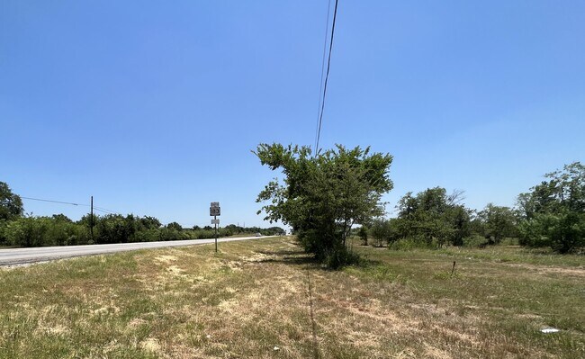
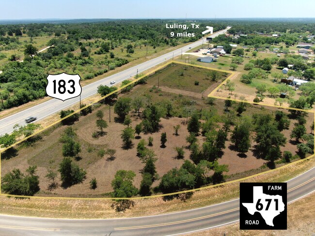
7627 S Us Highway 183, Lockhart, TX 78644
Property Detail
7627 S Us Highway 183
Austin-Round Rock-San Marcos, TX
VILLAGE AT MINERAL SPRINGS, LOT 4, ACRES 1.0
38956
CALDWELL
Residentialacreage
Texas
B and X Area of moderate flood hazard, usually the area between the limits of the 100-year and 500-year floods.
4
2025
1.01 AC
2025
Caldwell County
960102
Austin
NEARBY LISTINGS FOR SALE OR LEASE
DEMOGRAPHICS near 7627 S Us Highway 183
1 mile
3 mile
5 mile
2025 Total Population
283
1,867
13,931
2030 Population
321
2,131
15,812
Pop Growth 2025-2030
+ 13.43%
+ 14.14%
+ 13.50%
Average Age
39
39
40
2025 Total Households
91
652
4,616
HH Growth 2025-2030
+ 14.29%
+ 15.18%
+ 14.84%
Median Household Inc
$68,437
$77,913
$71,205
Avg Household Size
2.80
2.70
2.70
2025 Avg HH Vehicles
3.00
2.00
2.00
Median Home Value
$481,817
$287,499
$268,400
Median Year Built
1992
2001
1994
Nearby Places
Map Layers
Map Styles
 Street
 Aerial
Transit
 Traffic
 Biking
Places
Listings with unknown addresses are not visible on the map
- Restaurants
- Banks
- Shops
- Fitness
- Groceries
PUBLIC TRANSPORTATION
AIRPORT
Austin-Bergstrom International
Drive
Walk
Distance
Austin-Bergstrom International
38 min
28.9 mi
Freight Ports
Calhoun Port
Drive
Walk
Distance
Calhoun Port
143 min
120.6 mi
SALE & LEASE HISTORY
LISTING DATE
SALE/LEASE

Aug 01, 2022
For Sale
Nearby Properties
Address
Land Use
TOTAL SIZE
Lot Size
Zoning
Address
Land Use
TOTAL SIZE
Lot Size
Zoning
1,489 SF
105.83 AC
Address
Land Use
TOTAL SIZE
Lot Size
Zoning
271.12 AC
Address
Land Use
TOTAL SIZE
Lot Size
Zoning
18,750 SF
4.16 AC
Address
Land Use
TOTAL SIZE
Lot Size
Zoning
19,828 SF
5.02 AC
Address
Land Use
TOTAL SIZE
Lot Size
Zoning
122.28 AC
Address
Land Use
TOTAL SIZE
Lot Size
Zoning
Address
Land Use
TOTAL SIZE
Lot Size
Zoning
7,535 SF
2.40 AC
Address
Land Use
TOTAL SIZE
Lot Size
Zoning
11,100 SF
3.34 AC
Address
Land Use
TOTAL SIZE
Lot Size
Zoning
47.75 AC
Address
Land Use
TOTAL SIZE
Lot Size
Zoning
5,253 SF
3.04 AC
Address
Land Use
TOTAL SIZE
Lot Size
Zoning
3,968 SF
0.75 AC
Address
Land Use
TOTAL SIZE
Lot Size
Zoning
3,645 SF
0.35 AC
Address
Land Use
TOTAL SIZE
Lot Size
Zoning
2,916 SF
35.43 AC
Address
Land Use
TOTAL SIZE
Lot Size
Zoning
2,620 SF
20.84 AC
Address
Land Use
TOTAL SIZE
Lot Size
Zoning
8.46 AC
Address
Land Use
TOTAL SIZE
Lot Size
Zoning
4,299 SF
1.56 AC
Address
Land Use
TOTAL SIZE
Lot Size
Zoning
2,641 SF
7 AC
Address
Land Use
TOTAL SIZE
Lot Size
Zoning
6.58 AC
Address
Land Use
TOTAL SIZE
Lot Size
Zoning
6,420 SF
5.07 AC
Address
Land Use
TOTAL SIZE
Lot Size
Zoning
4,275 SF
1.48 AC
Address
Land Use
TOTAL SIZE
Lot Size
Zoning
38.55 AC
Address
Land Use
TOTAL SIZE
Lot Size
Zoning
21,060 SF
0.45 AC
Address
Land Use
TOTAL SIZE
Lot Size
Zoning
4,760 SF
12 AC
Address
Land Use
TOTAL SIZE
Lot Size
Zoning
2,154 SF
30.71 AC
Address
Land Use
TOTAL SIZE
Lot Size
Zoning
40.57 AC
Address
Land Use
TOTAL SIZE
Lot Size
Zoning
5,310 SF
6.26 AC
Address
Land Use
TOTAL SIZE
Lot Size
Zoning
15,001 SF
0.35 AC
Address
Land Use
TOTAL SIZE
Lot Size
Zoning
23.63 AC
Address
Land Use
TOTAL SIZE
Lot Size
Zoning
652 SF
122.88 AC
Address
Land Use
TOTAL SIZE
Lot Size
Zoning
31.38 AC
The World's #1 Commercial Real Estate Marketplace
Connect with us
© 2026 CoStar Group
The information above has been obtained from sources believed reliable. While we do not doubt its accuracy we have not verified it and make no guarantee, warranty or representation about it. It is your responsibility to independently confirm its accuracy and completeness. Any projections, opinions, assumptions, or estimates used are for example only and do not represent the current or future performance of the property. The value of this transaction to you depends on tax and other factors which should be evaluated by your tax, financial, and legal advisors. You and your advisors should conduct a careful, independent investigation of the property to determine to your satisfaction the suitability of the property for your needs.