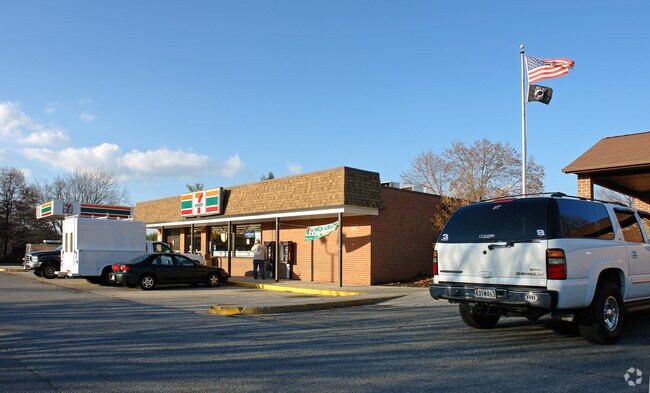
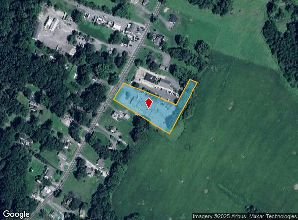
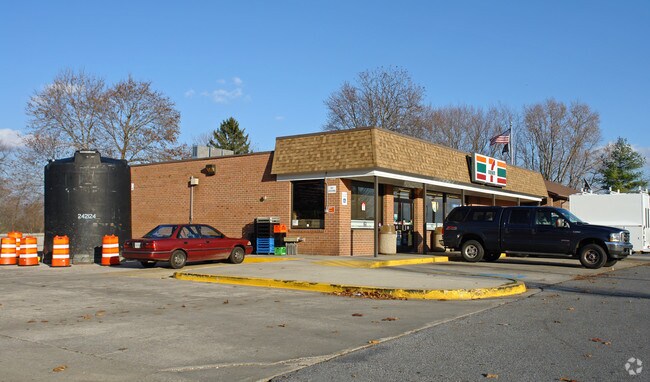
Property Record
7627 Woodbine Rd, Woodbine, MD 21797
NEARBY LISTINGS FOR SALE OR LEASE
-
-
View all Woodbine listings for sale on LoopNet.com
Property Detail
7627 Woodbine Rd
14-005080
Woodbine
Communitycenter
LT - 2 ACS E/S WINFIELD-WOODBINE RD WOODBINE
X
Carroll
24013C0381D
Maryland
2025
2 AC
2025
Carroll County
514201
Baltimore
9,200 SF
Baltimore-Columbia-Towson, MD
DEMOGRAPHICS near 7627 Woodbine Rd
1 Mile
3 Mile
5 Mile
2024 Total Population
1,073
6,846
29,321
2029 Population
1,099
7,005
30,142
Pop Growth 2024-2029
+ 2.42%
+ 2.32%
+ 2.80%
Average Age
42
43
42
2024 Total Households
374
2,362
10,131
HH Growth 2024-2029
+ 2.67%
+ 2.37%
+ 2.84%
Median Household Inc
$110,326
$136,332
$136,828
Avg Household Size
2.80
2.90
2.80
2024 Avg HH Vehicles
3.00
3.00
3.00
Median Home Value
$493,877
$587,926
$535,019
Median Year Built
1982
1981
1985
Nearby Places
Map Layers
Map Styles
 Street
 Aerial
- Restaurants
- Banks
- Shops
- Fitness
- Groceries
PUBLIC TRANSPORTATION
AIRPORT
Baltimore/Washington International Thurgood Marshall
DRIVE
WALK
Distance
Baltimore/Washington International Thurgood Marshall
43 min
31.0 mi
Freight Ports
Port of Baltimore
DRIVE
WALK
Distance
Port of Baltimore
43 min
31.3 mi
Nearby Properties
Address
Land Use
TOTAL SIZE
Lot Size
Zoning
Address
Land Use
TOTAL SIZE
Lot Size
Zoning
14,030 SF
14.02 AC
RCDEO
Address
Land Use
TOTAL SIZE
Lot Size
Zoning
9,130 SF
8.23 AC
RCDEO
Address
Land Use
TOTAL SIZE
Lot Size
Zoning
39.15 AC
I-2
Address
Land Use
TOTAL SIZE
Lot Size
Zoning
53.81 AC
I-2
Address
Land Use
TOTAL SIZE
Lot Size
Zoning
27,040 SF
11.58 AC
I-2
Address
Land Use
TOTAL SIZE
Lot Size
Zoning
25,333 SF
9.25 AC
RCDEO
Address
Land Use
TOTAL SIZE
Lot Size
Zoning
25,333 SF
14.29 AC
RCDEO
Address
Land Use
TOTAL SIZE
Lot Size
Zoning
10,832 SF
4.99 AC
RCDEO
Address
Land Use
TOTAL SIZE
Lot Size
Zoning
32,730 SF
11.81 AC
B2RCD
Address
Land Use
TOTAL SIZE
Lot Size
Zoning
30,367 SF
14.19 AC
B2RCD
Address
Land Use
TOTAL SIZE
Lot Size
Zoning
118.48 AC
CONSE
Address
Land Use
TOTAL SIZE
Lot Size
Zoning
9,384 SF
9 AC
RCDEO
Address
Land Use
TOTAL SIZE
Lot Size
Zoning
1,800 SF
66.61 AC
AGRIC
Address
Land Use
TOTAL SIZE
Lot Size
Zoning
14,272 SF
56.78 AC
AGRIC
Address
Land Use
TOTAL SIZE
Lot Size
Zoning
4,056 SF
17.16 AC
AGRIC
Address
Land Use
TOTAL SIZE
Lot Size
Zoning
5,112 SF
4.12 AC
RCDEO
Address
Land Use
TOTAL SIZE
Lot Size
Zoning
640 SF
34.92 AC
I-2
Address
Land Use
TOTAL SIZE
Lot Size
Zoning
1,615 SF
4.93 AC
I-2
Address
Land Use
TOTAL SIZE
Lot Size
Zoning
912 SF
65.37 AC
CONSE
Address
Land Use
TOTAL SIZE
Lot Size
Zoning
4,900 SF
7.59 AC
I-2
Address
Land Use
TOTAL SIZE
Lot Size
Zoning
4,800 SF
1.71 AC
I-2
Address
Land Use
TOTAL SIZE
Lot Size
Zoning
10,200 SF
9 AC
I-2
Address
Land Use
TOTAL SIZE
Lot Size
Zoning
2,520 SF
3.19 AC
I-2
Address
Land Use
TOTAL SIZE
Lot Size
Zoning
4,500 SF
1 AC
B2
Address
Land Use
TOTAL SIZE
Lot Size
Zoning
49 AC
CONSE
Address
Land Use
TOTAL SIZE
Lot Size
Zoning
2,035 SF
1.94 AC
RCDEO
Address
Land Use
TOTAL SIZE
Lot Size
Zoning
2,967 SF
3 AC
B2
Address
Land Use
TOTAL SIZE
Lot Size
Zoning
38.50 AC
CONSE
Address
Land Use
TOTAL SIZE
Lot Size
Zoning
5,000 SF
4.52 AC
I-2
Address
Land Use
TOTAL SIZE
Lot Size
Zoning
31.83 AC
CONSE
The World's #1 Commercial Real Estate Marketplace
Connect with us
© 2026 CoStar Group
The information above has been obtained from sources believed reliable. While we do not doubt its accuracy we have not verified it and make no guarantee, warranty or representation about it. It is your responsibility to independently confirm its accuracy and completeness. Any projections, opinions, assumptions, or estimates used are for example only and do not represent the current or future performance of the property. The value of this transaction to you depends on tax and other factors which should be evaluated by your tax, financial, and legal advisors. You and your advisors should conduct a careful, independent investigation of the property to determine to your satisfaction the suitability of the property for your needs.