Property Record
7629 State Route 5 And 20, Bloomfield, NY 14469
NEARBY LISTINGS FOR SALE OR LEASE
-
-
View all Bloomfield listings for lease on LoopNet.com
Property Detail
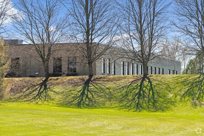
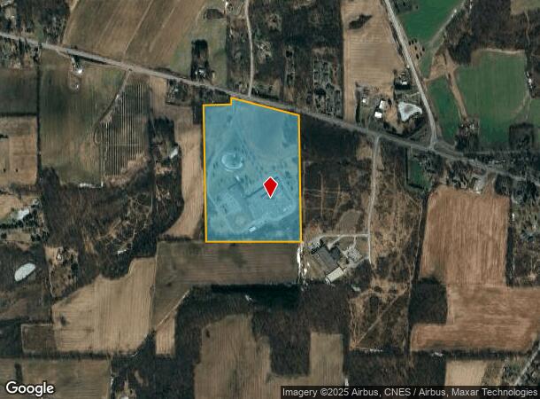
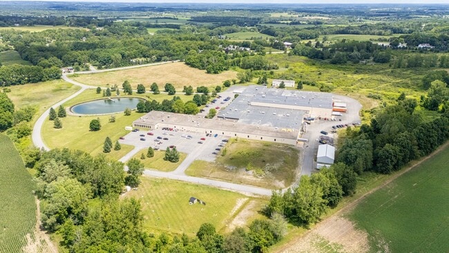
7629 State Route 5 And 20
Rochester, NY
Ontario
322689-080-000-0001-004-000
New York
Manufacturinglight
4.000
2025
49.70 AC
2024
Outlying Ontario County
050501
Rochester
249,040 SF
DEMOGRAPHICS near 7629 State Route 5 And 20
1 Mile
3 Mile
5 Mile
2024 Total Population
536
3,110
6,636
2029 Population
524
3,030
6,483
Pop Growth 2024-2029
(2.24%)
(2.57%)
(2.31%)
Average Age
44
45
45
2024 Total Households
225
1,304
2,717
HH Growth 2024-2029
(2.22%)
(2.68%)
(2.43%)
Median Household Inc
$84,134
$80,616
$84,394
Avg Household Size
2.30
2.30
2.40
2024 Avg HH Vehicles
2.00
2.00
2.00
Median Home Value
$186,428
$189,130
$222,246
Median Year Built
1959
1963
1971
Nearby Places
Map Layers
Map Styles
 Street
 Aerial
- Restaurants
- Banks
- Shops
- Fitness
- Groceries
PUBLIC TRANSPORTATION
AIRPORT
Frederick Douglass/Greater Rochester International
DRIVE
WALK
Distance
Frederick Douglass/Greater Rochester International
44 min
25.6 mi
Freight Ports
Albany, NY Port
DRIVE
WALK
Distance
Albany, NY Port
263 min
218.6 mi
SALE & LEASE HISTORY
LISTING DATE
SALE/LEASE

Jan 20, 2025
For Lease
Nearby Properties
Address
Land Use
TOTAL SIZE
Lot Size
Zoning
Address
Land Use
TOTAL SIZE
Lot Size
Zoning
99,012 SF
24.20 AC
R-1-15
Address
Land Use
TOTAL SIZE
Lot Size
Zoning
780 SF
73.60 AC
Address
Land Use
TOTAL SIZE
Lot Size
Zoning
10,080 SF
10.20 AC
GI
Address
Land Use
TOTAL SIZE
Lot Size
Zoning
Address
Land Use
TOTAL SIZE
Lot Size
Zoning
90,471 SF
11 AC
R-1-15
Address
Land Use
TOTAL SIZE
Lot Size
Zoning
Address
Land Use
TOTAL SIZE
Lot Size
Zoning
10,965 SF
1.70 AC
GI
Address
Land Use
TOTAL SIZE
Lot Size
Zoning
99,316 SF
12 AC
GI
Address
Land Use
TOTAL SIZE
Lot Size
Zoning
18,646 SF
1.40 AC
R120
Address
Land Use
TOTAL SIZE
Lot Size
Zoning
6,048 SF
3.50 AC
R120
Address
Land Use
TOTAL SIZE
Lot Size
Zoning
329 AC
AR-2
Address
Land Use
TOTAL SIZE
Lot Size
Zoning
2,860 SF
5.40 AC
MR
Address
Land Use
TOTAL SIZE
Lot Size
Zoning
1,360 SF
3.40 AC
R-1-20
Address
Land Use
TOTAL SIZE
Lot Size
Zoning
3,120 SF
4.50 AC
R120
Address
Land Use
TOTAL SIZE
Lot Size
Zoning
Address
Land Use
TOTAL SIZE
Lot Size
Zoning
Address
Land Use
TOTAL SIZE
Lot Size
Zoning
880 SF
5.40 AC
R120
Address
Land Use
TOTAL SIZE
Lot Size
Zoning
Address
Land Use
TOTAL SIZE
Lot Size
Zoning
Address
Land Use
TOTAL SIZE
Lot Size
Zoning
Address
Land Use
TOTAL SIZE
Lot Size
Zoning
9,300 SF
1.50 AC
05 - COMME
Address
Land Use
TOTAL SIZE
Lot Size
Zoning
Address
Land Use
TOTAL SIZE
Lot Size
Zoning
Address
Land Use
TOTAL SIZE
Lot Size
Zoning
1,080 SF
311.50 AC
AR2
Address
Land Use
TOTAL SIZE
Lot Size
Zoning
31,850 SF
9.70 AC
CC
Address
Land Use
TOTAL SIZE
Lot Size
Zoning
3,209 SF
1.80 AC
VC
Address
Land Use
TOTAL SIZE
Lot Size
Zoning
Address
Land Use
TOTAL SIZE
Lot Size
Zoning
10,270 SF
5.10 AC
MR
Address
Land Use
TOTAL SIZE
Lot Size
Zoning
The World's #1 Commercial Real Estate Marketplace
Connect with us
© 2025 CoStar Group
The information above has been obtained from sources believed reliable. While we do not doubt its accuracy we have not verified it and make no guarantee, warranty or representation about it. It is your responsibility to independently confirm its accuracy and completeness. Any projections, opinions, assumptions, or estimates used are for example only and do not represent the current or future performance of the property. The value of this transaction to you depends on tax and other factors which should be evaluated by your tax, financial, and legal advisors. You and your advisors should conduct a careful, independent investigation of the property to determine to your satisfaction the suitability of the property for your needs.