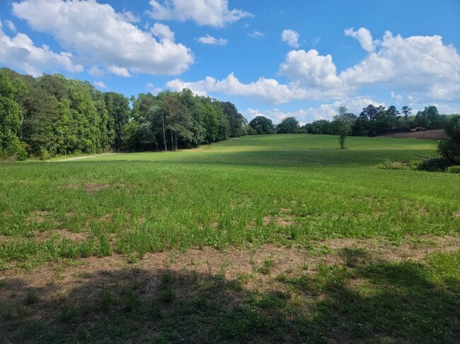
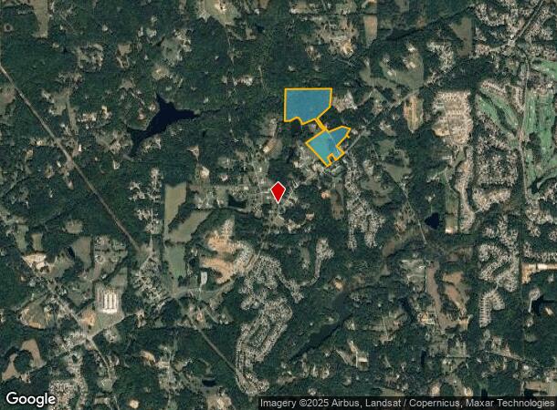
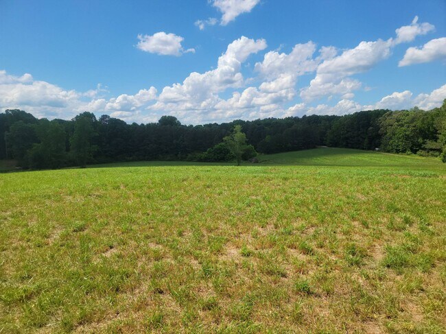
Property Record
7631 E Cherokee Dr, Canton, GA 30115
NEARBY LISTINGS FOR SALE OR LEASE
Property Detail
7631 E Cherokee Dr
003N12-00000-038-00A-0000
Collett Family Llc Surv
Agriculturalland
LL 1070, 1071, 1090 & 1091 3RD D TR A
A
Cherokee
13057C0260E
Georgia
2025
39.53 AC
2025
Cherokee County
090603
Atlanta
1,485 SF
Atlanta-Sandy Springs-Roswell, GA
DEMOGRAPHICS near 7631 E Cherokee Dr
1 Mile
3 Mile
5 Mile
2024 Total Population
2,024
16,007
36,200
2029 Population
2,290
18,248
41,166
Pop Growth 2024-2029
+ 13.14%
+ 14.00%
+ 13.72%
Average Age
40
41
41
2024 Total Households
667
5,350
12,156
HH Growth 2024-2029
+ 13.19%
+ 14.11%
+ 13.89%
Median Household Inc
$124,731
$121,463
$122,751
Avg Household Size
3.00
3.00
2.90
2024 Avg HH Vehicles
2.00
2.00
2.00
Median Home Value
$384,249
$449,036
$455,962
Median Year Built
2002
2002
2002
Nearby Places
Map Layers
Map Styles
 Street
 Aerial
- Restaurants
- Banks
- Shops
- Fitness
- Groceries
SALE & LEASE HISTORY
LISTING DATE
SALE/LEASE

Jul 31, 2023
For Sale
Nearby Properties
Address
Land Use
TOTAL SIZE
Lot Size
Zoning
Address
Land Use
TOTAL SIZE
Lot Size
Zoning
472,267 SF
90.24 AC
AG
Address
Land Use
TOTAL SIZE
Lot Size
Zoning
178,576 SF
13.74 AC
GC
Address
Land Use
TOTAL SIZE
Lot Size
Zoning
133,843 SF
31.69 AC
AG
Address
Land Use
TOTAL SIZE
Lot Size
Zoning
95,102 SF
19.53 AC
AG
Address
Land Use
TOTAL SIZE
Lot Size
Zoning
69,966 SF
22.62 AC
GC
Address
Land Use
TOTAL SIZE
Lot Size
Zoning
81,240 SF
10.20 AC
GC
Address
Land Use
TOTAL SIZE
Lot Size
Zoning
39,657 SF
149.32 AC
AG
Address
Land Use
TOTAL SIZE
Lot Size
Zoning
85,610 SF
9.76 AC
GC
Address
Land Use
TOTAL SIZE
Lot Size
Zoning
33,545 SF
182.62 AC
PUD
Address
Land Use
TOTAL SIZE
Lot Size
Zoning
960 SF
78.30 AC
R-15
Address
Land Use
TOTAL SIZE
Lot Size
Zoning
51,216 SF
11.31 AC
GC
Address
Land Use
TOTAL SIZE
Lot Size
Zoning
22,729 SF
4.05 AC
AG
Address
Land Use
TOTAL SIZE
Lot Size
Zoning
7,284 SF
62.19 AC
AG
Address
Land Use
TOTAL SIZE
Lot Size
Zoning
6,080 SF
9.91 AC
GC
Address
Land Use
TOTAL SIZE
Lot Size
Zoning
115.24 AC
R-40
Address
Land Use
TOTAL SIZE
Lot Size
Zoning
30,557 SF
9.88 AC
R-80
Address
Land Use
TOTAL SIZE
Lot Size
Zoning
17,310 SF
3.65 AC
GC
Address
Land Use
TOTAL SIZE
Lot Size
Zoning
8.98 AC
LI
Address
Land Use
TOTAL SIZE
Lot Size
Zoning
4,285 SF
38.58 AC
AG
Address
Land Use
TOTAL SIZE
Lot Size
Zoning
1,300 SF
49.84 AC
R-80
Address
Land Use
TOTAL SIZE
Lot Size
Zoning
37.77 AC
AG
Address
Land Use
TOTAL SIZE
Lot Size
Zoning
5,757 SF
1.94 AC
GC
Address
Land Use
TOTAL SIZE
Lot Size
Zoning
12,252 SF
4.89 AC
AG
Address
Land Use
TOTAL SIZE
Lot Size
Zoning
49.36 AC
AG
Address
Land Use
TOTAL SIZE
Lot Size
Zoning
46.11 AC
R-30
Address
Land Use
TOTAL SIZE
Lot Size
Zoning
17 AC
R-80
Address
Land Use
TOTAL SIZE
Lot Size
Zoning
89.24 AC
AG
Address
Land Use
TOTAL SIZE
Lot Size
Zoning
5,775 SF
1.03 AC
GC
Address
Land Use
TOTAL SIZE
Lot Size
Zoning
12,760 SF
4.80 AC
NC
The World's #1 Commercial Real Estate Marketplace
Connect with us
© 2025 CoStar Group
The information above has been obtained from sources believed reliable. While we do not doubt its accuracy we have not verified it and make no guarantee, warranty or representation about it. It is your responsibility to independently confirm its accuracy and completeness. Any projections, opinions, assumptions, or estimates used are for example only and do not represent the current or future performance of the property. The value of this transaction to you depends on tax and other factors which should be evaluated by your tax, financial, and legal advisors. You and your advisors should conduct a careful, independent investigation of the property to determine to your satisfaction the suitability of the property for your needs.