Property Record
7634 Mclaughlin Rd, Peyton, CO 80831
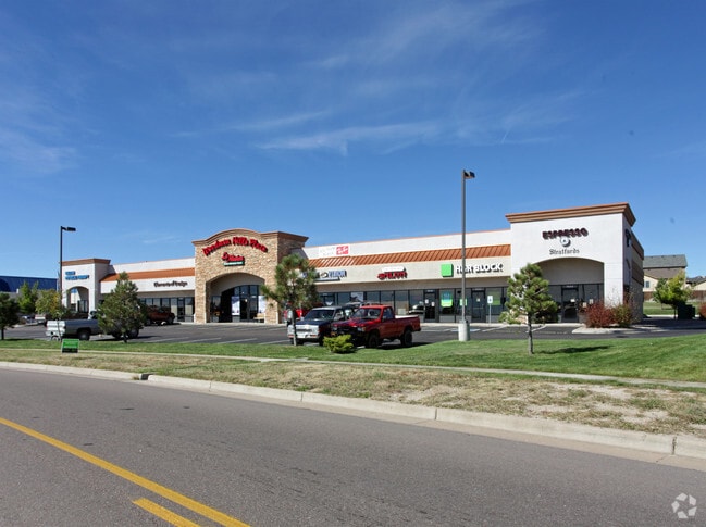

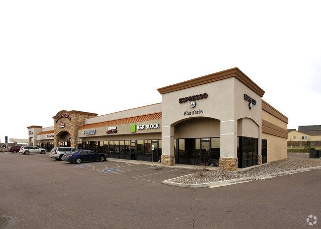

Property Detail
7634 Mclaughlin Rd
43063-17-002
LOT 1 WOODMEN HILLS FIL NO 7G
Commercialbuilding
EL PASO
CR
Colorado
B and X Area of moderate flood hazard, usually the area between the limits of the 100-year and 500-year floods.
1
2024
1.70 AC
2025
Northeast
005122
Colorado Springs
11,400 SF
Colorado Springs, CO
NEARBY LISTINGS FOR SALE OR LEASE
DEMOGRAPHICS near 7634 Mclaughlin Rd
1 mile
3 mile
5 mile
2025 Total Population
4,926
23,599
51,970
2030 Population
4,979
24,229
53,984
Pop Growth 2025-2030
+ 1.08%
+ 2.67%
+ 3.88%
Average Age
37
36
36
2025 Total Households
1,619
7,457
16,860
HH Growth 2025-2030
+ 1.42%
+ 2.90%
+ 4.11%
Median Household Inc
$116,011
$134,375
$133,881
Avg Household Size
3.00
3.10
3.10
2025 Avg HH Vehicles
3.00
3.00
2.00
Median Home Value
$499,606
$577,275
$611,857
Median Year Built
2004
2007
2010
Nearby Places
Map Layers
Map Styles
 Street
 Aerial
Transit
 Traffic
 Biking
Places
Listings with unknown addresses are not visible on the map
- Restaurants
- Banks
- Shops
- Fitness
- Groceries
PUBLIC TRANSPORTATION
AIRPORT
City of Colorado Springs Municipal
Drive
Walk
Distance
City of Colorado Springs Municipal
22 min
11.6 mi
Freight Ports
Tulsa Port Of Catoosa
Drive
Walk
Distance
Tulsa Port Of Catoosa
717 min
679.1 mi
Nearby Properties
Address
Land Use
TOTAL SIZE
Lot Size
Zoning
Address
Land Use
TOTAL SIZE
Lot Size
Zoning
43,256 SF
4.49 AC
PUD
Address
Land Use
TOTAL SIZE
Lot Size
Zoning
43,256 SF
4.73 AC
Address
Land Use
TOTAL SIZE
Lot Size
Zoning
39,446 SF
10.71 AC
RR-5
Address
Land Use
TOTAL SIZE
Lot Size
Zoning
123,673 SF
9.98 AC
CR
Address
Land Use
TOTAL SIZE
Lot Size
Zoning
195,448 SF
19.86 AC
CR
Address
Land Use
TOTAL SIZE
Lot Size
Zoning
46,935 SF
13.62 AC
PUD
Address
Land Use
TOTAL SIZE
Lot Size
Zoning
16,915 SF
5.19 AC
PUD
Address
Land Use
TOTAL SIZE
Lot Size
Zoning
7,573 SF
757.70 AC
PUD R-4 R-
Address
Land Use
TOTAL SIZE
Lot Size
Zoning
16,455 SF
6.89 AC
A-35 RR-2.
Address
Land Use
TOTAL SIZE
Lot Size
Zoning
15,406 SF
5.42 AC
RR-5
Address
Land Use
TOTAL SIZE
Lot Size
Zoning
10,017 SF
1.50 AC
CR
Address
Land Use
TOTAL SIZE
Lot Size
Zoning
13,048 SF
1.63 AC
CR
Address
Land Use
TOTAL SIZE
Lot Size
Zoning
3,148 SF
0.58 AC
CR
Address
Land Use
TOTAL SIZE
Lot Size
Zoning
38,804 SF
39.37 AC
RR-5
Address
Land Use
TOTAL SIZE
Lot Size
Zoning
41,592 SF
8.59 AC
RR-5
Address
Land Use
TOTAL SIZE
Lot Size
Zoning
6,289 SF
2.04 AC
CC
Address
Land Use
TOTAL SIZE
Lot Size
Zoning
5,970 SF
35.54 AC
RR-2.5
Address
Land Use
TOTAL SIZE
Lot Size
Zoning
12,111 SF
2.54 AC
PUD
Address
Land Use
TOTAL SIZE
Lot Size
Zoning
29,113 SF
3.43 AC
CR
Address
Land Use
TOTAL SIZE
Lot Size
Zoning
8,788 SF
35.90 AC
RR-5
Address
Land Use
TOTAL SIZE
Lot Size
Zoning
8,134 SF
10.19 AC
I-2
Address
Land Use
TOTAL SIZE
Lot Size
Zoning
26,235 SF
2.93 AC
CR
Address
Land Use
TOTAL SIZE
Lot Size
Zoning
85,148 SF
8.12 AC
I-2
Address
Land Use
TOTAL SIZE
Lot Size
Zoning
4,957 SF
1.77 AC
CR RS-2000
Address
Land Use
TOTAL SIZE
Lot Size
Zoning
9,901 SF
2.49 AC
CR
Address
Land Use
TOTAL SIZE
Lot Size
Zoning
22,680 SF
2.84 AC
CR
Address
Land Use
TOTAL SIZE
Lot Size
Zoning
13,954 SF
4.78 AC
RR-5
Address
Land Use
TOTAL SIZE
Lot Size
Zoning
55,980 SF
5.95 AC
CR
Address
Land Use
TOTAL SIZE
Lot Size
Zoning
160 AC
RR-5
Address
Land Use
TOTAL SIZE
Lot Size
Zoning
1.46 AC
CR
The World's #1 Commercial Real Estate Marketplace
Connect with us
© 2026 CoStar Group
The information above has been obtained from sources believed reliable. While we do not doubt its accuracy we have not verified it and make no guarantee, warranty or representation about it. It is your responsibility to independently confirm its accuracy and completeness. Any projections, opinions, assumptions, or estimates used are for example only and do not represent the current or future performance of the property. The value of this transaction to you depends on tax and other factors which should be evaluated by your tax, financial, and legal advisors. You and your advisors should conduct a careful, independent investigation of the property to determine to your satisfaction the suitability of the property for your needs.