Property Record
76346 Barton Rd, Rainier, OR 97048
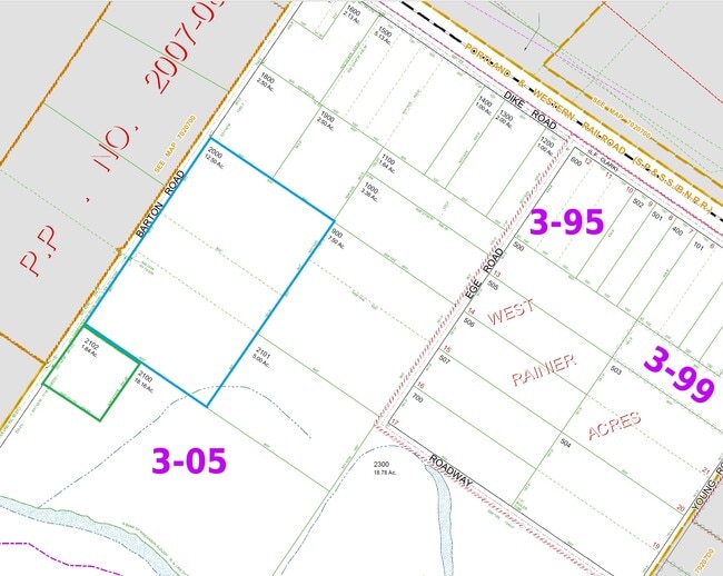


Property Detail
76346 Barton Rd
19458
COLUMBIA
Agriculturalland
Oregon
CO:M-2
1.84 AC
2025
Columbia County
2025
Portland
970300
Portland-Vancouver-Hillsboro, OR-WA
8,982 SF
NEARBY LISTINGS FOR SALE OR LEASE
DEMOGRAPHICS near 76346 Barton Rd
1 mile
3 mile
5 mile
2025 Total Population
245
15,797
51,386
2030 Population
251
16,052
52,291
Pop Growth 2025-2030
+ 2.45%
+ 1.61%
+ 1.76%
Average Age
45
40
41
2025 Total Households
97
6,019
20,863
HH Growth 2025-2030
+ 2.06%
+ 1.68%
+ 1.91%
Median Household Inc
$64,615
$59,612
$63,137
Avg Household Size
2.50
2.50
2.40
2025 Avg HH Vehicles
2.00
2.00
2.00
Median Home Value
$450,000
$317,656
$358,776
Median Year Built
1985
1955
1966
Nearby Places
Map Layers
Map Styles
 Street
 Aerial
Transit
 Traffic
 Biking
Places
Listings with unknown addresses are not visible on the map
- Restaurants
- Banks
- Shops
- Fitness
- Groceries
PUBLIC TRANSPORTATION
COMMUTER RAIL
Kelso-Longview (Amtrak Cascades - Amtrak, Coast Starlight - Amtrak)
Drive
Walk
Distance
Kelso-Longview (Amtrak Cascades - Amtrak, Coast Starlight - Amtrak)
18 min
7.3 mi
Freight Ports
Port of Long View, WA
Drive
Walk
Distance
Port of Long View, WA
11 min
4.2 mi
SALE & LEASE HISTORY
LISTING DATE
SALE/LEASE

May 20, 2025
For Lease
Nearby Properties
Address
Land Use
TOTAL SIZE
Lot Size
Zoning
Address
Land Use
TOTAL SIZE
Lot Size
Zoning
285.30 AC
MH0
Address
Land Use
TOTAL SIZE
Lot Size
Zoning
84.34 AC
MH0
Address
Land Use
TOTAL SIZE
Lot Size
Zoning
128.42 AC
Address
Land Use
TOTAL SIZE
Lot Size
Zoning
40.70 AC
MH0
Address
Land Use
TOTAL SIZE
Lot Size
Zoning
13.29 AC
Address
Land Use
TOTAL SIZE
Lot Size
Zoning
23.75 AC
M02
Address
Land Use
TOTAL SIZE
Lot Size
Zoning
179.05 AC
Address
Land Use
TOTAL SIZE
Lot Size
Zoning
81.40 AC
RN:M-1
Address
Land Use
TOTAL SIZE
Lot Size
Zoning
139,660 SF
2.76 AC
Address
Land Use
TOTAL SIZE
Lot Size
Zoning
206,926 SF
4.80 AC
C02
Address
Land Use
TOTAL SIZE
Lot Size
Zoning
1 SF
76.14 AC
MH0
Address
Land Use
TOTAL SIZE
Lot Size
Zoning
1 SF
88.15 AC
M01
Address
Land Use
TOTAL SIZE
Lot Size
Zoning
106.19 AC
M01
Address
Land Use
TOTAL SIZE
Lot Size
Zoning
271.55 AC
Address
Land Use
TOTAL SIZE
Lot Size
Zoning
1 SF
34.61 AC
Address
Land Use
TOTAL SIZE
Lot Size
Zoning
1 SF
43.48 AC
MH0
Address
Land Use
TOTAL SIZE
Lot Size
Zoning
50.37 AC
MH0
Address
Land Use
TOTAL SIZE
Lot Size
Zoning
20.90 AC
MH0
Address
Land Use
TOTAL SIZE
Lot Size
Zoning
4.46 AC
R03
Address
Land Use
TOTAL SIZE
Lot Size
Zoning
5.80 AC
MH0
Address
Land Use
TOTAL SIZE
Lot Size
Zoning
104,626 SF
8.26 AC
R01
Address
Land Use
TOTAL SIZE
Lot Size
Zoning
45,579 SF
3.87 AC
R01
Address
Land Use
TOTAL SIZE
Lot Size
Zoning
86.81 AC
MH0
Address
Land Use
TOTAL SIZE
Lot Size
Zoning
13,076 SF
17.67 AC
RPD
Address
Land Use
TOTAL SIZE
Lot Size
Zoning
38,880 SF
1.83 AC
M1A
Address
Land Use
TOTAL SIZE
Lot Size
Zoning
49,620 SF
10.42 AC
R01
Address
Land Use
TOTAL SIZE
Lot Size
Zoning
41.57 AC
MH0
Address
Land Use
TOTAL SIZE
Lot Size
Zoning
39,532 SF
6.94 AC
M1A
Address
Land Use
TOTAL SIZE
Lot Size
Zoning
1 SF
9.89 AC
Address
Land Use
TOTAL SIZE
Lot Size
Zoning
23.41 AC
CO:M-1
The World's #1 Commercial Real Estate Marketplace
Connect with us
© 2026 CoStar Group
The information above has been obtained from sources believed reliable. While we do not doubt its accuracy we have not verified it and make no guarantee, warranty or representation about it. It is your responsibility to independently confirm its accuracy and completeness. Any projections, opinions, assumptions, or estimates used are for example only and do not represent the current or future performance of the property. The value of this transaction to you depends on tax and other factors which should be evaluated by your tax, financial, and legal advisors. You and your advisors should conduct a careful, independent investigation of the property to determine to your satisfaction the suitability of the property for your needs.