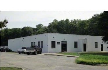
Property Record
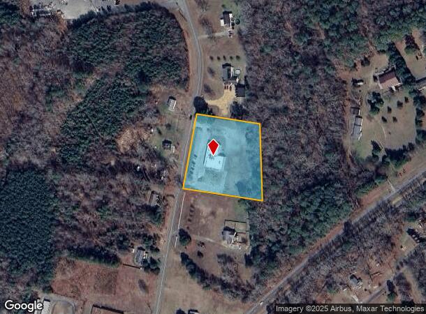
7639 Crab Thicket Rd, Gloucester, VA 23061

NEARBY LISTINGS FOR SALE OR LEASE
Property Detail
7639 Crab Thicket Rd
44014
Plat: Pb6 15
Daycare
INDIAN RD
X
Gloucester
51073C0120F
Virginia
2025
2.50 AC
2025
Gloucester
100201
Hampton Roads
7,300 SF
Virginia Beach-Norfolk-Newport News, VA-NC
DEMOGRAPHICS near 7639 Crab Thicket Rd
1 Mile
3 Mile
5 Mile
2024 Total Population
1,852
8,247
14,325
2029 Population
1,939
8,621
14,970
Pop Growth 2024-2029
+ 4.70%
+ 4.53%
+ 4.50%
Average Age
45
44
44
2024 Total Households
690
3,162
5,572
HH Growth 2024-2029
+ 4.64%
+ 4.46%
+ 4.43%
Median Household Inc
$84,692
$78,383
$79,823
Avg Household Size
2.50
2.50
2.50
2024 Avg HH Vehicles
2.00
2.00
2.00
Median Home Value
$270,111
$284,382
$280,221
Median Year Built
1988
1990
1988
Nearby Places
Map Layers
Map Styles
 Street
 Aerial
- Restaurants
- Banks
- Shops
- Fitness
- Groceries
PUBLIC TRANSPORTATION
AIRPORT
Newport News/Williamsburg International
DRIVE
WALK
Distance
Newport News/Williamsburg International
38 min
23.7 mi
Freight Ports
Virginia Port Authority - Newport News
DRIVE
WALK
Distance
Virginia Port Authority - Newport News
55 min
37.0 mi
SALE & LEASE HISTORY
LISTING DATE
SALE/LEASE

Sep 25, 2016
For Lease
Nearby Properties
Address
Land Use
TOTAL SIZE
Lot Size
Zoning
Address
Land Use
TOTAL SIZE
Lot Size
Zoning
70,334 SF
18.98 AC
B-1
Address
Land Use
TOTAL SIZE
Lot Size
Zoning
49,507 SF
56.81 AC
SC-1
Address
Land Use
TOTAL SIZE
Lot Size
Zoning
223,593 SF
21.45 AC
B-1
Address
Land Use
TOTAL SIZE
Lot Size
Zoning
16,980 SF
19.50 AC
B-2
Address
Land Use
TOTAL SIZE
Lot Size
Zoning
9.77 AC
B-1
Address
Land Use
TOTAL SIZE
Lot Size
Zoning
16,889 SF
7.52 AC
SF-1
Address
Land Use
TOTAL SIZE
Lot Size
Zoning
87,604 SF
16.14 AC
B-1
Address
Land Use
TOTAL SIZE
Lot Size
Zoning
7,508 SF
1,472.14 AC
RC-1
Address
Land Use
TOTAL SIZE
Lot Size
Zoning
104,911 SF
21.38 AC
B-1
Address
Land Use
TOTAL SIZE
Lot Size
Zoning
59,580 SF
41.98 AC
SC-1
Address
Land Use
TOTAL SIZE
Lot Size
Zoning
37,200 SF
6.37 AC
B-2
Address
Land Use
TOTAL SIZE
Lot Size
Zoning
110,191 SF
23.37 AC
B-1
Address
Land Use
TOTAL SIZE
Lot Size
Zoning
78,198 SF
11.16 AC
B-1
Address
Land Use
TOTAL SIZE
Lot Size
Zoning
41,528 SF
1.61 AC
B-1
Address
Land Use
TOTAL SIZE
Lot Size
Zoning
49,849 SF
4.24 AC
B-1
Address
Land Use
TOTAL SIZE
Lot Size
Zoning
70,334 SF
18.98 AC
B-1
Address
Land Use
TOTAL SIZE
Lot Size
Zoning
38,538 SF
6.09 AC
SF-1
Address
Land Use
TOTAL SIZE
Lot Size
Zoning
72,837 SF
6.40 AC
B-2
Address
Land Use
TOTAL SIZE
Lot Size
Zoning
38,928 SF
5.60 AC
B-1
Address
Land Use
TOTAL SIZE
Lot Size
Zoning
12,707 SF
3.22 AC
B-2
Address
Land Use
TOTAL SIZE
Lot Size
Zoning
7,134 SF
21.46 AC
SC-1
Address
Land Use
TOTAL SIZE
Lot Size
Zoning
6.56 AC
B-1
Address
Land Use
TOTAL SIZE
Lot Size
Zoning
11,174 SF
7 AC
B-1
Address
Land Use
TOTAL SIZE
Lot Size
Zoning
5 AC
SC-1
Address
Land Use
TOTAL SIZE
Lot Size
Zoning
57,180 SF
5.66 AC
B-1
Address
Land Use
TOTAL SIZE
Lot Size
Zoning
39,158 SF
1.02 AC
B-1
Address
Land Use
TOTAL SIZE
Lot Size
Zoning
15,968 SF
2.45 AC
B-1
Address
Land Use
TOTAL SIZE
Lot Size
Zoning
1.11 AC
B-1
Address
Land Use
TOTAL SIZE
Lot Size
Zoning
1.29 AC
SF-1
Address
Land Use
TOTAL SIZE
Lot Size
Zoning
3.60 AC
MF-1
The World's #1 Commercial Real Estate Marketplace
Connect with us
© 2025 CoStar Group
The information above has been obtained from sources believed reliable. While we do not doubt its accuracy we have not verified it and make no guarantee, warranty or representation about it. It is your responsibility to independently confirm its accuracy and completeness. Any projections, opinions, assumptions, or estimates used are for example only and do not represent the current or future performance of the property. The value of this transaction to you depends on tax and other factors which should be evaluated by your tax, financial, and legal advisors. You and your advisors should conduct a careful, independent investigation of the property to determine to your satisfaction the suitability of the property for your needs.