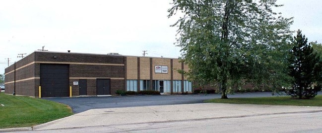
Property Record
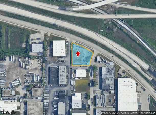
764 Thomas Dr, Bensenville, IL 60106

Current Lease Availabilities
NEARBY LISTINGS FOR SALE OR LEASE
Property Detail
764 Thomas Dr
Chicago-Naperville-Elgin, IL-IN-WI
Klefstads Bensenville Ind Pk
03-11-200-049
KLEFSTADS BENSENVILLE INDUSTRIAL PARK /EX HWY DESC 2014ED41/
Industrialgeneral
DuPage
X
Illinois
17043C0077J
41
2024
1.09 AC
2024
O'Hare
840000
Chicago
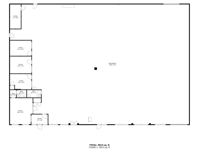
19,200 SF
DEMOGRAPHICS near 764 Thomas Dr
1 Mile
3 Mile
5 Mile
2024 Total Population
1,049
42,066
211,537
2029 Population
1,044
40,877
205,362
Pop Growth 2024-2029
(0.48%)
(2.83%)
(2.92%)
Average Age
36
40
41
2024 Total Households
328
14,922
77,474
HH Growth 2024-2029
(0.61%)
(2.99%)
(3.20%)
Median Household Inc
$75,833
$76,677
$76,609
Avg Household Size
3.10
2.70
2.60
2024 Avg HH Vehicles
2.00
2.00
2.00
Median Home Value
$254,861
$263,199
$281,902
Median Year Built
1974
1970
1968
Nearby Places
- Restaurants
- Banks
- Shops
- Fitness
- Groceries
PUBLIC TRANSPORTATION
COMMUTER RAIL
Bensenville Station (Milwaukee District West Line - Northeast Illinois Regional Commuter Railroad (Metra))
DRIVE
WALK
Distance
Bensenville Station (Milwaukee District West Line - Northeast Illinois Regional Commuter Railroad (Metra))
4 min
1.9 mi
Wood Dale Station (Milwaukee District West Line - Northeast Illinois Regional Commuter Railroad (Metra))
DRIVE
WALK
Distance
Wood Dale Station (Milwaukee District West Line - Northeast Illinois Regional Commuter Railroad (Metra))
6 min
3.3 mi
AIRPORT
Chicago O'Hare International
DRIVE
WALK
Distance
Chicago O'Hare International
24 min
5.9 mi
Chicago Midway International
DRIVE
WALK
Distance
Chicago Midway International
43 min
22.1 mi
Nearby Properties
Address
Land Use
TOTAL SIZE
Lot Size
Zoning
Address
Land Use
TOTAL SIZE
Lot Size
Zoning
108,216 SF
7.87 AC
Address
Land Use
TOTAL SIZE
Lot Size
Zoning
Address
Land Use
TOTAL SIZE
Lot Size
Zoning
310,751 SF
15.04 AC
Address
Land Use
TOTAL SIZE
Lot Size
Zoning
333,258 SF
9.48 AC
Address
Land Use
TOTAL SIZE
Lot Size
Zoning
Address
Land Use
TOTAL SIZE
Lot Size
Zoning
179,780 SF
8.12 AC
I
Address
Land Use
TOTAL SIZE
Lot Size
Zoning
58,373 SF
11.22 AC
Address
Land Use
TOTAL SIZE
Lot Size
Zoning
17.67 AC
Address
Land Use
TOTAL SIZE
Lot Size
Zoning
74,664 SF
3.19 AC
Address
Land Use
TOTAL SIZE
Lot Size
Zoning
4,100 SF
PD 0
Address
Land Use
TOTAL SIZE
Lot Size
Zoning
17.73 AC
Address
Land Use
TOTAL SIZE
Lot Size
Zoning
14.76 AC
Address
Land Use
TOTAL SIZE
Lot Size
Zoning
15.32 AC
Address
Land Use
TOTAL SIZE
Lot Size
Zoning
15.29 AC
Address
Land Use
TOTAL SIZE
Lot Size
Zoning
28.36 AC
Address
Land Use
TOTAL SIZE
Lot Size
Zoning
14.35 AC
Address
Land Use
TOTAL SIZE
Lot Size
Zoning
410,822 SF
14.26 AC
Address
Land Use
TOTAL SIZE
Lot Size
Zoning
469,492 SF
14.87 AC
I
Address
Land Use
TOTAL SIZE
Lot Size
Zoning
Address
Land Use
TOTAL SIZE
Lot Size
Zoning
4,100 SF
PD 0
Address
Land Use
TOTAL SIZE
Lot Size
Zoning
441,232 SF
34.52 AC
I
Address
Land Use
TOTAL SIZE
Lot Size
Zoning
208,000 SF
10.35 AC
Address
Land Use
TOTAL SIZE
Lot Size
Zoning
132,699 SF
6.74 AC
Address
Land Use
TOTAL SIZE
Lot Size
Zoning
338,816 SF
16.84 AC
I
Address
Land Use
TOTAL SIZE
Lot Size
Zoning
193,020 SF
8.94 AC
I
Address
Land Use
TOTAL SIZE
Lot Size
Zoning
413,338 SF
23.92 AC
Address
Land Use
TOTAL SIZE
Lot Size
Zoning
688,900 SF
20.91 AC
Address
Land Use
TOTAL SIZE
Lot Size
Zoning
Address
Land Use
TOTAL SIZE
Lot Size
Zoning
533,629 SF
24.19 AC
Address
Land Use
TOTAL SIZE
Lot Size
Zoning
189,290 SF
9.51 AC
The World's #1 Commercial Real Estate Marketplace
Connect with us
© 2025 CoStar Group
The information above has been obtained from sources believed reliable. While we do not doubt its accuracy we have not verified it and make no guarantee, warranty or representation about it. It is your responsibility to independently confirm its accuracy and completeness. Any projections, opinions, assumptions, or estimates used are for example only and do not represent the current or future performance of the property. The value of this transaction to you depends on tax and other factors which should be evaluated by your tax, financial, and legal advisors. You and your advisors should conduct a careful, independent investigation of the property to determine to your satisfaction the suitability of the property for your needs.