Property Record
764 Hebron Rd, Heath, OH 43056


Save to a Folder
{{folder.Name}}
{{folder.ListingIds.length}} Properties
{{folder.ListingIds.length}} Property
Create a New Folder
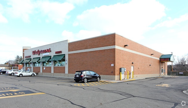
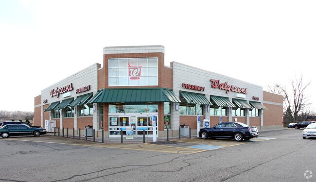
Property Detail
764 Hebron Rd
Columbus, OH
LOT 51 LEE HTS SUB + UNPLATTED LOT 1 R12 T1 Q2 (1.954 AC)
030-088686-00.000
Licking
Drugstorepharmacycvswalgreens
Ohio
B and X Area of moderate flood hazard, usually the area between the limits of the 100-year and 500-year floods.
51
2025
1.70 AC
2025
Licking County
752802
Columbus
14,509 SF
NEARBY LISTINGS FOR SALE OR LEASE
DEMOGRAPHICS near 764 Hebron Rd
1 mile
3 mile
5 mile
2025 Total Population
6,026
39,634
74,107
2030 Population
6,124
40,459
76,337
Pop Growth 2025-2030
+ 1.63%
+ 2.08%
+ 3.01%
Average Age
43
41
40
2025 Total Households
2,624
16,557
30,003
HH Growth 2025-2030
+ 1.64%
+ 2.04%
+ 2.95%
Median Household Inc
$60,713
$57,664
$60,014
Avg Household Size
2.20
2.30
2.30
2025 Avg HH Vehicles
2.00
2.00
2.00
Median Home Value
$204,702
$193,877
$219,970
Median Year Built
1967
1965
1968
Nearby Places
Map Layers
Map Styles
 Street
 Aerial
Layers
 Traffic
 Biking
Places
Listings with unknown addresses are not visible on the map
- Restaurants
- Banks
- Shops
- Fitness
- Groceries
PUBLIC TRANSPORTATION
AIRPORT
John Glenn Columbus International
Drive
Walk
Distance
John Glenn Columbus International
45 min
35.4 mi
Rickenbacker International
Drive
Walk
Distance
Rickenbacker International
49 min
37.9 mi
Nearby Properties
Address
Land Use
TOTAL SIZE
Lot Size
Zoning
Address
Land Use
TOTAL SIZE
Lot Size
Zoning
212,744 SF
19.16 AC
Address
Land Use
TOTAL SIZE
Lot Size
Zoning
54,600 SF
101.38 AC
Address
Land Use
TOTAL SIZE
Lot Size
Zoning
750,000 SF
50.61 AC
Address
Land Use
TOTAL SIZE
Lot Size
Zoning
87,785 SF
37.26 AC
Address
Land Use
TOTAL SIZE
Lot Size
Zoning
332,516 SF
44.81 AC
Address
Land Use
TOTAL SIZE
Lot Size
Zoning
2,200 SF
226.33 AC
Address
Land Use
TOTAL SIZE
Lot Size
Zoning
69,244 SF
38 AC
Address
Land Use
TOTAL SIZE
Lot Size
Zoning
67,824 SF
16.26 AC
Address
Land Use
TOTAL SIZE
Lot Size
Zoning
143,636 SF
7.25 AC
Address
Land Use
TOTAL SIZE
Lot Size
Zoning
3,108 SF
19.22 AC
Address
Land Use
TOTAL SIZE
Lot Size
Zoning
69,782 SF
2.41 AC
Address
Land Use
TOTAL SIZE
Lot Size
Zoning
223,436 SF
19.22 AC
Address
Land Use
TOTAL SIZE
Lot Size
Zoning
4,018,110 SF
19.93 AC
Address
Land Use
TOTAL SIZE
Lot Size
Zoning
172,603 SF
15.88 AC
Address
Land Use
TOTAL SIZE
Lot Size
Zoning
19,200 SF
14.56 AC
Address
Land Use
TOTAL SIZE
Lot Size
Zoning
73,269 SF
15.64 AC
Address
Land Use
TOTAL SIZE
Lot Size
Zoning
3,552 SF
5.23 AC
Address
Land Use
TOTAL SIZE
Lot Size
Zoning
31,271 SF
20.10 AC
Address
Land Use
TOTAL SIZE
Lot Size
Zoning
150,000 SF
11.18 AC
Address
Land Use
TOTAL SIZE
Lot Size
Zoning
4,080 SF
12.84 AC
Address
Land Use
TOTAL SIZE
Lot Size
Zoning
50,482 SF
13.91 AC
Address
Land Use
TOTAL SIZE
Lot Size
Zoning
33,492 SF
1.07 AC
Address
Land Use
TOTAL SIZE
Lot Size
Zoning
22,974 SF
1.64 AC
Address
Land Use
TOTAL SIZE
Lot Size
Zoning
79,454 SF
19.13 AC
Address
Land Use
TOTAL SIZE
Lot Size
Zoning
56,464 SF
16.75 AC
Address
Land Use
TOTAL SIZE
Lot Size
Zoning
63,635 SF
7.91 AC
Address
Land Use
TOTAL SIZE
Lot Size
Zoning
570,284 SF
56.17 AC
Address
Land Use
TOTAL SIZE
Lot Size
Zoning
157,644 SF
20.08 AC
Address
Land Use
TOTAL SIZE
Lot Size
Zoning
210.02 AC
Address
Land Use
TOTAL SIZE
Lot Size
Zoning
888 SF
14.60 AC
The World's #1 Commercial Real Estate Marketplace
Connect with us
© 2026 CoStar Group
The information above has been obtained from sources believed reliable. While we do not doubt its accuracy we have not verified it and make no guarantee, warranty or representation about it. It is your responsibility to independently confirm its accuracy and completeness. Any projections, opinions, assumptions, or estimates used are for example only and do not represent the current or future performance of the property. The value of this transaction to you depends on tax and other factors which should be evaluated by your tax, financial, and legal advisors. You and your advisors should conduct a careful, independent investigation of the property to determine to your satisfaction the suitability of the property for your needs.