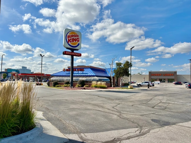
Property Record
7640 Dodge St, Omaha, NE 68114

Current Lease Availabilities
Property Detail
7640 Dodge St
Omaha, NE-IA
CROSSROADS PLAZA LOT 5 BLOCK 0 IRREG E 126.39 FT LOT 5 23525 SQ FT
1344-7521-09
Douglas
Restaurantdrivein
Nebraska
AE The base floodplain where base flood elevations are provided. AE Zones are now used on new format FIRMs instead of A1-A30 Zones.
5
2024
0.54 AC
2025
Central Omaha
006701
Omaha/Council Bluffs
3,303 SF
NEARBY LISTINGS FOR SALE OR LEASE
DEMOGRAPHICS near 7640 Dodge St
1 mile
3 mile
5 mile
2025 Total Population
9,963
108,248
307,637
2030 Population
10,245
111,056
315,814
Pop Growth 2025-2030
+ 2.83%
+ 2.59%
+ 2.66%
Average Age
39
39
38
2025 Total Households
4,499
48,248
129,502
HH Growth 2025-2030
+ 3.09%
+ 2.89%
+ 2.93%
Median Household Inc
$78,228
$70,262
$64,166
Avg Household Size
2.10
2.10
2.30
2025 Avg HH Vehicles
2.00
2.00
2.00
Median Home Value
$287,426
$249,151
$233,656
Median Year Built
1963
1962
1967
Nearby Places
Map Layers
Map Styles
 Street
 Aerial
Layers
 Traffic
 Biking
Places
Listings with unknown addresses are not visible on the map
- Restaurants
- Banks
- Shops
- Fitness
- Groceries
PUBLIC TRANSPORTATION
AIRPORT
Eppley Airfield
Drive
Walk
Distance
Eppley Airfield
23 min
9.2 mi
Nearby Properties
Address
Land Use
TOTAL SIZE
Lot Size
Zoning
Address
Land Use
TOTAL SIZE
Lot Size
Zoning
866,622 SF
20.67 AC
Address
Land Use
TOTAL SIZE
Lot Size
Zoning
255,351 SF
0.79 AC
Address
Land Use
TOTAL SIZE
Lot Size
Zoning
326,069 SF
4.88 AC
Address
Land Use
TOTAL SIZE
Lot Size
Zoning
496,976 SF
12 AC
Address
Land Use
TOTAL SIZE
Lot Size
Zoning
549,971 SF
42.84 AC
R6
Address
Land Use
TOTAL SIZE
Lot Size
Zoning
370,431 SF
8.57 AC
Address
Land Use
TOTAL SIZE
Lot Size
Zoning
702,563 SF
18.85 AC
Address
Land Use
TOTAL SIZE
Lot Size
Zoning
687,804 SF
23.14 AC
Address
Land Use
TOTAL SIZE
Lot Size
Zoning
304,034 SF
5.11 AC
R7
Address
Land Use
TOTAL SIZE
Lot Size
Zoning
387,860 SF
7.20 AC
Address
Land Use
TOTAL SIZE
Lot Size
Zoning
398,593 SF
10.80 AC
Address
Land Use
TOTAL SIZE
Lot Size
Zoning
282,688 SF
18.71 AC
Address
Land Use
TOTAL SIZE
Lot Size
Zoning
389,488 SF
4.30 AC
Address
Land Use
TOTAL SIZE
Lot Size
Zoning
145,190 SF
5.45 AC
Address
Land Use
TOTAL SIZE
Lot Size
Zoning
130,286 SF
4.31 AC
GO
Address
Land Use
TOTAL SIZE
Lot Size
Zoning
96,871 SF
9.98 AC
Address
Land Use
TOTAL SIZE
Lot Size
Zoning
256,558 SF
7 AC
GI
Address
Land Use
TOTAL SIZE
Lot Size
Zoning
238,954 SF
14.65 AC
Address
Land Use
TOTAL SIZE
Lot Size
Zoning
120,078 SF
1.24 AC
MU
Address
Land Use
TOTAL SIZE
Lot Size
Zoning
329,515 SF
6.37 AC
Address
Land Use
TOTAL SIZE
Lot Size
Zoning
114,936 SF
1.93 AC
Address
Land Use
TOTAL SIZE
Lot Size
Zoning
405,820 SF
2.10 AC
Address
Land Use
TOTAL SIZE
Lot Size
Zoning
129,910 SF
0.92 AC
Address
Land Use
TOTAL SIZE
Lot Size
Zoning
646,213 SF
37.22 AC
Address
Land Use
TOTAL SIZE
Lot Size
Zoning
354,615 SF
18.13 AC
R6
Address
Land Use
TOTAL SIZE
Lot Size
Zoning
234,332 SF
12.30 AC
Address
Land Use
TOTAL SIZE
Lot Size
Zoning
112,933 SF
1.23 AC
MU
Address
Land Use
TOTAL SIZE
Lot Size
Zoning
255,205 SF
9.41 AC
R6
Address
Land Use
TOTAL SIZE
Lot Size
Zoning
249,902 SF
13.02 AC
CC
Address
Land Use
TOTAL SIZE
Lot Size
Zoning
248,169 SF
10.39 AC
The World's #1 Commercial Real Estate Marketplace
Connect with us
© 2026 CoStar Group
The information above has been obtained from sources believed reliable. While we do not doubt its accuracy we have not verified it and make no guarantee, warranty or representation about it. It is your responsibility to independently confirm its accuracy and completeness. Any projections, opinions, assumptions, or estimates used are for example only and do not represent the current or future performance of the property. The value of this transaction to you depends on tax and other factors which should be evaluated by your tax, financial, and legal advisors. You and your advisors should conduct a careful, independent investigation of the property to determine to your satisfaction the suitability of the property for your needs.