Property Record
7642 20Th Ave, Jenison, MI 49428
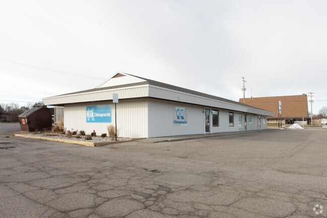

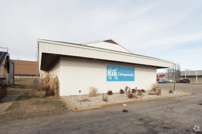
Property Detail
7642 20Th Ave
70-14-15-200-008
PART W 1/2 OF SW 1/4 OF NE 1/4 COM 465 FT W & 213 FT N OF SE COR, TH N 117 FT, W TO N&S 1/4 LI, TH S 117 FT, TH E TO BEG SEC
Medicalbuilding
OTTAWA
NS
Michigan
B and X Area of moderate flood hazard, usually the area between the limits of the 100-year and 500-year floods.
0.44 AC
2025
E Ottawa Cnty/Hudsonville
2025
West Michigan
021606
Grand Rapids-Wyoming-Kentwood, MI
3,072 SF
NEARBY LISTINGS FOR SALE OR LEASE
DEMOGRAPHICS near 7642 20Th Ave
1 mile
3 mile
5 mile
2025 Total Population
10,256
48,200
100,922
2030 Population
10,443
49,507
103,974
Pop Growth 2025-2030
+ 1.82%
+ 2.71%
+ 3.02%
Average Age
40
39
38
2025 Total Households
3,670
17,218
35,492
HH Growth 2025-2030
+ 1.99%
+ 2.80%
+ 3.20%
Median Household Inc
$94,843
$95,084
$91,493
Avg Household Size
2.70
2.70
2.70
2025 Avg HH Vehicles
2.00
2.00
2.00
Median Home Value
$276,117
$319,767
$328,193
Median Year Built
1972
1983
1986
Nearby Places
Map Layers
Map Styles
 Street
 Aerial
Layers
 Traffic
 Biking
Places
Listings with unknown addresses are not visible on the map
- Restaurants
- Banks
- Shops
- Fitness
- Groceries
PUBLIC TRANSPORTATION
COMMUTER RAIL
Drive
Walk
Distance
16 min
9.6 mi
AIRPORT
Gerald R Ford International
Drive
Walk
Distance
Gerald R Ford International
34 min
18.4 mi
Nearby Properties
Address
Land Use
TOTAL SIZE
Lot Size
Zoning
Address
Land Use
TOTAL SIZE
Lot Size
Zoning
268,440 SF
28.11 AC
HDR
Address
Land Use
TOTAL SIZE
Lot Size
Zoning
20.61 AC
HDR
Address
Land Use
TOTAL SIZE
Lot Size
Zoning
173,288 SF
4.17 AC
PUD
Address
Land Use
TOTAL SIZE
Lot Size
Zoning
114,312 SF
22.23 AC
R-4
Address
Land Use
TOTAL SIZE
Lot Size
Zoning
222,785 SF
26.69 AC
CS
Address
Land Use
TOTAL SIZE
Lot Size
Zoning
124,950 SF
18.30 AC
MHR
Address
Land Use
TOTAL SIZE
Lot Size
Zoning
66,766 SF
R-1-A
Address
Land Use
TOTAL SIZE
Lot Size
Zoning
139,774 SF
10.67 AC
HDR-B
Address
Land Use
TOTAL SIZE
Lot Size
Zoning
82,554 SF
5.56 AC
HDR
Address
Land Use
TOTAL SIZE
Lot Size
Zoning
6.77 AC
R3-B
Address
Land Use
TOTAL SIZE
Lot Size
Zoning
71,102 SF
8.65 AC
MHR
Address
Land Use
TOTAL SIZE
Lot Size
Zoning
45,636 SF
14.11 AC
C-5
Address
Land Use
TOTAL SIZE
Lot Size
Zoning
106,193 SF
10.68 AC
CS
Address
Land Use
TOTAL SIZE
Lot Size
Zoning
8,448 SF
2.68 AC
R-4
Address
Land Use
TOTAL SIZE
Lot Size
Zoning
59,018 SF
10.60 AC
HDR
Address
Land Use
TOTAL SIZE
Lot Size
Zoning
66,980 SF
LDR
Address
Land Use
TOTAL SIZE
Lot Size
Zoning
44,400 SF
6.69 AC
HS
Address
Land Use
TOTAL SIZE
Lot Size
Zoning
16,816 SF
3.33 AC
NS
Address
Land Use
TOTAL SIZE
Lot Size
Zoning
90,900 SF
8.53 AC
CS
Address
Land Use
TOTAL SIZE
Lot Size
Zoning
94,894 SF
7.35 AC
I
Address
Land Use
TOTAL SIZE
Lot Size
Zoning
5,054 SF
3.86 AC
LDR
Address
Land Use
TOTAL SIZE
Lot Size
Zoning
39,306 SF
3.65 AC
I
Address
Land Use
TOTAL SIZE
Lot Size
Zoning
47,632 SF
4 AC
CS
Address
Land Use
TOTAL SIZE
Lot Size
Zoning
Address
Land Use
TOTAL SIZE
Lot Size
Zoning
33,530 SF
3.84 AC
HDR
Address
Land Use
TOTAL SIZE
Lot Size
Zoning
10,000 SF
2.02 AC
OS
Address
Land Use
TOTAL SIZE
Lot Size
Zoning
38,588 SF
3.14 AC
CS
Address
Land Use
TOTAL SIZE
Lot Size
Zoning
52,856 SF
3.94 AC
I
Address
Land Use
TOTAL SIZE
Lot Size
Zoning
30,784 SF
4.75 AC
MHR
Address
Land Use
TOTAL SIZE
Lot Size
Zoning
19,320 SF
2.90 AC
CS
The World's #1 Commercial Real Estate Marketplace
Connect with us
© 2026 CoStar Group
The information above has been obtained from sources believed reliable. While we do not doubt its accuracy we have not verified it and make no guarantee, warranty or representation about it. It is your responsibility to independently confirm its accuracy and completeness. Any projections, opinions, assumptions, or estimates used are for example only and do not represent the current or future performance of the property. The value of this transaction to you depends on tax and other factors which should be evaluated by your tax, financial, and legal advisors. You and your advisors should conduct a careful, independent investigation of the property to determine to your satisfaction the suitability of the property for your needs.