Property Record
7643 Roanoke Rd, Shawsville, VA 24162
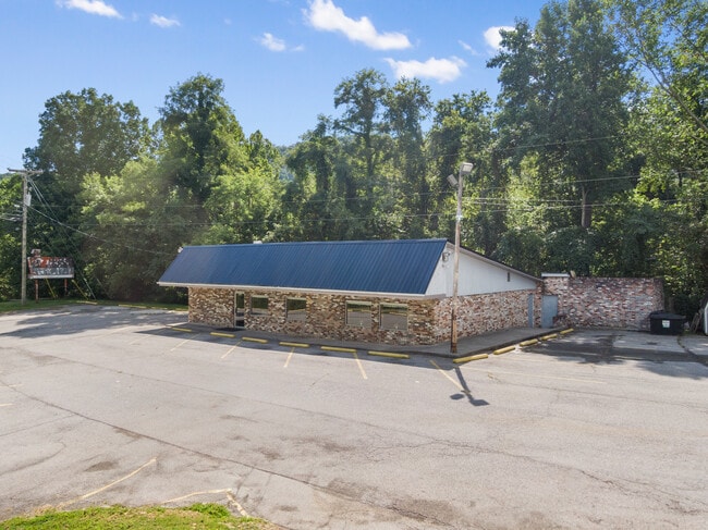


This Property Is For Sale
NEARBY LISTINGS FOR SALE OR LEASE
-
-
View all Shawsville listings for sale on LoopNet.com
Property Detail
7643 Roanoke Rd
007760
SHAWSVILLE RT 11 NR TELEPHONE BLDG
Commercialnec
Montgomery
X
Virginia
51121C0190C
0.63 AC
2025
Blacksburg & Wytheville
2025
Other Market Areas
021400
Blacksburg-Christiansburg-Radford, VA
2,980 SF
DEMOGRAPHICS near 7643 Roanoke Rd
1 Mile
3 Mile
5 Mile
2024 Total Population
977
2,317
5,534
2029 Population
987
2,334
5,575
Pop Growth 2024-2029
+ 1.02%
+ 0.73%
+ 0.74%
Average Age
43
43
43
2024 Total Households
397
943
2,213
HH Growth 2024-2029
+ 1.01%
+ 0.74%
+ 0.77%
Median Household Inc
$57,036
$59,253
$59,285
Avg Household Size
2.40
2.40
2.40
2024 Avg HH Vehicles
2.00
2.00
2.00
Median Home Value
$108,730
$133,988
$170,414
Median Year Built
1980
1979
1979
Nearby Places
Map Layers
Map Styles
 Street
 Aerial
- Restaurants
- Banks
- Shops
- Fitness
- Groceries
PUBLIC TRANSPORTATION
AIRPORT
Roanoke/Blacksburg Regional (Woodrum Field)
DRIVE
WALK
Distance
Roanoke/Blacksburg Regional (Woodrum Field)
35 min
23.9 mi
Freight Ports
Virginia Port Authority - Richmond
DRIVE
WALK
Distance
Virginia Port Authority - Richmond
237 min
207.7 mi
Nearby Properties
Address
Land Use
TOTAL SIZE
Lot Size
Zoning
Address
Land Use
TOTAL SIZE
Lot Size
Zoning
107,055 SF
34.45 AC
A1
Address
Land Use
TOTAL SIZE
Lot Size
Zoning
98,713 SF
0.02 AC
A1
Address
Land Use
TOTAL SIZE
Lot Size
Zoning
8,369 SF
330.14 AC
A1
Address
Land Use
TOTAL SIZE
Lot Size
Zoning
70,000 SF
1.80 AC
A1
Address
Land Use
TOTAL SIZE
Lot Size
Zoning
37,206 SF
1.80 AC
GB
Address
Land Use
TOTAL SIZE
Lot Size
Zoning
3,112 SF
510.65 AC
A1
Address
Land Use
TOTAL SIZE
Lot Size
Zoning
95.79 AC
A1
Address
Land Use
TOTAL SIZE
Lot Size
Zoning
3,756 SF
248.52 AC
A1
Address
Land Use
TOTAL SIZE
Lot Size
Zoning
12,038 SF
1.79 AC
RM1
Address
Land Use
TOTAL SIZE
Lot Size
Zoning
5,777 SF
188.10 AC
A1
Address
Land Use
TOTAL SIZE
Lot Size
Zoning
9,100 SF
0.95 AC
GB
Address
Land Use
TOTAL SIZE
Lot Size
Zoning
14.37 AC
A1
Address
Land Use
TOTAL SIZE
Lot Size
Zoning
1,500 SF
9.84 AC
M1
Address
Land Use
TOTAL SIZE
Lot Size
Zoning
101.46 AC
A1
Address
Land Use
TOTAL SIZE
Lot Size
Zoning
3,938 SF
3.83 AC
A1
Address
Land Use
TOTAL SIZE
Lot Size
Zoning
10,545 SF
2.41 AC
A1
Address
Land Use
TOTAL SIZE
Lot Size
Zoning
1.76 AC
A1
Address
Land Use
TOTAL SIZE
Lot Size
Zoning
316.49 AC
A1
Address
Land Use
TOTAL SIZE
Lot Size
Zoning
2.66 AC
A1
Address
Land Use
TOTAL SIZE
Lot Size
Zoning
2,688 SF
0.83 AC
GB
Address
Land Use
TOTAL SIZE
Lot Size
Zoning
711.49 AC
A1
Address
Land Use
TOTAL SIZE
Lot Size
Zoning
2,925 SF
29.51 AC
A1
Address
Land Use
TOTAL SIZE
Lot Size
Zoning
4,512 SF
0.31 AC
GB
Address
Land Use
TOTAL SIZE
Lot Size
Zoning
9,856 SF
7 AC
A1
Address
Land Use
TOTAL SIZE
Lot Size
Zoning
3,328 SF
60.70 AC
A1
Address
Land Use
TOTAL SIZE
Lot Size
Zoning
3,248 SF
483 AC
A1
Address
Land Use
TOTAL SIZE
Lot Size
Zoning
0.01 AC
A1
Address
Land Use
TOTAL SIZE
Lot Size
Zoning
3,033 SF
77.44 AC
A1
Address
Land Use
TOTAL SIZE
Lot Size
Zoning
2.24 AC
R3
Address
Land Use
TOTAL SIZE
Lot Size
Zoning
3,421 SF
0.43 AC
GB
The World's #1 Commercial Real Estate Marketplace
Connect with us
© 2026 CoStar Group
The information above has been obtained from sources believed reliable. While we do not doubt its accuracy we have not verified it and make no guarantee, warranty or representation about it. It is your responsibility to independently confirm its accuracy and completeness. Any projections, opinions, assumptions, or estimates used are for example only and do not represent the current or future performance of the property. The value of this transaction to you depends on tax and other factors which should be evaluated by your tax, financial, and legal advisors. You and your advisors should conduct a careful, independent investigation of the property to determine to your satisfaction the suitability of the property for your needs.