Property Record
350 W North St, Greenfield, IN 46140
This Property Is For Sale
NEARBY LISTINGS FOR SALE OR LEASE
Property Detail
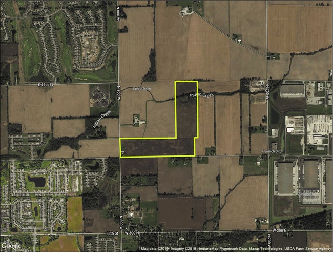
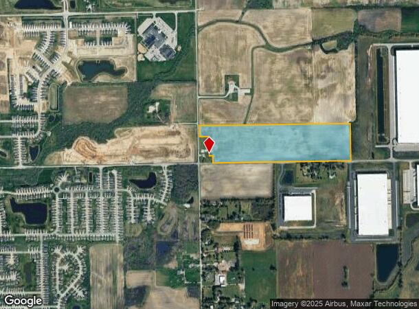
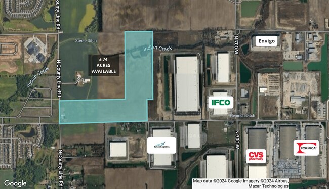
350 W North St
30-05-14-200-010.000-006
S NW 14-16-5 38AC
Agriculturalland
Hancock
X
Indiana
18097C0180F
38 AC
2024
Hancock County
2024
Indianapolis
410402
Indianapolis-Carmel-Anderson, IN
DEMOGRAPHICS near 350 W North St
1 Mile
3 Mile
5 Mile
2024 Total Population
1,957
41,440
118,557
2029 Population
1,962
41,547
118,780
Pop Growth 2024-2029
+ 0.26%
+ 0.26%
+ 0.19%
Average Age
34
35
36
2024 Total Households
628
14,903
44,340
HH Growth 2024-2029
+ 0.32%
+ 0.21%
+ 0.20%
Median Household Inc
$78,983
$61,515
$61,513
Avg Household Size
3.00
2.70
2.60
2024 Avg HH Vehicles
2.00
2.00
2.00
Median Home Value
$185,018
$158,092
$171,413
Median Year Built
2004
1993
1984
Nearby Places
- Restaurants
- Banks
- Shops
- Fitness
- Groceries
PUBLIC TRANSPORTATION
AIRPORT
Indianapolis International
DRIVE
WALK
Distance
Indianapolis International
48 min
28.5 mi
Freight Ports
Port of Toledo
DRIVE
WALK
Distance
Port of Toledo
260 min
213.8 mi
Nearby Properties
Address
Land Use
TOTAL SIZE
Lot Size
Zoning
Address
Land Use
TOTAL SIZE
Lot Size
Zoning
2,896,370 SF
54.48 AC
Address
Land Use
TOTAL SIZE
Lot Size
Zoning
77.34 AC
Address
Land Use
TOTAL SIZE
Lot Size
Zoning
67.17 AC
Address
Land Use
TOTAL SIZE
Lot Size
Zoning
51.66 AC
Address
Land Use
TOTAL SIZE
Lot Size
Zoning
986,112 SF
41.42 AC
Address
Land Use
TOTAL SIZE
Lot Size
Zoning
13.89 AC
Address
Land Use
TOTAL SIZE
Lot Size
Zoning
1,720 SF
63.09 AC
Address
Land Use
TOTAL SIZE
Lot Size
Zoning
57.77 AC
Address
Land Use
TOTAL SIZE
Lot Size
Zoning
2,056 SF
76.90 AC
Address
Land Use
TOTAL SIZE
Lot Size
Zoning
2,398 SF
64.58 AC
Address
Land Use
TOTAL SIZE
Lot Size
Zoning
67.09 AC
Address
Land Use
TOTAL SIZE
Lot Size
Zoning
416,714 SF
47.60 AC
Address
Land Use
TOTAL SIZE
Lot Size
Zoning
540,000 SF
33.78 AC
Address
Land Use
TOTAL SIZE
Lot Size
Zoning
630,000 SF
30.03 AC
Address
Land Use
TOTAL SIZE
Lot Size
Zoning
2,620 SF
32.36 AC
Address
Land Use
TOTAL SIZE
Lot Size
Zoning
390,106 SF
25.24 AC
Address
Land Use
TOTAL SIZE
Lot Size
Zoning
532,932 SF
61.88 AC
ZO03
Address
Land Use
TOTAL SIZE
Lot Size
Zoning
28.71 AC
Address
Land Use
TOTAL SIZE
Lot Size
Zoning
2,556 SF
35.56 AC
ZO01
Address
Land Use
TOTAL SIZE
Lot Size
Zoning
80,956 SF
9.91 AC
Address
Land Use
TOTAL SIZE
Lot Size
Zoning
439,040 SF
31.70 AC
Address
Land Use
TOTAL SIZE
Lot Size
Zoning
455,424 SF
33.96 AC
Address
Land Use
TOTAL SIZE
Lot Size
Zoning
129,608 SF
54.85 AC
ZO01
Address
Land Use
TOTAL SIZE
Lot Size
Zoning
200,806 SF
26.29 AC
Address
Land Use
TOTAL SIZE
Lot Size
Zoning
423,000 SF
30.62 AC
Address
Land Use
TOTAL SIZE
Lot Size
Zoning
2,232 SF
22.88 AC
Address
Land Use
TOTAL SIZE
Lot Size
Zoning
679,214 SF
16.70 AC
ZO01
Address
Land Use
TOTAL SIZE
Lot Size
Zoning
259,780 SF
20.36 AC
Address
Land Use
TOTAL SIZE
Lot Size
Zoning
368,075 SF
25.49 AC
Address
Land Use
TOTAL SIZE
Lot Size
Zoning
35.60 AC
The World's #1 Commercial Real Estate Marketplace
Connect with us
© 2025 CoStar Group
The information above has been obtained from sources believed reliable. While we do not doubt its accuracy we have not verified it and make no guarantee, warranty or representation about it. It is your responsibility to independently confirm its accuracy and completeness. Any projections, opinions, assumptions, or estimates used are for example only and do not represent the current or future performance of the property. The value of this transaction to you depends on tax and other factors which should be evaluated by your tax, financial, and legal advisors. You and your advisors should conduct a careful, independent investigation of the property to determine to your satisfaction the suitability of the property for your needs.