No Photo
Property Record
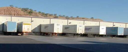
765 N Target Range Rd, Nogales, AZ 85621

Property Detail
765 N Target Range Rd
113-49-028B
A PORTION OF LAND IN THE NE4 OF SECTION 13 T24S R13E LYING BETWEE N HWY 189 AND TARGET RANGE ROAD
Warehouse
Santa Cruz
B and X Area of moderate flood hazard, usually the area between the limits of the 100-year and 500-year floods.
Arizona
2024
10.89 AC
2025
Arizona SE & Sierra Vista Area
966401
Other Market Areas
159,143 SF
Nogales, AZ
NEARBY LISTINGS FOR SALE OR LEASE
-
-
-
No Photo
1294 Calle Doctor Francisco ArreolaHeroica Nogales, SON 84060
Negotiable
1,991 - 10,000 SF
Industrial
-
View all Nogales listings for lease on LoopNet.com
DEMOGRAPHICS near 765 N Target Range Rd
1 mile
3 mile
5 mile
2025 Total Population
1,220
17,418
23,678
2030 Population
1,312
18,729
25,444
Pop Growth 2025-2030
+ 7.54%
+ 7.53%
+ 7.46%
Average Age
39
39
40
2025 Total Households
425
6,215
8,302
HH Growth 2025-2030
+ 7.76%
+ 7.61%
+ 7.58%
Median Household Inc
$43,096
$37,866
$40,841
Avg Household Size
2.80
2.80
2.80
2025 Avg HH Vehicles
2.00
2.00
2.00
Median Home Value
$135,815
$166,786
$183,997
Median Year Built
1975
1976
1977
Nearby Places
Map Layers
Map Styles
 Street
 Aerial
Transit
 Traffic
 Biking
Places
Listings with unknown addresses are not visible on the map
- Restaurants
- Banks
- Shops
- Fitness
- Groceries
SALE & LEASE HISTORY
LISTING DATE
SALE/LEASE

Sep 25, 2016
For Lease
Nearby Properties
Address
Land Use
TOTAL SIZE
Lot Size
Zoning
Address
Land Use
TOTAL SIZE
Lot Size
Zoning
0.21 AC
Address
Land Use
TOTAL SIZE
Lot Size
Zoning
38,328 SF
94.80 AC
Address
Land Use
TOTAL SIZE
Lot Size
Zoning
27,835 SF
10.55 AC
Address
Land Use
TOTAL SIZE
Lot Size
Zoning
149,179 SF
64.65 AC
Address
Land Use
TOTAL SIZE
Lot Size
Zoning
55,140 SF
8.54 AC
Address
Land Use
TOTAL SIZE
Lot Size
Zoning
183,703 SF
17.11 AC
Address
Land Use
TOTAL SIZE
Lot Size
Zoning
414,855 SF
23.51 AC
Address
Land Use
TOTAL SIZE
Lot Size
Zoning
57,457 SF
8.86 AC
Address
Land Use
TOTAL SIZE
Lot Size
Zoning
2,565 SF
23.36 AC
Address
Land Use
TOTAL SIZE
Lot Size
Zoning
89,356 SF
6.16 AC
Address
Land Use
TOTAL SIZE
Lot Size
Zoning
79,160 SF
11.47 AC
Address
Land Use
TOTAL SIZE
Lot Size
Zoning
98,007 SF
16.52 AC
Address
Land Use
TOTAL SIZE
Lot Size
Zoning
21,666 SF
7.76 AC
Address
Land Use
TOTAL SIZE
Lot Size
Zoning
46,683 SF
20.31 AC
Address
Land Use
TOTAL SIZE
Lot Size
Zoning
3,822 SF
2.87 AC
Address
Land Use
TOTAL SIZE
Lot Size
Zoning
119,309 SF
9.70 AC
Address
Land Use
TOTAL SIZE
Lot Size
Zoning
116,163 SF
5.07 AC
Address
Land Use
TOTAL SIZE
Lot Size
Zoning
203,600 SF
11.35 AC
Address
Land Use
TOTAL SIZE
Lot Size
Zoning
Address
Land Use
TOTAL SIZE
Lot Size
Zoning
188,992 SF
7.27 AC
Address
Land Use
TOTAL SIZE
Lot Size
Zoning
8,602 SF
14.42 AC
Address
Land Use
TOTAL SIZE
Lot Size
Zoning
14,502 SF
9.14 AC
Address
Land Use
TOTAL SIZE
Lot Size
Zoning
214,045 SF
7.67 AC
Address
Land Use
TOTAL SIZE
Lot Size
Zoning
141,279 SF
2.82 AC
Address
Land Use
TOTAL SIZE
Lot Size
Zoning
51,049 SF
2.25 AC
Address
Land Use
TOTAL SIZE
Lot Size
Zoning
111,544 SF
92.88 AC
Address
Land Use
TOTAL SIZE
Lot Size
Zoning
17,026 SF
6 AC
Address
Land Use
TOTAL SIZE
Lot Size
Zoning
46,686 SF
5 AC
Address
Land Use
TOTAL SIZE
Lot Size
Zoning
107,065 SF
4.40 AC
The World's #1 Commercial Real Estate Marketplace
Connect with us
© 2026 CoStar Group
The information above has been obtained from sources believed reliable. While we do not doubt its accuracy we have not verified it and make no guarantee, warranty or representation about it. It is your responsibility to independently confirm its accuracy and completeness. Any projections, opinions, assumptions, or estimates used are for example only and do not represent the current or future performance of the property. The value of this transaction to you depends on tax and other factors which should be evaluated by your tax, financial, and legal advisors. You and your advisors should conduct a careful, independent investigation of the property to determine to your satisfaction the suitability of the property for your needs.