Property Record
765 Nantasket Ave, Hull, MA 02045

NEARBY LISTINGS FOR SALE OR LEASE
-
-
View all Hull listings for sale on LoopNet.com
Property Detail
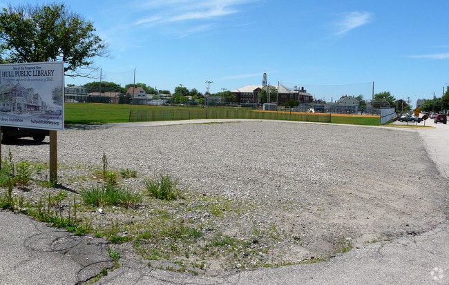
765 Nantasket Ave
Governmentalpublicusegeneral
Plymouth
AE
Massachusetts
25023C0017J
6.05 AC
0
Route 3 Corridor
2025
Boston
500104
Boston-Cambridge-Newton, MA-NH
944 SF
HULL-000015-000000-000142
DEMOGRAPHICS near 765 Nantasket Ave
1 Mile
3 Mile
5 Mile
2024 Total Population
4,519
11,649
36,969
2029 Population
4,670
11,950
37,679
Pop Growth 2024-2029
+ 3.34%
+ 2.58%
+ 1.92%
Average Age
48
48
45
2024 Total Households
1,967
5,263
15,598
HH Growth 2024-2029
+ 3.25%
+ 2.57%
+ 2.15%
Median Household Inc
$120,613
$125,091
$127,211
Avg Household Size
2.20
2.20
2.30
2024 Avg HH Vehicles
2.00
2.00
2.00
Median Home Value
$602,345
$626,902
$708,842
Median Year Built
1948
1949
1958
Nearby Places
Map Layers
Map Styles
 Street
 Aerial
- Restaurants
- Banks
- Shops
- Fitness
- Groceries
PUBLIC TRANSPORTATION
COMMUTER RAIL
Nantasket Junction (Greenbush Line - Massachusetts Bay Transportation Authority Commuter Rail (Purple Line))
DRIVE
WALK
Distance
Nantasket Junction (Greenbush Line - Massachusetts Bay Transportation Authority Commuter Rail (Purple Line))
10 min
4.7 mi
Cohasset (Greenbush Line - Massachusetts Bay Transportation Authority Commuter Rail (Purple Line))
DRIVE
WALK
Distance
Cohasset (Greenbush Line - Massachusetts Bay Transportation Authority Commuter Rail (Purple Line))
12 min
6.3 mi
AIRPORT
General Edward Lawrence Logan International
DRIVE
WALK
Distance
General Edward Lawrence Logan International
43 min
22.7 mi
Freight Ports
Port of Boston
DRIVE
WALK
Distance
Port of Boston
40 min
20.5 mi
Nearby Properties
Address
Land Use
TOTAL SIZE
Lot Size
Zoning
Address
Land Use
TOTAL SIZE
Lot Size
Zoning
106,581 SF
8.40 AC
POS
Address
Land Use
TOTAL SIZE
Lot Size
Zoning
149,190 SF
10.04 AC
POS
Address
Land Use
TOTAL SIZE
Lot Size
Zoning
79,203 SF
1.24 AC
BUS
Address
Land Use
TOTAL SIZE
Lot Size
Zoning
61,014 SF
1.25 AC
POS
Address
Land Use
TOTAL SIZE
Lot Size
Zoning
12.64 AC
POS
Address
Land Use
TOTAL SIZE
Lot Size
Zoning
18.42 AC
POS
Address
Land Use
TOTAL SIZE
Lot Size
Zoning
11,301 SF
6.17 AC
POS
Address
Land Use
TOTAL SIZE
Lot Size
Zoning
12,950 SF
0.55 AC
CRB
Address
Land Use
TOTAL SIZE
Lot Size
Zoning
132 SF
255.50 AC
Address
Land Use
TOTAL SIZE
Lot Size
Zoning
50,775 SF
1.12 AC
BUS
Address
Land Use
TOTAL SIZE
Lot Size
Zoning
25,804 SF
2.07 AC
MFA
Address
Land Use
TOTAL SIZE
Lot Size
Zoning
7,452 SF
4.25 AC
SFB
Address
Land Use
TOTAL SIZE
Lot Size
Zoning
20.31 AC
Address
Land Use
TOTAL SIZE
Lot Size
Zoning
30,946 SF
0.80 AC
BUS
Address
Land Use
TOTAL SIZE
Lot Size
Zoning
2,000 SF
3.43 AC
CRC
Address
Land Use
TOTAL SIZE
Lot Size
Zoning
7,500 SF
3.09 AC
WAT
Address
Land Use
TOTAL SIZE
Lot Size
Zoning
8,566 SF
0.48 AC
Address
Land Use
TOTAL SIZE
Lot Size
Zoning
5.04 AC
CRA
Address
Land Use
TOTAL SIZE
Lot Size
Zoning
2.85 AC
CON
Address
Land Use
TOTAL SIZE
Lot Size
Zoning
28 AC
E
Address
Land Use
TOTAL SIZE
Lot Size
Zoning
3.15 AC
POS
Address
Land Use
TOTAL SIZE
Lot Size
Zoning
4.42 AC
CRA
Address
Land Use
TOTAL SIZE
Lot Size
Zoning
10,518 SF
0.64 AC
SFA
Address
Land Use
TOTAL SIZE
Lot Size
Zoning
1.54 AC
MFB
Address
Land Use
TOTAL SIZE
Lot Size
Zoning
17,568 SF
1.48 AC
POS
Address
Land Use
TOTAL SIZE
Lot Size
Zoning
12,696 SF
3.56 AC
POS
Address
Land Use
TOTAL SIZE
Lot Size
Zoning
4.04 AC
Address
Land Use
TOTAL SIZE
Lot Size
Zoning
16 AC
SFB
Address
Land Use
TOTAL SIZE
Lot Size
Zoning
5,354 SF
0.13 AC
SFA
The World's #1 Commercial Real Estate Marketplace
Connect with us
© 2025 CoStar Group
The information above has been obtained from sources believed reliable. While we do not doubt its accuracy we have not verified it and make no guarantee, warranty or representation about it. It is your responsibility to independently confirm its accuracy and completeness. Any projections, opinions, assumptions, or estimates used are for example only and do not represent the current or future performance of the property. The value of this transaction to you depends on tax and other factors which should be evaluated by your tax, financial, and legal advisors. You and your advisors should conduct a careful, independent investigation of the property to determine to your satisfaction the suitability of the property for your needs.