Property Record
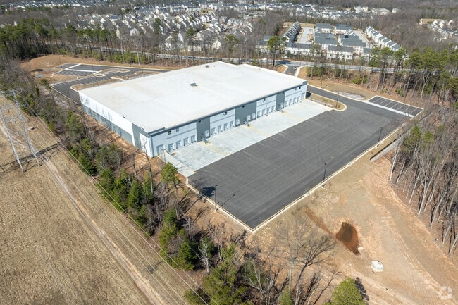
7653 Solley Rd, Glen Burnie, MD 21060


This Property Is For Sale
Current Lease Availabilities
NEARBY LISTINGS FOR SALE OR LEASE
Property Detail
7653 Solley Rd
Baltimore-Columbia-Towson, MD
Chesapeakes Brandon Woo
03-000-90251946
LOT 4 CHESAPEAKES BRANDON WOO
Warehouse
Anne Arundel
X
Maryland
24003C0066F
4
2024
15.82 AC
2025
Route 2 Corridor
751103
Baltimore
80,150 SF
DEMOGRAPHICS near 7653 Solley Rd
1 Mile
3 Mile
5 Mile
2024 Total Population
7,620
67,925
165,509
2029 Population
7,813
69,545
168,994
Pop Growth 2024-2029
+ 2.53%
+ 2.38%
+ 2.11%
Average Age
33
39
39
2024 Total Households
2,866
25,315
61,779
HH Growth 2024-2029
+ 2.58%
+ 2.45%
+ 2.14%
Median Household Inc
$114,251
$100,329
$90,629
Avg Household Size
2.70
2.60
2.60
2024 Avg HH Vehicles
2.00
2.00
2.00
Median Home Value
$381,625
$345,928
$333,327
Median Year Built
2011
1982
1976
Nearby Places
Map Layers
Map Styles
 Street
 Aerial
- Restaurants
- Banks
- Shops
- Fitness
- Groceries
PUBLIC TRANSPORTATION
AIRPORT
Baltimore/Washington International Thurgood Marshall
DRIVE
WALK
Distance
Baltimore/Washington International Thurgood Marshall
22 min
13.5 mi
Freight Ports
Port of Baltimore
DRIVE
WALK
Distance
Port of Baltimore
24 min
11.6 mi
Nearby Properties
Address
Land Use
TOTAL SIZE
Lot Size
Zoning
Address
Land Use
TOTAL SIZE
Lot Size
Zoning
1,186,080 SF
456.52 AC
W3
Address
Land Use
TOTAL SIZE
Lot Size
Zoning
467.03 AC
W2
Address
Land Use
TOTAL SIZE
Lot Size
Zoning
374,664 SF
22.89 AC
R15
Address
Land Use
TOTAL SIZE
Lot Size
Zoning
32.18 AC
R15
Address
Land Use
TOTAL SIZE
Lot Size
Zoning
176,405 SF
41.81 AC
C3
Address
Land Use
TOTAL SIZE
Lot Size
Zoning
512,900 SF
51.15 AC
W1
Address
Land Use
TOTAL SIZE
Lot Size
Zoning
252,911 SF
8.32 AC
R10
Address
Land Use
TOTAL SIZE
Lot Size
Zoning
111.20 AC
W3
Address
Land Use
TOTAL SIZE
Lot Size
Zoning
16.72 AC
R15
Address
Land Use
TOTAL SIZE
Lot Size
Zoning
7.07 AC
R15
Address
Land Use
TOTAL SIZE
Lot Size
Zoning
340,000 SF
35 AC
W1
Address
Land Use
TOTAL SIZE
Lot Size
Zoning
238,688 SF
35 AC
R5
Address
Land Use
TOTAL SIZE
Lot Size
Zoning
291,600 SF
14.52 AC
W2
Address
Land Use
TOTAL SIZE
Lot Size
Zoning
304,404 SF
16.74 AC
W3
Address
Land Use
TOTAL SIZE
Lot Size
Zoning
119,220 SF
6.99 AC
W1
Address
Land Use
TOTAL SIZE
Lot Size
Zoning
345,088 SF
28.26 AC
W2
Address
Land Use
TOTAL SIZE
Lot Size
Zoning
351,620 SF
15.68 AC
W2
Address
Land Use
TOTAL SIZE
Lot Size
Zoning
8.78 AC
R15
Address
Land Use
TOTAL SIZE
Lot Size
Zoning
28,188 SF
6.51 AC
C3
Address
Land Use
TOTAL SIZE
Lot Size
Zoning
674,828 SF
167.04 AC
W3
Address
Land Use
TOTAL SIZE
Lot Size
Zoning
344,254 SF
20.82 AC
W3
Address
Land Use
TOTAL SIZE
Lot Size
Zoning
122,175 SF
7.32 AC
R5
Address
Land Use
TOTAL SIZE
Lot Size
Zoning
191,856 SF
5.61 AC
R15
Address
Land Use
TOTAL SIZE
Lot Size
Zoning
141,829 SF
29.38 AC
R5
Address
Land Use
TOTAL SIZE
Lot Size
Zoning
336,216 SF
19.99 AC
W1
Address
Land Use
TOTAL SIZE
Lot Size
Zoning
154,368 SF
17.01 AC
W3
Address
Land Use
TOTAL SIZE
Lot Size
Zoning
9.97 AC
R15
Address
Land Use
TOTAL SIZE
Lot Size
Zoning
45,570 SF
3.46 AC
C4
Address
Land Use
TOTAL SIZE
Lot Size
Zoning
371,145 SF
17.41 AC
W1
Address
Land Use
TOTAL SIZE
Lot Size
Zoning
185,787 SF
12.60 AC
W3
The World's #1 Commercial Real Estate Marketplace
Connect with us
© 2026 CoStar Group
The information above has been obtained from sources believed reliable. While we do not doubt its accuracy we have not verified it and make no guarantee, warranty or representation about it. It is your responsibility to independently confirm its accuracy and completeness. Any projections, opinions, assumptions, or estimates used are for example only and do not represent the current or future performance of the property. The value of this transaction to you depends on tax and other factors which should be evaluated by your tax, financial, and legal advisors. You and your advisors should conduct a careful, independent investigation of the property to determine to your satisfaction the suitability of the property for your needs.