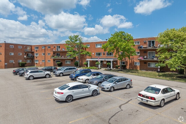
Property Record
7656 Broadview Rd, Cleveland, OH 44134

Save to a Folder
{{folder.Name}}
{{folder.ListingIds.length}} Properties
{{folder.ListingIds.length}} Property
Create a New Folder
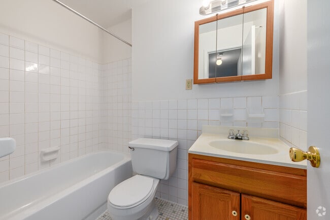
Property Detail
7656 Broadview Rd
453-20-020
30 & 45 SP 1491.29FT S CL PL VLY 314.69FT IN REAR
Apartment
Cuyahoga
MF-1
Ohio
B and X Area of moderate flood hazard, usually the area between the limits of the 100-year and 500-year floods.
30
2025
8.95 AC
2025
Parma
177505
Cleveland
96,600 SF
Cleveland-Elyria, OH
NEARBY LISTINGS FOR SALE OR LEASE
-
-
View all Cleveland listings for sale on LoopNet.com
DEMOGRAPHICS near 7656 Broadview Rd
1 mile
3 mile
5 mile
2025 Total Population
6,371
58,144
163,505
2030 Population
6,199
57,227
161,473
Pop Growth 2025-2030
(2.70%)
(1.58%)
(1.24%)
Average Age
47
45
43
2025 Total Households
2,752
24,086
69,880
HH Growth 2025-2030
(2.87%)
(1.72%)
(1.33%)
Median Household Inc
$82,374
$86,519
$76,734
Avg Household Size
2.30
2.30
2.30
2025 Avg HH Vehicles
2.00
2.00
2.00
Median Home Value
$244,805
$249,671
$211,115
Median Year Built
1966
1967
1962
Nearby Places
Map Layers
Map Styles
 Street
 Aerial
Layers
 Traffic
 Biking
Places
Listings with unknown addresses are not visible on the map
- Restaurants
- Banks
- Shops
- Fitness
- Groceries
PUBLIC TRANSPORTATION
COMMUTER RAIL
Canal Exploration Center (National Park Scenic Railway - Cuyahoga Valley Scenic Railroad)
Drive
Walk
Distance
Canal Exploration Center (National Park Scenic Railway - Cuyahoga Valley Scenic Railroad)
11 min
4.8 mi
Rockside (National Park Scenic Railway - Cuyahoga Valley Scenic Railroad)
Drive
Walk
Distance
Rockside (National Park Scenic Railway - Cuyahoga Valley Scenic Railroad)
14 min
6.5 mi
AIRPORT
Cleveland-Hopkins International
Drive
Walk
Distance
Cleveland-Hopkins International
28 min
13.4 mi
Freight Ports
Port of Toledo
Drive
Walk
Distance
Port of Toledo
142 min
114.6 mi
Nearby Properties
Address
Land Use
TOTAL SIZE
Lot Size
Zoning
Address
Land Use
TOTAL SIZE
Lot Size
Zoning
477,641 SF
14.07 AC
MF-1
Address
Land Use
TOTAL SIZE
Lot Size
Zoning
202,152 SF
21.04 AC
U-1
Address
Land Use
TOTAL SIZE
Lot Size
Zoning
436,164 SF
20.01 AC
U-5
Address
Land Use
TOTAL SIZE
Lot Size
Zoning
258,669 SF
12.80 AC
U-5
Address
Land Use
TOTAL SIZE
Lot Size
Zoning
238,500 SF
20.89 AC
SC
Address
Land Use
TOTAL SIZE
Lot Size
Zoning
238,500 SF
20.31 AC
SC
Address
Land Use
TOTAL SIZE
Lot Size
Zoning
632,686 SF
16.44 AC
MF-3
Address
Land Use
TOTAL SIZE
Lot Size
Zoning
162,134 SF
12.24 AC
CG
Address
Land Use
TOTAL SIZE
Lot Size
Zoning
285,065 SF
5.43 AC
D-1
Address
Land Use
TOTAL SIZE
Lot Size
Zoning
281,600 SF
18.73 AC
SF-A
Address
Land Use
TOTAL SIZE
Lot Size
Zoning
28,189 SF
15.33 AC
B-1OR2
Address
Land Use
TOTAL SIZE
Lot Size
Zoning
83,375 SF
9.29 AC
MF-1
Address
Land Use
TOTAL SIZE
Lot Size
Zoning
124,224 SF
25.99 AC
U-1
Address
Land Use
TOTAL SIZE
Lot Size
Zoning
238,500 SF
20.41 AC
SC
Address
Land Use
TOTAL SIZE
Lot Size
Zoning
114,101 SF
4.40 AC
SF-AA
Address
Land Use
TOTAL SIZE
Lot Size
Zoning
56,002 SF
6.76 AC
U-5
Address
Land Use
TOTAL SIZE
Lot Size
Zoning
180,095 SF
26.26 AC
SF-AA
Address
Land Use
TOTAL SIZE
Lot Size
Zoning
126,224 SF
5.31 AC
RB
Address
Land Use
TOTAL SIZE
Lot Size
Zoning
99,916 SF
4.72 AC
U-3
Address
Land Use
TOTAL SIZE
Lot Size
Zoning
251,780 SF
5.54 AC
U-5
Address
Land Use
TOTAL SIZE
Lot Size
Zoning
218,881 SF
12.81 AC
U-5
Address
Land Use
TOTAL SIZE
Lot Size
Zoning
168,322 SF
14.44 AC
Address
Land Use
TOTAL SIZE
Lot Size
Zoning
128,782 SF
9.98 AC
RB
Address
Land Use
TOTAL SIZE
Lot Size
Zoning
72,957 SF
11.48 AC
1F-3
Address
Land Use
TOTAL SIZE
Lot Size
Zoning
49,811 SF
21.80 AC
A-1
Address
Land Use
TOTAL SIZE
Lot Size
Zoning
37,452 SF
16.24 AC
D-1
Address
Land Use
TOTAL SIZE
Lot Size
Zoning
205,592 SF
6.33 AC
U-5
Address
Land Use
TOTAL SIZE
Lot Size
Zoning
97,659 SF
15 AC
SF-A
Address
Land Use
TOTAL SIZE
Lot Size
Zoning
42,918 SF
4.47 AC
MF-1
The World's #1 Commercial Real Estate Marketplace
Connect with us
© 2026 CoStar Group
The information above has been obtained from sources believed reliable. While we do not doubt its accuracy we have not verified it and make no guarantee, warranty or representation about it. It is your responsibility to independently confirm its accuracy and completeness. Any projections, opinions, assumptions, or estimates used are for example only and do not represent the current or future performance of the property. The value of this transaction to you depends on tax and other factors which should be evaluated by your tax, financial, and legal advisors. You and your advisors should conduct a careful, independent investigation of the property to determine to your satisfaction the suitability of the property for your needs.