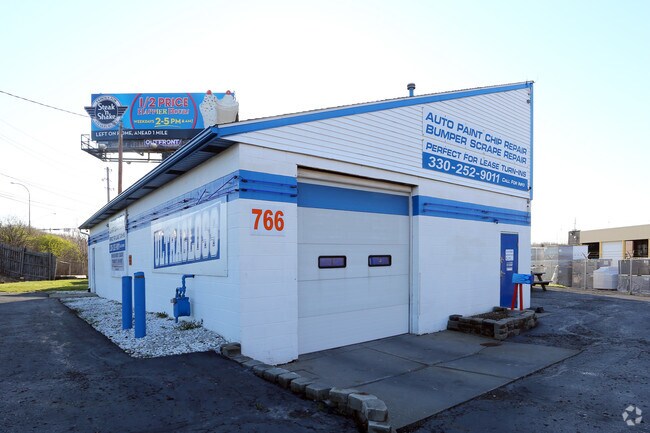
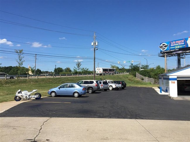
Property Record
766 E Glenwood Ave, Akron, OH 44310

Property Detail
766 E Glenwood Ave
Akron, OH
TR 9 LOT 1 S OF TALLAVE & BREEN MC CAUSLAND LOT 119 TRIA N LESS PRT FOR RD 46-WD
67-41388
Summit
Autorepair
Ohio
B and X Area of moderate flood hazard, usually the area between the limits of the 100-year and 500-year floods.
1,119
2023
0.31 AC
2025
Akron
502200
Cleveland
3,105 SF
NEARBY LISTINGS FOR SALE OR LEASE
DEMOGRAPHICS near 766 E Glenwood Ave
1 mile
3 mile
5 mile
2024 Total Population
10,277
99,963
237,411
2029 Population
10,234
100,116
237,798
Pop Growth 2024-2029
(0.42%)
+ 0.15%
+ 0.16%
Average Age
38
39
40
2024 Total Households
3,980
43,037
103,730
HH Growth 2024-2029
(0.45%)
+ 0.13%
+ 0.12%
Median Household Inc
$37,616
$50,706
$54,419
Avg Household Size
2.40
2.20
2.20
2024 Avg HH Vehicles
1.00
1.00
2.00
Median Home Value
$100,587
$144,386
$155,117
Median Year Built
1953
1952
1956
Nearby Places
Map Layers
Map Styles
 Street
 Aerial
Transit
 Traffic
 Biking
Places
Listings with unknown addresses are not visible on the map
- Restaurants
- Banks
- Shops
- Fitness
- Groceries
PUBLIC TRANSPORTATION
COMMUTER RAIL
Drive
Walk
Distance
6 min
2.3 mi
Drive
Walk
Distance
11 min
4.6 mi
AIRPORT
Akron-Canton Regional
Drive
Walk
Distance
Akron-Canton Regional
21 min
15.3 mi
Cleveland-Hopkins International
Drive
Walk
Distance
Cleveland-Hopkins International
55 min
39.9 mi
Nearby Properties
Address
Land Use
TOTAL SIZE
Lot Size
Zoning
Address
Land Use
TOTAL SIZE
Lot Size
Zoning
1,811,279 SF
38.71 AC
Address
Land Use
TOTAL SIZE
Lot Size
Zoning
1,004,220 SF
3.84 AC
Address
Land Use
TOTAL SIZE
Lot Size
Zoning
148,212 SF
2.84 AC
Address
Land Use
TOTAL SIZE
Lot Size
Zoning
348,519 SF
7.45 AC
Address
Land Use
TOTAL SIZE
Lot Size
Zoning
472,380 SF
4.55 AC
Address
Land Use
TOTAL SIZE
Lot Size
Zoning
225,751 SF
0.16 AC
Address
Land Use
TOTAL SIZE
Lot Size
Zoning
404,207 SF
2.19 AC
Address
Land Use
TOTAL SIZE
Lot Size
Zoning
92,152 SF
1.69 AC
Address
Land Use
TOTAL SIZE
Lot Size
Zoning
121,738 SF
1.60 AC
Address
Land Use
TOTAL SIZE
Lot Size
Zoning
314,622 SF
15.59 AC
Address
Land Use
TOTAL SIZE
Lot Size
Zoning
Address
Land Use
TOTAL SIZE
Lot Size
Zoning
3.15 AC
Address
Land Use
TOTAL SIZE
Lot Size
Zoning
257,958 SF
4.64 AC
Address
Land Use
TOTAL SIZE
Lot Size
Zoning
186,867 SF
1.48 AC
Address
Land Use
TOTAL SIZE
Lot Size
Zoning
229,392 SF
12.31 AC
Address
Land Use
TOTAL SIZE
Lot Size
Zoning
0.41 AC
Address
Land Use
TOTAL SIZE
Lot Size
Zoning
183,227 SF
4.29 AC
Address
Land Use
TOTAL SIZE
Lot Size
Zoning
347,139 SF
9.65 AC
Address
Land Use
TOTAL SIZE
Lot Size
Zoning
51,702 SF
0.36 AC
Address
Land Use
TOTAL SIZE
Lot Size
Zoning
3.16 AC
Address
Land Use
TOTAL SIZE
Lot Size
Zoning
66,302 SF
10.87 AC
Address
Land Use
TOTAL SIZE
Lot Size
Zoning
52,803 SF
1.33 AC
Address
Land Use
TOTAL SIZE
Lot Size
Zoning
311,197 SF
10.78 AC
Address
Land Use
TOTAL SIZE
Lot Size
Zoning
275,025 SF
0.98 AC
Address
Land Use
TOTAL SIZE
Lot Size
Zoning
118,928 SF
1.15 AC
Address
Land Use
TOTAL SIZE
Lot Size
Zoning
72,382 SF
4.70 AC
Address
Land Use
TOTAL SIZE
Lot Size
Zoning
232,791 SF
8.16 AC
Address
Land Use
TOTAL SIZE
Lot Size
Zoning
210,474 SF
1.87 AC
Address
Land Use
TOTAL SIZE
Lot Size
Zoning
215,975 SF
5.76 AC
Address
Land Use
TOTAL SIZE
Lot Size
Zoning
245,911 SF
14.48 AC
The World's #1 Commercial Real Estate Marketplace
Connect with us
© 2026 CoStar Group
The information above has been obtained from sources believed reliable. While we do not doubt its accuracy we have not verified it and make no guarantee, warranty or representation about it. It is your responsibility to independently confirm its accuracy and completeness. Any projections, opinions, assumptions, or estimates used are for example only and do not represent the current or future performance of the property. The value of this transaction to you depends on tax and other factors which should be evaluated by your tax, financial, and legal advisors. You and your advisors should conduct a careful, independent investigation of the property to determine to your satisfaction the suitability of the property for your needs.