Property Record
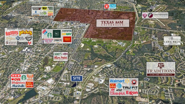
766 N Harvey Mitchell Pkwy, Bryan, TX 77807


Property Detail
766 N Harvey Mitchell Pkwy
College Station-Bryan, TX
ZENO PHILLIPS, BLOCK 17, LOT 49 (TR-203), ACRES 6.18
51136
BRAZOS
Commercialnec
Texas
A Areas with a 1% annual chance of flooding and a 26% chance of flooding over the life of a 30-year mortgage.
49
2024
6.18 AC
2025
Bryan & College Station
000205
Other Market Areas
1,800 SF
NEARBY LISTINGS FOR SALE OR LEASE
DEMOGRAPHICS near 766 N Harvey Mitchell Pkwy
1 mile
3 mile
5 mile
2025 Total Population
9,405
77,330
152,751
2030 Population
10,156
81,729
161,227
Pop Growth 2025-2030
+ 7.99%
+ 5.69%
+ 5.55%
Average Age
32
32
32
2025 Total Households
3,691
25,720
54,920
HH Growth 2025-2030
+ 8.18%
+ 6.63%
+ 6.19%
Median Household Inc
$48,858
$43,738
$42,701
Avg Household Size
2.50
2.40
2.30
2025 Avg HH Vehicles
2.00
2.00
2.00
Median Home Value
$199,999
$210,306
$230,188
Median Year Built
1992
1987
1990
Nearby Places
Map Layers
Map Styles
 Street
 Aerial
Transit
 Traffic
 Biking
Places
Listings with unknown addresses are not visible on the map
- Restaurants
- Banks
- Shops
- Fitness
- Groceries
PUBLIC TRANSPORTATION
AIRPORT
Easterwood Field
Drive
Walk
Distance
Easterwood Field
14 min
6.2 mi
Freight Ports
Port of Houston
Drive
Walk
Distance
Port of Houston
126 min
102.9 mi
SALE & LEASE HISTORY
LISTING DATE
SALE/LEASE

Oct 13, 2020
For Lease
Nearby Properties
Address
Land Use
TOTAL SIZE
Lot Size
Zoning
Address
Land Use
TOTAL SIZE
Lot Size
Zoning
527,548 SF
13.77 AC
Address
Land Use
TOTAL SIZE
Lot Size
Zoning
387,358 SF
1.82 AC
Address
Land Use
TOTAL SIZE
Lot Size
Zoning
308,612 SF
2.17 AC
Address
Land Use
TOTAL SIZE
Lot Size
Zoning
353,587 SF
154.61 AC
Address
Land Use
TOTAL SIZE
Lot Size
Zoning
381,196 SF
87 AC
Address
Land Use
TOTAL SIZE
Lot Size
Zoning
464,811 SF
2.15 AC
Address
Land Use
TOTAL SIZE
Lot Size
Zoning
302,580 SF
13.83 AC
Address
Land Use
TOTAL SIZE
Lot Size
Zoning
301,163 SF
3.22 AC
Address
Land Use
TOTAL SIZE
Lot Size
Zoning
232,070 SF
13.33 AC
Address
Land Use
TOTAL SIZE
Lot Size
Zoning
360,536 SF
4.05 AC
Address
Land Use
TOTAL SIZE
Lot Size
Zoning
396,301 SF
0.94 AC
Address
Land Use
TOTAL SIZE
Lot Size
Zoning
228,117 SF
37.23 AC
Address
Land Use
TOTAL SIZE
Lot Size
Zoning
17.89 AC
Address
Land Use
TOTAL SIZE
Lot Size
Zoning
503,906 SF
23.31 AC
Address
Land Use
TOTAL SIZE
Lot Size
Zoning
188,821 SF
86.82 AC
Address
Land Use
TOTAL SIZE
Lot Size
Zoning
389,708 SF
10.93 AC
Address
Land Use
TOTAL SIZE
Lot Size
Zoning
3,680 SF
48.92 AC
Address
Land Use
TOTAL SIZE
Lot Size
Zoning
212,117 SF
16.33 AC
Address
Land Use
TOTAL SIZE
Lot Size
Zoning
298,084 SF
5.04 AC
Address
Land Use
TOTAL SIZE
Lot Size
Zoning
382,110 SF
20.66 AC
Address
Land Use
TOTAL SIZE
Lot Size
Zoning
322,033 SF
3.04 AC
Address
Land Use
TOTAL SIZE
Lot Size
Zoning
128,532 SF
3.43 AC
Address
Land Use
TOTAL SIZE
Lot Size
Zoning
175,103 SF
9.88 AC
Address
Land Use
TOTAL SIZE
Lot Size
Zoning
109.89 AC
Address
Land Use
TOTAL SIZE
Lot Size
Zoning
59.92 AC
Address
Land Use
TOTAL SIZE
Lot Size
Zoning
263,162 SF
12.95 AC
Address
Land Use
TOTAL SIZE
Lot Size
Zoning
317,629 SF
9.14 AC
Address
Land Use
TOTAL SIZE
Lot Size
Zoning
403,036 SF
3.52 AC
Address
Land Use
TOTAL SIZE
Lot Size
Zoning
135,161 SF
1.42 AC
Address
Land Use
TOTAL SIZE
Lot Size
Zoning
261,919 SF
14.31 AC
The World's #1 Commercial Real Estate Marketplace
Connect with us
© 2026 CoStar Group
The information above has been obtained from sources believed reliable. While we do not doubt its accuracy we have not verified it and make no guarantee, warranty or representation about it. It is your responsibility to independently confirm its accuracy and completeness. Any projections, opinions, assumptions, or estimates used are for example only and do not represent the current or future performance of the property. The value of this transaction to you depends on tax and other factors which should be evaluated by your tax, financial, and legal advisors. You and your advisors should conduct a careful, independent investigation of the property to determine to your satisfaction the suitability of the property for your needs.