Property Record
7661 36Th Ave, Hudsonville, MI 49426


NEARBY LISTINGS FOR SALE OR LEASE
-
-
View all Hudsonville listings for sale on LoopNet.com
Property Detail
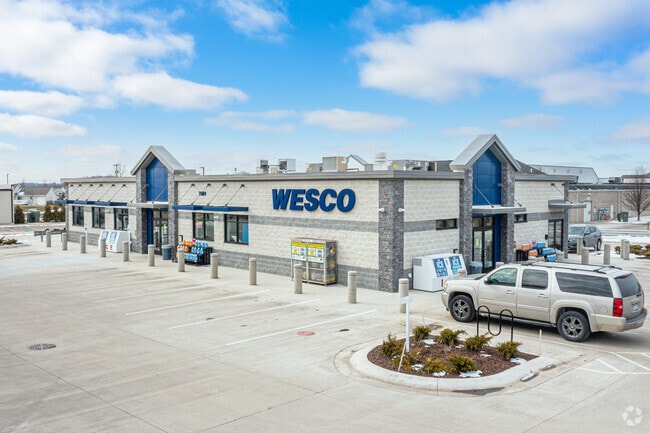
7661 36Th Ave
70-14-17-100-024
THAT PART OF NW 1/4 COM CEN 1/4 COR, TH N 0D 12M 01S E 263 FT & N 88D 59M 14S W 5001 FT TO W R/W LI OF 36TH AVE & PT OF BEG,
Conveniencestore
Ottawa
X
Michigan
26081C0400D
1.73 AC
2025
E Ottawa Cnty/Hudsonville
2025
West Michigan
024600
Grand Rapids-Wyoming-Kentwood, MI
5,100 SF
DEMOGRAPHICS near 7661 36Th Ave
1 Mile
3 Mile
5 Mile
2024 Total Population
6,638
43,159
88,163
2029 Population
6,987
45,297
92,258
Pop Growth 2024-2029
+ 5.26%
+ 4.95%
+ 4.64%
Average Age
35
37
36
2024 Total Households
2,078
14,240
29,786
HH Growth 2024-2029
+ 5.34%
+ 5.05%
+ 4.78%
Median Household Inc
$115,094
$100,082
$82,406
Avg Household Size
3.20
2.90
2.70
2024 Avg HH Vehicles
2.00
2.00
2.00
Median Home Value
$319,391
$270,611
$270,974
Median Year Built
1997
1986
1990
Nearby Places
Map Layers
Map Styles
 Street
 Aerial
- Restaurants
- Banks
- Shops
- Fitness
- Groceries
PUBLIC TRANSPORTATION
AIRPORT
Gerald R Ford International
DRIVE
WALK
Distance
Gerald R Ford International
38 min
20.8 mi
Nearby Properties
Address
Land Use
TOTAL SIZE
Lot Size
Zoning
Address
Land Use
TOTAL SIZE
Lot Size
Zoning
20.61 AC
HDR
Address
Land Use
TOTAL SIZE
Lot Size
Zoning
114,312 SF
22.23 AC
R-4
Address
Land Use
TOTAL SIZE
Lot Size
Zoning
22.06 AC
PUD
Address
Land Use
TOTAL SIZE
Lot Size
Zoning
116,088 SF
29.18 AC
N/A
Address
Land Use
TOTAL SIZE
Lot Size
Zoning
103,308 SF
18.76 AC
N/A
Address
Land Use
TOTAL SIZE
Lot Size
Zoning
124,950 SF
18.30 AC
MHR
Address
Land Use
TOTAL SIZE
Lot Size
Zoning
66,766 SF
R-1-A
Address
Land Use
TOTAL SIZE
Lot Size
Zoning
139,774 SF
10.67 AC
HDR-B
Address
Land Use
TOTAL SIZE
Lot Size
Zoning
47,386 SF
6.93 AC
LDR
Address
Land Use
TOTAL SIZE
Lot Size
Zoning
71,102 SF
8.65 AC
MHR
Address
Land Use
TOTAL SIZE
Lot Size
Zoning
142.51 AC
N/A
Address
Land Use
TOTAL SIZE
Lot Size
Zoning
8,448 SF
2.68 AC
R-4
Address
Land Use
TOTAL SIZE
Lot Size
Zoning
3,024 SF
74.75 AC
N/A
Address
Land Use
TOTAL SIZE
Lot Size
Zoning
66,980 SF
LDR
Address
Land Use
TOTAL SIZE
Lot Size
Zoning
44,400 SF
6.69 AC
HS
Address
Land Use
TOTAL SIZE
Lot Size
Zoning
32,576 SF
2.23 AC
PF
Address
Land Use
TOTAL SIZE
Lot Size
Zoning
768 SF
55.18 AC
N/A
Address
Land Use
TOTAL SIZE
Lot Size
Zoning
94,894 SF
7.35 AC
I
Address
Land Use
TOTAL SIZE
Lot Size
Zoning
24,678 SF
0.65 AC
CBD
Address
Land Use
TOTAL SIZE
Lot Size
Zoning
5,054 SF
3.86 AC
LDR
Address
Land Use
TOTAL SIZE
Lot Size
Zoning
39,306 SF
3.65 AC
I
Address
Land Use
TOTAL SIZE
Lot Size
Zoning
47,632 SF
4 AC
CS
Address
Land Use
TOTAL SIZE
Lot Size
Zoning
3.03 AC
PUD
Address
Land Use
TOTAL SIZE
Lot Size
Zoning
Address
Land Use
TOTAL SIZE
Lot Size
Zoning
52,856 SF
3.94 AC
I
Address
Land Use
TOTAL SIZE
Lot Size
Zoning
Address
Land Use
TOTAL SIZE
Lot Size
Zoning
12,324 SF
1.80 AC
NS
Address
Land Use
TOTAL SIZE
Lot Size
Zoning
35,916 SF
3.30 AC
CS
Address
Land Use
TOTAL SIZE
Lot Size
Zoning
10,267 SF
1.99 AC
NS
Address
Land Use
TOTAL SIZE
Lot Size
Zoning
30,000 SF
3.47 AC
HS
The World's #1 Commercial Real Estate Marketplace
Connect with us
© 2026 CoStar Group
The information above has been obtained from sources believed reliable. While we do not doubt its accuracy we have not verified it and make no guarantee, warranty or representation about it. It is your responsibility to independently confirm its accuracy and completeness. Any projections, opinions, assumptions, or estimates used are for example only and do not represent the current or future performance of the property. The value of this transaction to you depends on tax and other factors which should be evaluated by your tax, financial, and legal advisors. You and your advisors should conduct a careful, independent investigation of the property to determine to your satisfaction the suitability of the property for your needs.