Property Record
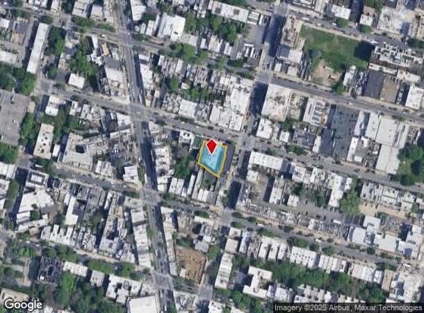
768 Bergen St, Brooklyn, NY 11238
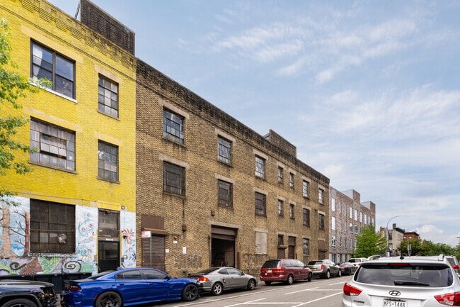
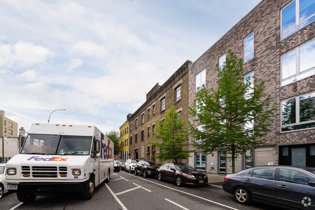

This Property Is For Sale
Current Lease Availabilities
NEARBY LISTINGS FOR SALE OR LEASE
Property Detail
768 Bergen St
01147-0021
DOCID-2014010201245001
Industrialgeneral
Kings
X
New York
3604970212F
21
2024
0.25 AC
2025
North Brooklyn
020500
Long Island (New York)
35,338 SF
New York-Jersey City-White Plains, NY-NJ
DEMOGRAPHICS near 768 Bergen St
1 Mile
3 Mile
5 Mile
2024 Total Population
184,081
1,316,255
2,787,280
2029 Population
175,494
1,246,240
2,607,859
Pop Growth 2024-2029
(4.66%)
(5.32%)
(6.44%)
Average Age
38
38
38
2024 Total Households
80,348
515,608
1,098,517
HH Growth 2024-2029
(5.19%)
(5.73%)
(6.68%)
Median Household Inc
$104,047
$75,802
$79,958
Avg Household Size
2.20
2.40
2.40
2024 Avg HH Vehicles
.00
.00
.00
Median Home Value
$1,047,522
$959,765
$876,839
Median Year Built
1947
1948
1948
Nearby Places
Map Layers
Map Styles
 Street
 Aerial
- Restaurants
- Banks
- Shops
- Fitness
- Groceries
PUBLIC TRANSPORTATION
TRANSIT/SUBWAY
Clinton-Washington Avenues (A,C Line) (A - New York MTA Subway (The Subway), C - New York MTA Subway (The Subway))
DRIVE
WALK
Distance
Clinton-Washington Avenues (A,C Line) (A - New York MTA Subway (The Subway), C - New York MTA Subway (The Subway))
2 min
8 min
0.4 mi
Park Place (S Line) (Franklin Avenue Shuttle - New York MTA Subway (The Subway))
DRIVE
WALK
Distance
Park Place (S Line) (Franklin Avenue Shuttle - New York MTA Subway (The Subway))
2 min
9 min
0.5 mi
Eastern Parkway-Brooklyn Museum (2 - New York MTA Subway (The Subway), 3 - New York MTA Subway (The Subway), 4 - New York MTA Subway (The Subway))
DRIVE
WALK
Distance
Eastern Parkway-Brooklyn Museum (2 - New York MTA Subway (The Subway), 3 - New York MTA Subway (The Subway), 4 - New York MTA Subway (The Subway))
3 min
11 min
0.6 mi
Franklin Avenue (A,C,S Line) (A - New York MTA Subway (The Subway), C - New York MTA Subway (The Subway), Franklin Avenue Shuttle - New York MTA Subway (The Subway))
DRIVE
WALK
Distance
Franklin Avenue (A,C,S Line) (A - New York MTA Subway (The Subway), C - New York MTA Subway (The Subway), Franklin Avenue Shuttle - New York MTA Subway (The Subway))
3 min
12 min
0.6 mi
Grand Army Plaza (2 - New York MTA Subway (The Subway), 3 - New York MTA Subway (The Subway), 4 - New York MTA Subway (The Subway))
DRIVE
WALK
Distance
Grand Army Plaza (2 - New York MTA Subway (The Subway), 3 - New York MTA Subway (The Subway), 4 - New York MTA Subway (The Subway))
3 min
12 min
0.7 mi
COMMUTER RAIL
Nostrand Avenue Station (Far Rockaway Branch - Long Island Rail Road, Hempstead Branch - Long Island Rail Road, Long Beach Branch - Long Island Rail Road, West Hempstead Branch - Long Island Rail Road)
DRIVE
WALK
Distance
Nostrand Avenue Station (Far Rockaway Branch - Long Island Rail Road, Hempstead Branch - Long Island Rail Road, Long Beach Branch - Long Island Rail Road, West Hempstead Branch - Long Island Rail Road)
3 min
17 min
0.9 mi
Flatbush Avenue Station (Far Rockaway Branch - Long Island Rail Road, Hempstead Branch - Long Island Rail Road, Long Beach Branch - Long Island Rail Road, West Hempstead Branch - Long Island Rail Road)
DRIVE
WALK
Distance
Flatbush Avenue Station (Far Rockaway Branch - Long Island Rail Road, Hempstead Branch - Long Island Rail Road, Long Beach Branch - Long Island Rail Road, West Hempstead Branch - Long Island Rail Road)
5 min
1.1 mi
AIRPORT
LaGuardia
DRIVE
WALK
Distance
LaGuardia
20 min
10.0 mi
John F Kennedy International
DRIVE
WALK
Distance
John F Kennedy International
29 min
12.0 mi
Newark Liberty International
DRIVE
WALK
Distance
Newark Liberty International
35 min
15.9 mi
Freight Ports
NY - Red Hook Container Terminal
DRIVE
WALK
Distance
NY - Red Hook Container Terminal
1 min
2.3 mi
Nearby Properties
Address
Land Use
TOTAL SIZE
Lot Size
Zoning
Address
Land Use
TOTAL SIZE
Lot Size
Zoning
2,812,739 SF
2.10 AC
C5-3
Address
Land Use
TOTAL SIZE
Lot Size
Zoning
7,058,736 SF
147.61 AC
M3-1
Address
Land Use
TOTAL SIZE
Lot Size
Zoning
869,038 SF
1.53 AC
M1-1
Address
Land Use
TOTAL SIZE
Lot Size
Zoning
92,440 SF
466.23 AC
R5
Address
Land Use
TOTAL SIZE
Lot Size
Zoning
2,542,066 SF
174.49 AC
R3-2
Address
Land Use
TOTAL SIZE
Lot Size
Zoning
1,503,150 SF
20.47 AC
R5
Address
Land Use
TOTAL SIZE
Lot Size
Zoning
393.54 AC
PARK
Address
Land Use
TOTAL SIZE
Lot Size
Zoning
2,948,300 SF
27.71 AC
R7-2
Address
Land Use
TOTAL SIZE
Lot Size
Zoning
577,381 SF
3.19 AC
R6
Address
Land Use
TOTAL SIZE
Lot Size
Zoning
890,142 SF
2.22 AC
R7-1
Address
Land Use
TOTAL SIZE
Lot Size
Zoning
1,079,361 SF
1.07 AC
C5-3
Address
Land Use
TOTAL SIZE
Lot Size
Zoning
902,000 SF
6.44 AC
M3-1
Address
Land Use
TOTAL SIZE
Lot Size
Zoning
943,802 SF
0.97 AC
C6-9
Address
Land Use
TOTAL SIZE
Lot Size
Zoning
1,258,851 SF
2.20 AC
C6-4
Address
Land Use
TOTAL SIZE
Lot Size
Zoning
830,879 SF
1 AC
C5-4
Address
Land Use
TOTAL SIZE
Lot Size
Zoning
835,231 SF
11.32 AC
R6
Address
Land Use
TOTAL SIZE
Lot Size
Zoning
990,250 SF
1.12 AC
C6-9
Address
Land Use
TOTAL SIZE
Lot Size
Zoning
1,061,228 SF
8.86 AC
R5
Address
Land Use
TOTAL SIZE
Lot Size
Zoning
579,404 SF
4.80 AC
R6
Address
Land Use
TOTAL SIZE
Lot Size
Zoning
512,755 SF
1.19 AC
R6
Address
Land Use
TOTAL SIZE
Lot Size
Zoning
879,916 SF
1.35 AC
C6-4
Address
Land Use
TOTAL SIZE
Lot Size
Zoning
627,018 SF
1.21 AC
C6-4
Address
Land Use
TOTAL SIZE
Lot Size
Zoning
550,232 SF
1.68 AC
R7-2
Address
Land Use
TOTAL SIZE
Lot Size
Zoning
561,945 SF
11.58 AC
R6
Address
Land Use
TOTAL SIZE
Lot Size
Zoning
905,298 SF
1.60 AC
C61A
Address
Land Use
TOTAL SIZE
Lot Size
Zoning
1,264,820 SF
17.93 AC
R7-2
Address
Land Use
TOTAL SIZE
Lot Size
Zoning
296,915 SF
0.31 AC
C5-3
Address
Land Use
TOTAL SIZE
Lot Size
Zoning
392,162 SF
1.86 AC
M3-1
Address
Land Use
TOTAL SIZE
Lot Size
Zoning
503,608 SF
1.64 AC
R8
Address
Land Use
TOTAL SIZE
Lot Size
Zoning
582,359 SF
0.99 AC
C6-4
The World's #1 Commercial Real Estate Marketplace
Connect with us
© 2025 CoStar Group
The information above has been obtained from sources believed reliable. While we do not doubt its accuracy we have not verified it and make no guarantee, warranty or representation about it. It is your responsibility to independently confirm its accuracy and completeness. Any projections, opinions, assumptions, or estimates used are for example only and do not represent the current or future performance of the property. The value of this transaction to you depends on tax and other factors which should be evaluated by your tax, financial, and legal advisors. You and your advisors should conduct a careful, independent investigation of the property to determine to your satisfaction the suitability of the property for your needs.